Meadow Valley Mountains
The Meadow Valley Mountains is a mountain range in Lincoln and Clark counties in southern Nevada.[1] The range is a narrow north to northeast trending ridgeline with a length of about 40 miles (64 km). The Clover Mountains lie to the north, Meadow Valley Wash and the Mormon Mountains to the east, the Moapa Valley to the southeast, Arrow Canyon Range to the south, Coyote Springs Valley to the southwest and the Kane Springs Valley and Delamar Mountains to the west and northwest.[2][3]
| Meadow Valley Mountains | |
|---|---|
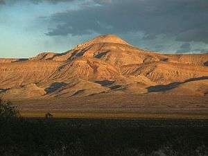 Sunflower Mountain in the Meadow Valley Mountains | |
| Highest point | |
| Peak | Unnamed peak |
| Elevation | 1,759 m (5,771 ft) |
| Coordinates | 37°01′53″N 114°47′35″W |
| Geography | |
| Country | United States |
| State | Nevada |
| District | Lincoln County |
| Range coordinates | 37°4′36.883″N 114°43′23.990″W |
| Topo map | USGS Sunflower Mountain |

Established in 2004 by the U.S. Congress and managed by the U.S. Bureau of Land Management, the bulk of the range lies within the Meadow Valley Range Wilderness. The wilderness area consists of three major landforms: the long ridgeline of the Meadow Valley Mountains, a large bajada beginning high on the main ridge sloping easterly towards Meadow Valley Wash, and finally the Bunker Hills five miles from the southern section of the central bajada. Conical Sunflower Mountain (elevation 5,022 feet (1,531 m)[4]) sits astride the main ridgeline.[5]
References
- "Meadow Valley Mountains". Geographic Names Information System. United States Geological Survey. Retrieved 2009-05-04.
- Clover Mts., Nevada–Utah, 30x60 Minute Topographic Quadrangle, USGS, 1978
- Overton, Nevada–Arizona, 30x60 Minute Topographic Quadrangle, USGS, 1987
- Sunflower Mtn., Nevada, 7.5 Minute Topographic Quadrangle, USGS, 1969
- Meadow Valley Range Wilderness Area - Wilderness Connect
External links
- Meadow Valley Range Wilderness - Friends of Nevada Wilderness
- Photos of Meadow Valley Range Wilderness by BLM