Maynard Lake
Maynard Lake is located on the English River system, 80 kilometres (50 mi) northeast of Kenora, Ontario.
| Maynard Lake | |
|---|---|
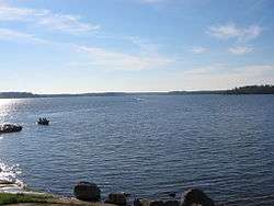 View from the Western shoreline around 7:45 AM | |
| Location | Ontario |
| Coordinates | 50.359°N 93.888°W |
| Primary inflows | English River |
| Primary outflows | Maynard Falls |
| Basin countries | Canada |
| Surface area | 12.3 square miles (32 km2) |
| Max. depth | 135 feet (41 m) |
| Surface elevation | 1,050 feet (320 m) Above Sea Level |
| Islands | 10 - 20 |
Access
Maynard Lake is only accessible via seaplane. During the winter it can be accessed by logging roads and ice roads.
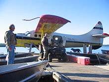
Walsten Air Otter tied to the dock at Maynard
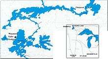
Map of the lake
gollark: Fair, although they're somewhat more *complex* than "magic uninterceptable channel"l.
gollark: So only stuff like PotatOS ship strong crypto nowadays.
gollark: The other way would be some sort of hypercomplex crypto solution, but it would probably have its own problems and I think SquidDev said no to including that sort of thing in core CraftOS.
gollark: If they made it magically uninterceptable, that would be uncool and bad for learning.
gollark: Anyway, if they removed the rednet API, that would break 12471892518295 programs but stop people using a not-secure-even-though-it-looks-like-it-is API.
See also
- List of lakes in Ontario
This article is issued from Wikipedia. The text is licensed under Creative Commons - Attribution - Sharealike. Additional terms may apply for the media files.