Mavri Sinia
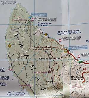
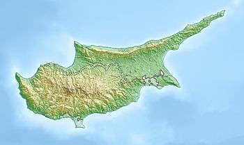
Mavri Sinia or Mavri Schinia is a mountain[1] in Neo Chorio in the Paphos District of Cyprus.[2] Is located at 429 m above sea level.[3][4] The terrain around Mavri Schinia is hilly on the east, but flat in the west and the sea is in the Northwest. Lára is the highest point nearby at an altitude of 669 m.[4][5] The average rainfall here is 631 mm annually.[6] January is the wettest month with an average of 141 mm precipitation. August is the driest with only 2 mm precipitation.[6] The nearest larger community is Pegeia 17.7 km south of Mavri Schinia. Neo Chorio is located at 4.4 km far from Mavri Schinia.[7]
Mavri Schinia | |
|---|---|
 | |
| Nickname(s): Mavri Sinia | |
 Mavri Schinia Mountain in Neo Chorio | |
| Coordinates: 35°02′10″N 32°19′38″E | |
| Country | |
| District | Paphos District |
| Elevation | 429 m (1,407 ft) |
| Time zone | UTC+2 (EET) |
| • Summer (DST) | UTC+3 (EEST) |
Climate
| Climate data for Mavri Sinia, Cyprus (429 m) | |||||||||||||
|---|---|---|---|---|---|---|---|---|---|---|---|---|---|
| Month | Jan | Feb | Mar | Apr | May | Jun | Jul | Aug | Sep | Oct | Nov | Dec | Year |
| Average high °F (°C) | 59 (15) |
59 (15) |
61 (16) |
66 (19) |
72 (22) |
79 (26) |
82 (28) |
84 (29) |
81 (27) |
75 (24) |
70 (21) |
63 (17) |
71 (22) |
| Average low °F (°C) | 45 (7) |
43 (6) |
45 (7) |
50 (10) |
55 (13) |
63 (17) |
66 (19) |
68 (20) |
64 (18) |
59 (15) |
54 (12) |
48 (9) |
55 (13) |
| Average precipitation inches (mm) | 5.6 (141) |
3.4 (86) |
2.0 (50) |
1.2 (31) |
1.7 (43) |
0.4 (9) |
0.1 (2) |
0.1 (2) |
0.1 (3) |
2.0 (51) |
3.5 (90) |
4.8 (123) |
24.9 (631) |
| Source: https://neo.sci.gsfc.nasa.gov/dataset_index.php | |||||||||||||
gollark: Well, you would lose a few features, but there are mods to partly reimplement them.
gollark: There's the whole mess with modloaders past that...
gollark: (I still miss RotaryCraft!)
gollark: Yes, most good mods are still for that. It's like 1.7.10 all over again.
gollark: Er, CC: Tweaked. The new unofficial fork.
References
- "GeoNames.org". www.geonames.org. Retrieved 2019-07-23.
- "Mavri Schinia (Mavrischinia) Map, Weather and Photos - Cyprus: mountain - Lat:35.0375 and Long:32.3292". www.getamap.net. Retrieved 2019-07-23.
- "Neo Chorio Paphou - Cyprus". Cyprus. Retrieved 2019-07-23.
- Ekdoseis Horama (Firm) (c. 2011), Paphos : hodikos, touristikos chartēs eparchias & polēs = Paphos : regional road, tourist map & city plan, Ekdoseis Orama, ISBN 9789604486717, OCLC 840062150, retrieved 2019-07-23
- "Forecast for Lára". yr.no. Retrieved 2019-07-23.
- "Rainfall (1 month - TRMM, 1998-2016) | NASA". Rainfall (1 month - TRMM, 1998-2016) | NASA. 2019-07-23. Retrieved 2019-07-23.
- "Mavri Shinia / Mavri Shinia, Paphos, Cyprus, Asia". travelingluck.com. Retrieved 2019-07-23.
This article is issued from Wikipedia. The text is licensed under Creative Commons - Attribution - Sharealike. Additional terms may apply for the media files.