Maryland Route 670
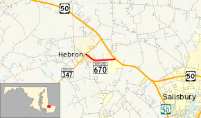
Maryland Route 670 (MD 670) is a state highway in the U.S. state of Maryland. Known as Lillian Street, the state highway runs 1.48 miles (2.38 km) from MD 347 east to U.S. Route 50 (US 50) within Hebron in western Wicomico County. MD 670 was constructed in the late 1930s.
| ||||
|---|---|---|---|---|
| Lillian Street | ||||
 | ||||
| Route information | ||||
| Maintained by MDSHA | ||||
| Length | 1.48 mi[1] (2.38 km) | |||
| Existed | 1939–present | |||
| Major junctions | ||||
| West end | ||||
| East end | ||||
| Location | ||||
| Counties | Wicomico | |||
| Highway system | ||||
| ||||
Route description
_at_Maryland_State_Route_347_(Main_Street)_in_Hebron%2C_Wicomico_County%2C_Maryland.jpg)
MD 670 begins at an intersection with MD 347 (Main Street) in the town of Hebron. The state highway heads southeast through the town, then turns east after passing Chestnut Tree Road and leaves the town limits. MD 670 continues east through farmland until its eastern terminus at US 50 (Ocean Gateway). Traffic heading eastbound on MD 670 is required to turn onto US 50 east; US 50 west can be accessed via a crossover in the divided highway a short distance to the east.[1][2]
History
MD 670 was under construction by 1936 and completed in 1939.[3][4] Direct access between eastbound MD 670 and westbound US 50 was removed in 2007.[5]
Junction list
The entire route is in Hebron, Wicomico County.
| mi[1] | km | Destinations | Notes | ||
|---|---|---|---|---|---|
| 0.00 | 0.00 | Western terminus | |||
| 1.48 | 2.38 | Eastern terminus; no direct access from eastbound MD 670 to westbound US 50 | |||
| 1.000 mi = 1.609 km; 1.000 km = 0.621 mi | |||||
See also

References
- Highway Information Services Division (December 31, 2013). Highway Location Reference. Maryland State Highway Administration. Retrieved 2010-10-21.
- Wicomico County (PDF).
- Google (2010-04-21). "Maryland Route 670" (Map). Google Maps. Google. Retrieved 2010-04-21.
- Maryland State Roads Commission (1936). Map of Maryland Showing State Road System (Map). Baltimore: Maryland State Roads Commission.
- Maryland State Roads Commission (1939). General Highway Map: State of Maryland (Map). Baltimore: Maryland State Roads Commission.
- Highway Information Services Division (December 31, 2007). Highway Location Reference. Maryland State Highway Administration. Retrieved 2010-10-21.
- Wicomico County (PDF).
