Maryland Route 489
Maryland Route 489 (MD 489) is a state highway in the U.S. state of Maryland. Known as Park Hall Road, the state highway runs 1.27 miles (2.04 km) from MD 5 east to MD 235 within Park Hall Estates in southern St. Mary's County. MD 489, which serves as a connector between MD 5 and MD 235 south of Lexington Park, was assigned to Park Hall Road in 1956.
| ||||
|---|---|---|---|---|
| Park Hall Road | ||||
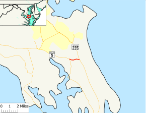 Maryland Route 489 highlighted in red | ||||
| Route information | ||||
| Maintained by MDSHA | ||||
| Length | 1.27 mi[1] (2.04 km) | |||
| Existed | 1956–present | |||
| Major junctions | ||||
| West end | ||||
| East end | ||||
| Location | ||||
| Counties | St. Mary's | |||
| Highway system | ||||
| ||||

Route description
_near_Three_Notch_Road_(Maryland_State_Route_235)_in_Lexington_Park%2C_St._Mary's_County%2C_Maryland.jpg)
MD 489 begins at an intersection with MD 5 (Point Lookout Road) in the unincorporated community of Park Hall Estates between St. Mary's City and Great Mills. The state highway heads east as a two-land road through a mix of farmland and forest. MD 489 reaches its eastern terminus at MD 235 (Three Notch Road) between Ridge and Lexington Park.[1][2]
History
MD 489 was assigned to Park Hall Road in 1956.[3] Aside from repaving, the state highway has changed very little since then.
Junction list
The entire route is in Park Hall Estates, St. Mary's County.
| mi[1] | km | Destinations | Notes | ||
|---|---|---|---|---|---|
| 0.00 | 0.00 | Western terminus | |||
| 1.27 | 2.04 | Eastern terminus | |||
| 1.000 mi = 1.609 km; 1.000 km = 0.621 mi | |||||
See also

References
- Highway Information Services Division (December 31, 2013). Highway Location Reference. Maryland State Highway Administration. Retrieved 2010-12-14.
- St. Mary's County (PDF).
- Google (2010-12-14). "Maryland Route 489" (Map). Google Maps. Google. Retrieved 2010-12-14.
- Maryland State Roads Commission (1956). Maryland: Official Highway Map (Map). Baltimore: Maryland State Roads Commission.