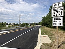
Maryland Route 373
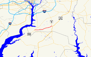
Maryland Route 373 (MD 373) is a state highway in the U.S. state of Maryland. Known as Accokeek Road, the highway runs 8.16 miles (13.13 km) from MD 210 in Accokeek east to Brandywine Road just east of MD 5 in Brandywine. Except for its westernmost segment that was built around 1930 as part of MD 224, MD 373 was designated and improved as a modern highway in the mid-1950s.
| ||||
|---|---|---|---|---|
 Maryland Route 373 highlighted in red | ||||
| Route information | ||||
| Maintained by MDSHA | ||||
| Length | 8.16 mi[1] (13.13 km) | |||
| Existed | 1955–present | |||
| Major junctions | ||||
| West end | ||||
| East end | Brandywine Road in Brandywine | |||
| Location | ||||
| Counties | Prince George's | |||
| Highway system | ||||
| ||||

Route description
MD 373 begins as Livingston Road at an intersection with MD 210 (Indian Head Highway) in Accokeek. Livingston Road continues west as unsigned MD 810J a short distance before becoming a county highway. MD 373 heads east as a two-lane undivided road, passing south of a park and ride lot serving MTA Maryland commuter buses, and continues straight on Accokeek Road when Livingston Road curves north. The highway turns north at its three-way intersection with Bealle Hill Road and turns east again at its second T junction with Bealle Hill Road. MD 373 continues east through the hamlet of Danville and curves around Lake Ruth, an impoundment of Burch Branch of Piscataway Creek. The highway intersects MD 5 (Branch Avenue) just west of its eastern terminus at a T intersection with county-maintained Brandywine Road in the hamlet of T.B. west of the center of Brandywine. This junction is just west of Brandywine Road's junction with unsigned MD 631 (Old Brandywine Road). Brandywine Road becomes a state highway, MD 381, at its intersection with U.S. Route 301 (Robert Crain Highway) to the east.[1][2]
History
The portion of MD 373 that follows Livingston Road was originally part of MD 224, which followed Livingston Road from Mason Springs in Charles County north to Washington.[3] That segment was constructed as a gravel road in 1929 and 1930.[4][5] The Accokeek–Brandywine county highway was improved as a gravel road from MD 224 to Danville Road by 1950; the section from there to MD 5 remained a graded dirt road.[6] In 1955, MD 373 was assigned to the highway from MD 5 west to Livingston Road—which was stripped of its MD 224 designation and transferred to county maintenance the same year—and then along Livingston Road to MD 210. The whole highway was also paved that year.[7] MD 373 originally had its eastern terminus at Brandywine Road's intersection with MD 631.[8] MD 373's terminus was relocated to its present T intersection with Brandywine Road in 2011 as part of the first phase of the project to construct an interchange between MD 5 and Brandywine Road and MD 373.[9]
Junction list
The entire route is in Prince George's County.
| Location | mi [1] | km | Destinations | Notes | |
|---|---|---|---|---|---|
| Accokeek | 0.00 | 0.00 | Western terminus; Livingston Road west of the intersection is MD 810J | ||
| Brandywine | 8.09 | 13.02 | |||
| 8.16 | 13.13 | Eastern terminus | |||
| 1.000 mi = 1.609 km; 1.000 km = 0.621 mi | |||||
See also

References
- Highway Information Services Division (December 31, 2013). Highway Location Reference. Maryland State Highway Administration. Retrieved 2012-11-14.
- Prince George's County (PDF).
- Google (2013-03-19). "Maryland Route 373" (Map). Google Maps. Google. Retrieved 2013-03-19.
- Maryland State Roads Commission (1939). General Highway Map: State of Maryland (Map). Baltimore: Maryland State Roads Commission.
- Uhl, G. Clinton; Bruce, Howard; Shaw, John K. (October 1, 1930). Report of the State Roads Commission of Maryland (1927–1930 ed.). Baltimore: Maryland State Roads Commission. p. 222. Retrieved 2013-03-19.
- Maryland Geological Survey (1930). Map of Maryland Showing State Road System: State Aid Roads and Improved County Road Connections (Map). Baltimore: Maryland Geological Survey.
- Maryland State Roads Commission (1950). Maryland: Official Highway Map (Map). Baltimore: Maryland State Roads Commission.
- Maryland State Roads Commission (1955). Maryland: Official Highway Map (Map). Baltimore: Maryland State Roads Commission.
- Highway Information Services Division (December 31, 2010). Highway Location Reference. Maryland State Highway Administration. Retrieved 2013-03-19.
- Prince George's County (PDF).
- "Project Information: MD 5 Branch Avenue at Brandywine Road (MD 373/MD 381)". Maryland State Highway Administration. Retrieved 2013-03-19.