Maryland Route 344
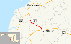
Maryland Route 344 (MD 344) is a state highway in the U.S. state of Maryland. Known as Chicamuxen Road, the state highway runs 2.16 miles (3.48 km) from MD 6 in Doncaster north to MD 224 near Chicamuxen. A connector between MD 6 and MD 224 in western Charles County, MD 344 was originally the southernmost part of MD 224. When MD 224 was rerouted to the west in the mid-1950s, MD 344 was assigned to its present course.
| ||||
|---|---|---|---|---|
| Chicamuxen Road | ||||
 | ||||
| Route information | ||||
| Maintained by MDSHA | ||||
| Length | 2.16 mi[1] (3.48 km) | |||
| Existed | 1957–present | |||
| Major junctions | ||||
| South end | ||||
| North end | ||||
| Location | ||||
| Counties | Charles | |||
| Highway system | ||||
| ||||

Route description
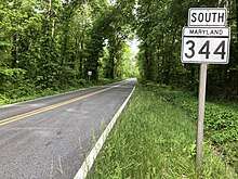
MD 344 begins at an intersection with MD 6 (Port Tobacco Road) in the hamlet of Doncaster. County-maintained Gilroy Road is the south leg of the four-way intersection. The state highway heads northwest as a two-lane undivided road through farmland and forest. MD 344 reaches its northern terminus at a T-intersection with MD 224 near Chicamuxen. Northbound MD 224 heads straight as Chicamuxen Road while southbound MD 224 heads west from the intersection as Riverside Road.[1][2]
History
The highway to which MD 344 is now assigned was originally the southern end of MD 224, which extended north to the District of Columbia boundary in Forest Heights.[3] The Doncaster–Chicamuxen portion of MD 224 was constructed in 1930.[4][5] When MD 224 was placed onto Riverside Road south to Riverside in 1957, MD 344 was assigned to the portion of Chicamuxen Road south of the MD 224–MD 344 intersection.[6]
Junction list
The entire route is in Charles County.
| Location | mi[1] | km | Destinations | Notes | |
|---|---|---|---|---|---|
| Doncaster | 0.00 | 0.00 | Southern terminus | ||
| Chicamuxen | 2.16 | 3.48 | Northern terminus | ||
| 1.000 mi = 1.609 km; 1.000 km = 0.621 mi | |||||
See also

References
- Highway Information Services Division (December 31, 2013). Highway Location Reference. Maryland State Highway Administration. Retrieved 2011-01-12.
- Charles County (PDF).
- Google (2010-03-22). "Maryland Route 344" (Map). Google Maps. Google. Retrieved 2010-03-22.
- Maryland State Roads Commission (1939). General Highway Map: State of Maryland (Map). Baltimore: Maryland State Roads Commission.
- Uhl, G. Clinton; Bruce, Howard; Shaw, John K. (October 1, 1930). Report of the State Roads Commission of Maryland (1927–1930 ed.). Baltimore: Maryland State Roads Commission. p. 207. Retrieved 2011-01-12.
- Maryland Geological Survey (1930). Map of Maryland Showing State Road System: State Aid Roads and Improved County Road Connections (Map). Baltimore: Maryland Geological Survey.
- Maryland State Roads Commission (1957). Maryland: Official Highway Map (Map). Baltimore: Maryland State Roads Commission.