Maryland Route 258
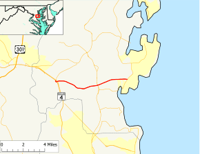
Maryland Route 258 (MD 258) is a state highway in the U.S. state of Maryland. Known as Bay Front Road, the route runs 7.13 miles (11.47 km) from Wrighton Road in Bristol east to Maryland Route 256 in Deale. MD 258 is the main connection between MD 4 and the southern Anne Arundel County bayside communities of Deale and Shady Side. MD 258 was constructed from MD 2 at Tracys Landing west to Bristol in the late 1920s and early 1930s. The highway was rebuilt at its western end and extended east from MD 2 to MD 256 in the early 1960s.
| ||||
|---|---|---|---|---|
| Bay Front Road | ||||
 Maryland Route 258 highlighted in red | ||||
| Route information | ||||
| Maintained by MDSHA | ||||
| Length | 7.13 mi[1] (11.47 km) | |||
| Existed | 1928–present | |||
| Major junctions | ||||
| West end | Wrighton Road in Bristol | |||
| East end | ||||
| Location | ||||
| Counties | Anne Arundel | |||
| Highway system | ||||
| ||||
Route description
_at_Maryland_State_Route_256_(Deale-Churchton_Road)_in_Deale%2C_Anne_Arundel_County%2C_Maryland.jpg)
MD 258 begins at an intersection with Wrighton Road, a county-maintained road, and an off-ramp from southbound MD 4 (Southern Maryland Boulevard) in Bristol. This intersection is just east of the northern end of Southern Maryland Boulevard, a frontage road that parallels southbound MD 4. A park and ride lot serving MTA Maryland commuter buses is located east of this intersection. MD 258 curves east, issues a ramp to southbound MD 4, and crosses the freeway. East of the freeway, the highway intersects an exit ramp from northbound MD 4 and the southern end of MD 794, another segment of Southern Maryland Boulevard that provides access to northbound MD 4 and MD 259 (Greenock Road). MD 258 continues east as a two-lane undivided road that crosses Cabin Branch and passes the historic home Portland Manor. The highway has intersections with a loop of the highway's old alignment, MD 796A, and crosses Lyons Creek before intersecting MD 2 (Solomons Island Road) just north of the hamlet of Tracys Landing. MD 258 continues east, bypassing the waterside community of Deale to the north. The highway crosses narrow Traceys Creek and wide Rockhold Creek before reaching its eastern terminus at a roundabout with MD 256 (Deale Churchton Road), which heads south into Deale and north toward Shady Side.[1][2]
History
MD 258 was constructed as a gravel road from MD 2 to west of Lyons Creek in 1928.[3] The highway was extended to a point east of Cabin Branch in 1929 and 1930.[4][5] The remainder of MD 258 west to Bristol was started in 1930 and completed by 1933.[4][6] The western terminus was originally at MD 416, which became MD 4 in 1965; the intersecting roadway at the terminus is now part of MD 794.[7][8] MD 258 was paved in 1949.[9] The highway was extended west to its present terminus at Wrighton Road when MD 416 was expanded to a four-lane divided highway and its interchange with MD 258 was built in 1961.[10][11] The portion of MD 258 between MD 2 and MD 256 was built on a new alignment in 1963.[12][13] The roundabout at MD 258's terminus at MD 256 was installed in 2007.[14]
Junction list
The entire route is in Anne Arundel County.
| Location | mi[1] | km | Destinations | Notes | |
|---|---|---|---|---|---|
| Bristol | 0.00 | 0.00 | Wrighton Road | Western terminus; north leg of intersection is exit ramp from southbound MD 4 | |
| 0.17 | 0.27 | Entrance ramp to southbound MD 4 only | |||
| 0.29 | 0.47 | ||||
| Tracys Landing | 4.26 | 6.86 | |||
| Deale | 7.13 | 11.47 | Roundabout; eastern terminus | ||
| 1.000 mi = 1.609 km; 1.000 km = 0.621 mi | |||||
See also

References
- Highway Information Services Division (December 31, 2013). Highway Location Reference. Maryland State Highway Administration. Retrieved 2012-11-24.
- Anne Arundel County (PDF).
- Google (2013-01-06). "Maryland Route 258" (Map). Google Maps. Google. Retrieved 2013-01-06.
- Maryland Geological Survey (1928). Map of Maryland: Showing State Road System and State Aid Roads (Map). Baltimore: Maryland Geological Survey.
- Uhl, G. Clinton; Bruce, Howard; Shaw, John K. (October 1, 1930). Report of the State Roads Commission of Maryland (1927–1930 ed.). Baltimore: Maryland State Roads Commission. pp. 196–197. Retrieved 2013-01-06.
- Maryland Geological Survey (1930). Map of Maryland Showing State Road System: State Aid Roads and Improved County Road Connections (Map). Baltimore: Maryland Geological Survey.
- Maryland Geological Survey (1933). Map of Maryland Showing State Road System: State Aid Roads and Improved County Road Connections (Map). Baltimore: Maryland Geological Survey.
- Maryland State Roads Commission (1939). General Highway Map: State of Maryland (Map). Baltimore: Maryland State Roads Commission.
- Maryland State Roads Commission (1965). Maryland: Official Highway Map (Map). Baltimore: Maryland State Roads Commission.
- Maryland State Roads Commission (1949). Maryland: Official Highway Map (Map). Baltimore: Maryland State Roads Commission.
- Federal Highway Administration (2012). "NBI Structure Number: 100000020078010". National Bridge Inventory. Federal Highway Administration.
- Maryland State Roads Commission (1962). Maryland: Official Highway Map (Map). Baltimore: Maryland State Roads Commission.
- Federal Highway Administration (2012). "NBI Structure Number: 100000020079010". National Bridge Inventory. Federal Highway Administration.
- Maryland State Roads Commission (1963). Maryland: Official Highway Map (Map). Baltimore: Maryland State Roads Commission.
- Highway Information Services Division (December 31, 2007). Highway Location Reference. Maryland State Highway Administration. Retrieved 2013-01-06.
- Anne Arundel County (PDF).
