Mary Ann Rocque
Mary Ann Rocque, born Mary Ann Scalé, (born about 1725, died after 1770) was a cartographer in 18th-century London. Her booklet titled A Set of Plans and Forts of America (1765) included two of the earliest published maps of the city of Albany, New York and also celebrated British victories over the French in North America.[1]
Mary Ann Rocque | |
|---|---|
| Other names | Mary Ann Scalé, M. A. Rocque, Mary Ann Bew, Ann Bew |
| Years active | 1840s-1860s |
| Spouse(s) | John Rocque |
Family
Mary Ann Scalé was born in England, the daughter of Bernard Scalé (who died in 1743) and niece of Peter Scalé. She was the older sister of Dublin-based surveyor and cartographer Peter Bernard Scalé.[2][3] Rocque married apothecary Edward Bew sometime before 1743.[4] In 1751 she married cartographer John Rocque, her brother's mentor,[5] who held the titles "Chorographer to the Prince of Wales" and "Topographer to His Royal Highness the Duke of Glouchester".[6] John Rocque died in 1762.[7]
The Scalé and Rocque families were Huguenots.[2] Another French cartographer in London, Louis Stanislaus de la Rochette, was married to her sister, Margaret.[8]
Career
In widowhood, Mary Ann Rocque took over her husband's Topographer title and carried on the family business in the Strand, going into partnership with Andrew Dury.[9][10][11] In 1762, Rocque published her late husband's A survey of the County of Surrey, the first large-scale survey of the English county of Surrey.[12][13]
Not simply content to maintain her late husband's business, Rocque published new and significant maps after his death.[14] In 1763, she published a new edition of her husband's The Environs of London Reduced from an Actual Survey in 16 Sheets, with a dedication "to the Right Honorable George Montague Earl of Cardigan, Baron Brudenell &c."[15]
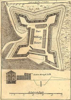
In 1765, she published A Set of Plans and Forts of America, a compilation atlas booklet consisting of thirty plans of forts and locales that had played important roles in the recently concluded French and Indian War; the atlas also included a small Plan of the City of Albany, which among other things showed the location of Fort Frederick along the city’s northwest edge.[1] Rocque's plan of Fort Federick and of the City of Albany are considered the two earliest published maps of the city of Albany, New York.[1] A Set of Plans and Forts of America were described by academic researcher Will C. van den Hoonaard as "a paean to British victory and a celebration of the enlarged empire".[16][7]
Around 1769, Rocque transferred most of her family cartography business to printer and publisher Carington Bowles (1723-1793).[17]
Maps published by Mary Ann Rocque are in many libraries and archives, including the National Archives, the Massachusetts Historical Society, the United States Military Academy, the University of Virginia, the British Library, and the UK Hydrographic Office.[18][19][14][20] Some of Rocque's maps were published under the name M. A. Rocque.[21]
References
- "One of the earliest Albany maps". Boston Rare Maps. Retrieved 24 March 2020.
- Mason, Adair Stuart (2004). 'Wasn't it Exciting!': A Compilation of the Work of A. Stuart Mason. Royal College of Physicians. p. 182. ISBN 978-1-86016-206-0.
- Bowen, B. P. (1947). "John Rocque's Maps of Dublin". Dublin Historical Record. 9 (4): 117–127. ISSN 0012-6861. JSTOR 30102615.
- J. H. Andrews, The French School of Dublin Land Surveyors, pp.284, 291n18
- "Scalé, Peter Bernard". Dictionary of Irish Architects. Retrieved 2020-03-22.
- "Rocque Biography". MapForum. Retrieved 2020-03-22.
- "Introduction to A Set of Plans and Forts in America, 1765". Massachusetts Historical Society. Retrieved 2020-03-22.
- Keppie, Lawrence (2015). "The French cartographer and the clan chief: Archaeological fieldwork in Perthshire, 1763" (PDF). Proc. Soc. Antiq. Scot. 145: 401.
- DeCosta, B. F. (April 1871). "Notes on the History of Fort George". The American Bibliopolist. 3: 113.
- Laura Bliss, The Hidden Histories of Maps Made By Women: Early North America, CityLab, March 21, 1016
- Andrew Macnair; Anne Rowe; Tom Williamson (2015). Dury and Andrews Map of Hertfordshire: Society and landscape in the eighteenth century. Windgather Press. p. 50. ISBN 978-1-909686-74-8.
- "ZMAP 5/18 '... this Actual survey of the County of Surrey... by ... Mary-Ann Rocque'. Guildord: Surrey Archelogical Society, 1931". The National Archives UK Discovery Catalogue. Retrieved 24 March 2020.
- "Surrey - The first large-scale survey of Surrey". Daniel Crouch Rare Books. Retrieved 24 March 2020.
- Harper, Tom. "Maps and women". British Library Maps and Views blog. Retrieved 24 March 2020.
- "Rare four sheet reduction of Rocque's map of Greater London". Daniel Crouch Rare Books. Retrieved 2020-03-22.
- Will C. van den Hoonaard (2013). Map Worlds: A History of Women in Cartography. Wilfrid Laurier Univ. Press. p. 61. ISBN 978-1-55458-934-0.
- "Rare four sheet reduction of Rocque's map of Greater London". Daniel Crouch Rare Books. Retrieved 24 March 2020.
- Library, United States Military Academy; Capps, Marie T.; Stroup, Theodore G. (1971). U.S. Military Academy Library Map Collection: The Period of the American Revolution, 1753-1800. West Point. p. 32.
- John Rocque, A set of plans and forts in America. London: Mary Ann Rocque, 1765; Tracy W. McGregor Library, University of Virginia.
- "United Kingdom Hydrographic Office Archive: SVY A/ D960 Aa1 Book A: Survey". The National Archives (UK) Discovery catalogue. Retrieved 24 March 2020.
- "A general map of North America". Norman B. Leventhal Map & Education Center. Retrieved 2020-03-22.
External links
- A Set of Plans and Forts in America at the Massachusetts Historical Society
- WO 78/5745 `A Topographical Map of the County of Surrey... by John Rocque' Published by Mary Ann Rocque. Three sheets (1768), at the National Archives.