Martin Luther King Bridge (Port Arthur, Texas)
The Martin Luther King Bridge or Gulfgate Bridge of Port Arthur, Texas is a cantilever bridge spanning the Sabine-Neches ship canal. It was opened in the 1970 to connect Port Arthur with Pleasure Island and Louisiana.[1]
Gulfgate Bridge | |
|---|---|
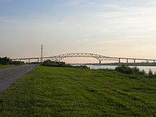 | |
| Coordinates | 29.8534°N 93.9484°W |
| Carries | two lanes of |
| Crosses | Gulf Intracoastal Waterway |
| Locale | Port Arthur, Texas |
| Official name | Martin Luther King Bridge |
| Maintained by | Texas Department of Transportation |
| ID number | TXNBI 201240236701001 |
| Characteristics | |
| Design | cantilever bridge |
| Total length | 5,032.4 feet (1,533.9 m) |
| Width | 27.9 feet (8.5 m) |
| Longest span | 664.1 feet (202.4 m) |
| Clearance above | 17.9 feet (5.5 m) |
| History | |
| Opened | 1970 |
%26groups%3D_e6b104d8235c960e0f906eba8db71b63f72ea457.svg)
| |
References
- "Bridgehunter.com - Martin Luther King Bridge". August 7, 2009. Retrieved June 13, 2011.
This article is issued from Wikipedia. The text is licensed under Creative Commons - Attribution - Sharealike. Additional terms may apply for the media files.