Maridalen
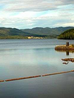
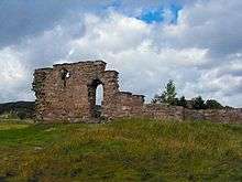
Maridalen is a valley situated just north of Oslo, Norway, just above the suburb of Kjelsås. Considering that Maridalen is within the City of Oslo, Maridalen has a very low population density. The valley is consisting of forests, lakes and agricultural areas. Most of the valley is made up of a lake known as Maridalsvannet, that serves as the primary source of drinking water for 90% of Oslo's population.[1] The only hydroelectric powerplant within the City of Oslo, Hammeren Hydroelectric Power Station is located at Brekke in Maridalen. The valley is a popular recreational area with many hiking trails and cycle tracks for summer usage, and groomed cross-country trails in winter. Both the lake and valley are protected.[2] Maridalen Church and the church ruins of the ancient St. Margaret's Church are located north of lake Maridalsvannet. There is a local bus upwards Maridalen from Nydalen Subway Station.[3]


Railway
The Gjøvikbanen railway passes through Maridalen. Originally, the trains stopped at three stations in the area. Movatn Station (created in 1900) is an unattended stop at Movatn. The Snippen stop (taken into use in 1934) was an unmanaged train stop with the address Greveveien. Sandermosen Station is a previously operated stop between Kjelsås Station and Snippen train stop. It was put into use in 1909, but closed in 2006.
The name
The Norse form of the name was Margrétardalr. The first element is the genitive of Margrét, the last element is dalr m 'dale, valley'. The old church (now in ruins) just north of the lake was dedicated to Margaret the Virgin.
The name of the valley cannot be older than the Christian movement of Norway (around 1000 AD), and it probably replaced an older name that has since been forgotten. This is one of rare examples in Norway where an old name of a large valley has been replaced.
References
- Municipality of Oslo (17 September 2008). "Ofte stilte spørsmål om nye Oset vannbehandlingsanlegg" (in Norwegian). Archived from the original on 11 June 2008. Retrieved 23 March 2009.
- Norwegian Directorate for Nature Management. "Verneområder i Oslo sortert på kommuner" (in Norwegian). Archived from the original on 11 June 2008. Retrieved 23 March 2009.
- Time table (Local bus, Maridalen) Ruter