Mapperley, Derbyshire
Mapperley is a village and civil parish in the Amber Valley district of Derbyshire, England, situated 7 miles (11 km) northeast of Derby and 2 miles (3 km) northwest of Ilkeston.[1] In the 2001 census it had a population of 253,[2] increasing to 289 at the 2011 Census.[3]
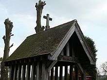
The Lychgate of the church
The village is on a loop off the A609 Nottingham to Belper road. A minor road leading to Shipley was closed by Derbyshire County Council in 2007.[4]
The village is inaccessible from the rest of Amber Valley by road.
The facilities in the village include a church, a C of E primary school and a pub.[5]
Mapperley Colliery, which was in operation from 1871 until 1965, was formerly a major employer in the area.[6]
References
- "GENUKI: Mapperley, Derbyshire". GENUKI. 27 October 2008. Retrieved 17 November 2009.
- "Full dataset view: Parish Headcounts: Amber Valley (Non-Metropolitan District)". Neighbourhood Statistics. Office for National Statistics. Retrieved 17 November 2009.
- "Civil Parish population 2011". Neighbourhood Statistics. Office for National Statistics. Retrieved 17 March 2016.
- "Villagers concerned over response times of emergency crews". thisisderbyshire. Derby Telegraph Media Group. 8 September 2009. Retrieved 17 November 2009.
- "Mapperley". Derbyshire UK - Guide to Derbyshire and the Peak District. Derbyshire UK. 2007. Retrieved 17 November 2009.
- "Common & Countryside" (PDF). Stanley and Stanley Common Parish Council. Retrieved 17 November 2009.
This article is issued from Wikipedia. The text is licensed under Creative Commons - Attribution - Sharealike. Additional terms may apply for the media files.