Map My Ancestors
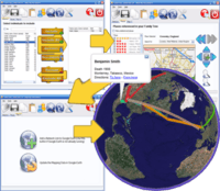
Map My Ancestors is an application for converting GEDCOM files produced by genealogy software into Keyhole Markup Language (KML) files for viewing with KML-compatible programs such as Google Earth or Google Maps. It can also convert comma-separated values (CSV) files produced by spreadsheet or database software into KML files.
 Mapping a family tree | |
| Developer(s) | Integrated Earth |
|---|---|
| Stable release | 1.8.7[1]
|
| Operating system | Windows |
| Type | Genealogy software |
| License | Proprietary |
| Website | www.familytreeassistant.com |
The application identifies places in the source data and Geocodes them to produce a list of latitudes and longitudes. The user has the opportunity to confirm map locations before viewing the data with Google Earth.
Features
- Supports GEDCOM 5.5.1 draft's Latitude and Longitude extensions.
- GEDCOM custom tags created by Legacy Family Tree and RootsMagic are supported for latitude and longitude data.
gollark: You can literally get free land anywhere unclaimed.
gollark: Use JEI to check the üses.
gollark: You can /sethome but not /setwarp.
gollark: @Tronzoid no.
gollark: Oops.
See also
- Family Tree Mapping
- Google Earth Virtual Globe software
- Bing Maps Platform
References
- Release History - Map My Ancestors
External links
This article is issued from Wikipedia. The text is licensed under Creative Commons - Attribution - Sharealike. Additional terms may apply for the media files.