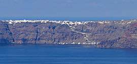
Manolas, Thirasia
Manolas (Greek: Μανωλάς) is the main settlement and the capital of Therasia,[2][3] the small island opposite to Santorini (Thera). It is located in the east of island, above the abrupt Santorini caldera. So it has a beautiful view for volcano and the main settlements of Santorini such as Fira, Imerovigli, Oia etc. The approach of Manolas becomes whether through the car road from the port of Riva or the uphill path from the small port of Korfos. The donkeys are the main transport mean in this path. Manolas has a population of 160 inhabitants according to 2011 census. It belongs to Thira municipality and Oia municipal unit.
Manolas | |
|---|---|
 General view of Manolas | |
 Manolas | |
| Coordinates: 36°28′N 24°21′E | |
| Country | Greece |
| Administrative region | South Aegean |
| Regional unit | Thira |
| Municipality | Thira |
| Population (2011)[1] | |
| • Municipal unit | 160 |
| Time zone | UTC+2 (EET) |
| • Summer (DST) | UTC+3 (EEST) |
| Vehicle registration | EM |
Historical population
| Census | Settlement |
|---|---|
| 1991 | 142 |
| 2001 | 147 |
| 2011 | 160 |
Places of interest
Manolas is a traditional cycladic village with the small, cubic houses, the white walls and the narrow roads. The settlement is located at the top of the island and it has a splendid view of the caldera. A notable building is the church of Saint Constantine, built in 1874.[3] A beautiful route around the village is the stone uphill path that joins Manolas with the small port Corfu. Near the village is the uninhabited settlement Kera and the traditional cycladic monastery of Panagia Trypiti or Kera, that is located 3 km south of Manolas.[4]
References
- "Απογραφή Πληθυσμού - Κατοικιών 2011. ΜΟΝΙΜΟΣ Πληθυσμός" (in Greek). Hellenic Statistical Authority.
- "Thirasia". egeonet.gr. Archived from the original on 29 November 2014. Retrieved 16 November 2014.
- "Thirasia Sightseeing". travelcyclades.gr. Retrieved 16 November 2014.
- "Thirasia sights". Retrieved 16 November 2014.
External links
- Περιήγηση santorini.gr (in Greek)