Mandagucha
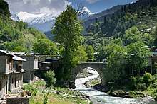
Mandagucha is a village located in Siran Valley, Mansehra District, Khyber Pakhtunkhwa, Pakistan. The village is on the route to one of the highest hilltops of the Himalaya series in Pakistan, Musa ka Musala (13,400 feet above sea level). Mandaguchha is the last station that is reachable by car or public transport. Though few tourist facilities exist in the village, residents are tourist-friendly. Mandagucha's cool temperatures and mountain views are attractive to tourists seeking to escape hot temperatures in June and July. Mandagucha is a tribal community of agriculturalists.[1][2][3][4]
Demographics
It has a population of around 20000 individuals. The major clans and casts are Gujjars, Syeds, Sawatis, Awans and Qureshis (Kotwals),Toda. Gujars are in majority but they mostly live as tenants and do not hold land. Qureshi's and Syeds are the other two castes. Most of the lands belong to Sawatis. Gujjar are a numerical minority.
History
The two influential Sawati families were Peer Khan family and Sultan Khan family. The village saw one of the most fierce conflicts between Gujjars and Sawatis in the late 1980s. This conflict was an outcome of years long suppression of Gujjar clans by the land owner Sawatis. A Left-inclined Kisan Mahaz (Farmer Front) motivated the Gujjers to stand against oppressive landlords. The conflict resulted in many liberties for the tenant classes, like freedom from free labor etc.
References
- So close to Musa ka Musalla (2017-01-08). "So close to Musa ka Musalla | TNS - The News on Sunday". Tns.thenews.com.pk. Retrieved 2017-01-15.
- http://www.nrb.gov.pk/lg_election/union.asp?district=73&dn=Mansehra Archived 2011-07-18 at the Wayback Machine
- "Manda Gucha". Mapcarta. Retrieved 2017-05-10.
- MandaGucha Map