Malay Falls, Nova Scotia
Malay Falls is a small rural community on the Eastern Shore of Nova Scotia, Canada, in the Halifax Regional Municipality.[3] The community is located along Route 374 and is about 11 km (6.8 mi) northeast of Sheet Harbour. The community is located along East River, and is adjacent to the Malay Falls Flowage, a lake along the river's course.[4][5][6] Malay Falls was first settled in 1784.[2] Colin Malay acquired land here in 1849, when the area was called Salmon River.[2] The Government of Canada maintains a weather station in the community.[7]
Malay Falls | |
|---|---|
Rural Community | |
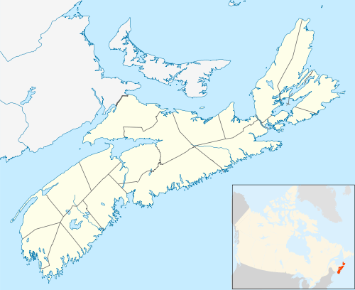 Malay Falls Location in Nova Scotia  Malay Falls Malay Falls (Canada) | |
| Coordinates: 44°58′29.8″N 62°28′59.4″W | |
| Country | Canada |
| Province | Nova Scotia |
| Municipality | Halifax Regional Municipality |
| District | 2[1] |
| Founded | 1784[2] |
| Government | |
| • Type | Municipal |
| • Mayor | Mike Savage |
| • Councillor | David Hendsbee |
| Time zone | UTC-4 (Atlantic Standard Time) |
| • Summer (DST) | UTC-3 (Atlantic Daylight Saving Time) |
| Canadian postal code | B0J 3B0 |
| GNBC Code | CAXHX[3] |
| NTS Map | 011D16 |
| Weather Station Code | CXMY |
| Rural Route | RR 2 |
| Highway | |
Climate
| Climate data for Malay Falls, 1981–2010 normals, extremes 1987–present | |||||||||||||
|---|---|---|---|---|---|---|---|---|---|---|---|---|---|
| Month | Jan | Feb | Mar | Apr | May | Jun | Jul | Aug | Sep | Oct | Nov | Dec | Year |
| Record high °C (°F) | 15.0 (59.0) |
18.0 (64.4) |
28.0 (82.4) |
26.3 (79.3) |
33.0 (91.4) |
34.9 (94.8) |
34.6 (94.3) |
35.8 (96.4) |
34.4 (93.9) |
27.0 (80.6) |
21.2 (70.2) |
15.7 (60.3) |
35.8 (96.4) |
| Average high °C (°F) | −0.6 (30.9) |
−0.4 (31.3) |
3.0 (37.4) |
8.0 (46.4) |
14.0 (57.2) |
19.9 (67.8) |
23.3 (73.9) |
23.2 (73.8) |
19.2 (66.6) |
13.3 (55.9) |
7.3 (45.1) |
1.9 (35.4) |
11.0 (51.8) |
| Daily mean °C (°F) | −5.8 (21.6) |
−5.6 (21.9) |
−2.0 (28.4) |
3.2 (37.8) |
8.4 (47.1) |
13.7 (56.7) |
17.5 (63.5) |
17.6 (63.7) |
13.7 (56.7) |
8.2 (46.8) |
3.2 (37.8) |
−2.6 (27.3) |
5.8 (42.4) |
| Average low °C (°F) | −10.9 (12.4) |
−10.9 (12.4) |
−6.9 (19.6) |
−1.7 (28.9) |
2.8 (37.0) |
7.5 (45.5) |
11.5 (52.7) |
11.8 (53.2) |
8.2 (46.8) |
3.1 (37.6) |
−1.0 (30.2) |
−7.0 (19.4) |
0.5 (32.9) |
| Record low °C (°F) | −28.5 (−19.3) |
−30.0 (−22.0) |
−24.3 (−11.7) |
−12.0 (10.4) |
−8.0 (17.6) |
−3.0 (26.6) |
1.0 (33.8) |
0.0 (32.0) |
−3.5 (25.7) |
−9.0 (15.8) |
−22.0 (−7.6) |
−31.0 (−23.8) |
−31.0 (−23.8) |
| Average precipitation mm (inches) | 146.0 (5.75) |
130.1 (5.12) |
151.8 (5.98) |
132.2 (5.20) |
134.8 (5.31) |
108.2 (4.26) |
107.4 (4.23) |
91.1 (3.59) |
147.5 (5.81) |
165.8 (6.53) |
177.0 (6.97) |
151.2 (5.95) |
1,643 (64.69) |
| Average snowfall cm (inches) | 28.0 (11.0) |
32.2 (12.7) |
23.2 (9.1) |
8.8 (3.5) |
0.4 (0.2) |
0 (0) |
0 (0) |
0 (0) |
0 (0) |
0 (0) |
4.6 (1.8) |
27.4 (10.8) |
124.5 (49.0) |
| Average precipitation days (≥ 0.2 mm) | 10.7 | 9.4 | 11.1 | 11.3 | 11.5 | 10.3 | 9.1 | 9.4 | 9.6 | 11.4 | 13.2 | 11.2 | 128.2 |
| Average snowy days (≥ 0.2 cm) | 4.6 | 4.9 | 3.5 | 1.4 | 0.08 | 0 | 0 | 0 | 0 | 0 | 1.1 | 4.1 | 19.7 |
| Source: Environment Canada[8][9] | |||||||||||||
Places adjacent to Malay Falls, Nova Scotia | ||||||||||
|---|---|---|---|---|---|---|---|---|---|---|
| ||||||||||
gollark: Oh. Hmm.
gollark: ~~it's probably allocating a few KB a second at most, which is only few MB an hour, so you can just ignore it to be a true full stack developer~~
gollark: XTREME PROGRAMMING fix: use a JS exploit to restart the user's browser every 20 minutes it runs.
gollark: Memory leak? Memory leak.
gollark: Too late, I've recorded it and stolen it for potatOS.
References
Citations
- "Current Polling District Boundaries". Halifax Regional Municipality. Retrieved 31 December 2018.
- Scott 2011, p. 153.
- "Malay Falls". Natural Resources Canada. Retrieved 31 December 2018.
- "Google Maps". Google. Retrieved 1 December 2016.
- "Malay Falls Flowage". Natural Resources Canada. Retrieved 6 November 2016.
- "East River Sheet Harbour". Natural Resources Canada. Retrieved 1 December 2016.
- "Malay Falls, NS". Government of Canada. Retrieved 1 December 2016.
- "Malay Falls, NS". Environment Canada. Retrieved 2 March 2017.
- "Malay Falls". Environment Canada. Retrieved 2 March 2017.
Bibliography
Scott, David (2011). Nova Scotia Place Names. DESPUB. ISBN 978-0-9865370-1-1.
This article is issued from Wikipedia. The text is licensed under Creative Commons - Attribution - Sharealike. Additional terms may apply for the media files.