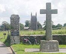
Maker, Cornwall
Maker (Cornish: Magor) is a village between Cawsand and Rame Head, Rame Peninsula, Cornwall, United Kingdom.

The name means a ruin or old wall in Cornish, possibly because the church was built from the ruins of West Stonehouse in Cremyll.[1] This origin of the name is unlikely, as Maker is first referred to in 705AD,[2] which predates the construction of the church. Another supposition, is that the "old walls" are those of a (now lost) Roman-British villa.[3] However, another Celtic name is Egloshayle, (not to be confused with Egloshayle on the River Camel) which means, the church on the estuary'.' [4]
The village and its neighbour Rame are in the civil parish of Maker with Rame and the parliamentary constituency of South East Cornwall. The parish had a population of 1,020 at the 2011 census.[5]
History
In their western advance across South West England, the West Saxons halted at the Tamar, but in 705, King Geraint of Dumnonia gave the promontory on the Cornish side of the mouth of the River Tamar to Sherborne Abbey,[6] to keep control of the Tamar mouth in West Saxon hands. This was royal land, and remained in Devon until the Counties (Detached Parts) Act 1844 regularised county exclaves across England. The Normans installed the Valletorts as tenants of most of the land controlling the Tamar. From them, Maker passed by marriage to the Durnford family and then to the Edgcumbes.
Maker was recorded in the Domesday Book (1086) when it was held by Reginald from Robert, Count of Mortain. There was 1 hide of land and land for 8 ploughs. There were 3 ploughs, 4 serfs, 6 villeins, 8 smallholders, 60 acres (24 ha) of pasture. The value of the manor was £1 sterling though it had formerly been worth £1 10s.[7]
Parish church
The Church of St Mary and St Julian is a typical 15th century Cornish church. It was a time of rebuilding throughout the country and churches were designed for preaching the word rather than stressing the liturgy. The aisles are the same length as the nave, and there is a massive western tower. The font is Norman, but was originally at St Merryn.[8] The Edgcumbe chapel was added in 1874.[9]
Fort Picklecombe
Fort Picklecombe, near Maker, was commissioned by Lord Palmerston as one of a series of coastal defences against possible French invasion.[10] It has since been converted into residential apartments.[11]
Notable residents
- William Hughes, barrister and writer, was born in Maker
References
- Hooe Lake Point and Earls Drive,www.southwestcoastpath.org.uk
- Geronitus Rex dedit Macuir de v hidis iuxta Thamar, Edwards, H (1988) The Charters of the Early West Saxon Kingdom, Oxford British Archaeological Reports, Page 245
- Letter in the Western Morning News, Dr W G Hoskins, (12th April, 1962)
- Egloshayle, Cornwall Information and Accommodation Guide, www.intocornwall.com
- "Civil Parish population 2011". Retrieved 10 February 2015.
- Geronitus Rex dedit Macuir de v hidis iuxta Thamar, Edwards, H (1988) The Charters of the Early West Saxon Kingdom, Oxford British Archaeological Reports, Page 245
- Thorn, C. et al., ed. (1979) Cornwall. Chichester: Phillimore; entry 5,2,14
- Cornish Church Guide (1925) Truro: Blackford; p. 152
- Church of St Mary and St Julian, historicengland.co.uk, GVI
- Picklecombe Fort,www.castlesfortsbattles,co.uk
- "Top 15 unusual buildings for sale". Daily Telegraph.
External links
![]()