Maine State Route 93
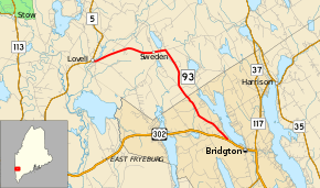
State Route 93 (SR 93) is part of Maine's system of numbered state highways, located in Oxford County. It is a minor highway in the western part of the state, running 11 miles (18 km) from U.S. Route 302 (US 302) in Bridgton to SR 5 in Lovell. It is signed as a north-south highway, but runs roughly southeast-to-northwest.
| ||||
|---|---|---|---|---|
 | ||||
| Route information | ||||
| Maintained by MaineDOT | ||||
| Length | 10.94 mi[1] (17.61 km) | |||
| Existed | 1953–present | |||
| Major junctions | ||||
| South end | ||||
| North end | ||||
| Location | ||||
| Counties | Oxford | |||
| Highway system | ||||
| ||||

Route description
SR 93 begins in the south at US 302 about two miles (3.2 km) west of downtown Bridgton. The road leaves town to the northwest, paralleling Highland Lake and Stearns Pond as it enters the town of Sweden. SR 93 continues northwest until reaching Waterford Road, where it turns due west towards the town of Lovell. Shortly after crossing the town line, SR 93 reaches its northern terminus at SR 5.[2]
History
Major intersections
The entire route is in Oxford County.
| Location | mi[1] | km | Destinations | Notes | |
|---|---|---|---|---|---|
| Bridgton | 0.00 | 0.00 | |||
| Lovell | 10.94 | 17.61 | |||
| 1.000 mi = 1.609 km; 1.000 km = 0.621 mi | |||||
See also

References
- "Maine DOT Map Viewer". Maine Office of GIS. Retrieved September 16, 2017.
- Google (September 16, 2017). "Maine State Route 93" (Map). Google Maps. Google. Retrieved September 16, 2017.