Maine State Route 188
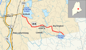
State Route 188 (SR 188) is part of Maine's system of numbered state highways, located in Penobscot County. It runs through three towns for the entire length: Enfield, Lowell, and Burlington. The route's western terminus is at SR 155 in Enfield. The route's eastern terminus is in southern Burlington near Saponac Pond where the road continues into the unorganized territory of East Central Penobscot as Grand Falls Road.[2]
| ||||
|---|---|---|---|---|
 | ||||
| Route information | ||||
| Maintained by MaineDOT | ||||
| Length | 12.99 mi[1] (20.91 km) | |||
| Major junctions | ||||
| West end | ||||
| East end | Grand Falls Road in Burlington | |||
| Location | ||||
| Counties | Penobscot | |||
| Highway system | ||||
| ||||
Major junctions
The entire route is in Penobscot County.
| Location | mi[1] | km | Destinations | Notes | |
|---|---|---|---|---|---|
| Enfield | 0.00 | 0.00 | |||
| Burlington–East Central Penobscot line | 12.99 | 20.91 | Grand Falls Road | ||
| 1.000 mi = 1.609 km; 1.000 km = 0.621 mi | |||||
gollark: Or at all, actually?
gollark: It wouldn't have been anyway unless you stored an unreasonable amount of details very precisely.
gollark: Wrong.
gollark: The integer mod 3 type is far superior to the rational type.
gollark: Overflow is wrong. It is truncation.
References
- "Maine DOT Map Viewer". Maine Office of GIS. Retrieved September 2, 2017.
- Google (September 2, 2017). "Maine State Route 188" (Map). Google Maps. Google. Retrieved September 2, 2017.
External links
This article is issued from Wikipedia. The text is licensed under Creative Commons - Attribution - Sharealike. Additional terms may apply for the media files.
