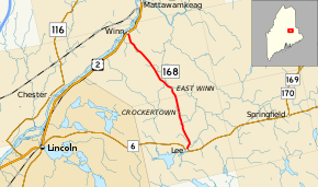
Maine State Route 168
State Route 168 (SR 168) is part of Maine's system of numbered state highways. It runs 10.2 miles (16.4 km) from an intersection with SR 6 in the town of Lee to U.S. Route 2 in Winn. It is known as Winn Road for its entire length.[2]
| ||||
|---|---|---|---|---|
| Winn Road | ||||
 | ||||
| Route information | ||||
| Maintained by MaineDOT | ||||
| Length | 10.19 mi[1] (16.40 km) | |||
| Existed | 1925–present | |||
| Major junctions | ||||
| South end | ||||
| North end | ||||
| Location | ||||
| Counties | Penobscot | |||
| Highway system | ||||
| ||||
Major junctions
The entire route is in Penobscot County.
| Location | mi[1] | km | Destinations | Notes | |
|---|---|---|---|---|---|
| Lee | 0.00 | 0.00 | |||
| Winn | 10.19 | 16.40 | |||
| 1.000 mi = 1.609 km; 1.000 km = 0.621 mi | |||||
gollark: Not quite the same.
gollark: Well, *rare*, not exclusive.
gollark: There is a *difference* between "1 in a 1000 or so once a month" and "1 in about 4 with actual significant involvement whenever you want".
gollark: NDs: trading, unofficial raffles/gifting, actually making one.CB Prizes: official raffles.Golds: market, cave.
gollark: The market's not random.
References
- "Maine DOT Map Viewer". Maine Office of GIS. Retrieved August 7, 2017.
- Google (August 7, 2017). "Maine State Route 168" (Map). Google Maps. Google. Retrieved August 7, 2017.
This article is issued from Wikipedia. The text is licensed under Creative Commons - Attribution - Sharealike. Additional terms may apply for the media files.
