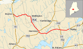
Maine State Route 154
State Route 154 (SR 154) is part of Maine's system of numbered state highways, located in Somerset and Piscataquis counties. It runs from Brighton to Ripley, and it is 20.2 miles (32.5 km) long.
| ||||
|---|---|---|---|---|
 | ||||
| Route information | ||||
| Maintained by MaineDOT | ||||
| Length | 20.17 mi[1] (32.46 km) | |||
| Major junctions | ||||
| West end | ||||
| East end | ||||
| Location | ||||
| Counties | Somerset, Piscataquis | |||
| Highway system | ||||
| ||||
Junction list
| County | Location | mi[1] | km | Destinations | Notes | |||
|---|---|---|---|---|---|---|---|---|
| Somerset | Brighton | 0.00 | 0.00 | Western terminus of SR 154 | ||||
| Piscataquis |
No major junctions | |||||||
| Somerset | Harmony | 10.59 | 17.04 | |||||
| Ripley | 17.32 | 27.87 | Western end of SR 152 concurrency | |||||
| 17.45 | 28.08 | Eastern end of SR 152 concurrency; Western end of SR 23 concurrency | ||||||
| 20.17 | 32.46 | Water Street | Eastern terminus of SR 154 at the intersection with Water Street; eastern end of SR 23 concurrency; road continues east as SR 23 | |||||
1.000 mi = 1.609 km; 1.000 km = 0.621 mi
| ||||||||
gollark: And I don't trust the government much either, because they tend to grow excessively and/or do stupid/powergrabby things.
gollark: I don't really trust "the aggregated opinion of the majority" to be remotely sensible.
gollark: People inevitably want to enforce whatever their particular bizarre views are on everyone, which causes badness and require systems which create more badness.
gollark: See, I personally support governments doing as little as possible because they cannot be trusted.
gollark: ++delete <@!330678593904443393> (authleft)
References
- Maine DOT Map Viewer (Map). Maine Office of GIS. Retrieved October 20, 2017.
External links
This article is issued from Wikipedia. The text is licensed under Creative Commons - Attribution - Sharealike. Additional terms may apply for the media files.
