Mae Suai District
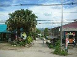
Mae Suai (Thai: แม่สรวย; IPA: [mɛ̂ː sǔaj]) is a district (amphoe) in the western part of Chiang Rai Province, northern Thailand.
Mae Suai แม่สรวย | |
|---|---|
 | |
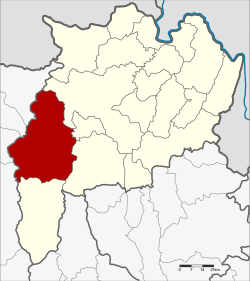 District location in Chiang Rai Province | |
| Coordinates: 19°39′23″N 99°32′33″E | |
| Country | Thailand |
| Province | Chiang Rai |
| Area | |
| • Total | 1,428.61 km2 (551.59 sq mi) |
| Population (2008) | |
| • Total | 82,989 |
| • Density | 56.3/km2 (146/sq mi) |
| Time zone | UTC+7 (ICT) |
| Postal code | 57180 |
| Geocode | 5710 |
Geography
Neighboring districts are (from the northeast clockwise): Mueang Chiang Rai, Mae Lao, Phan, Wiang Pa Pao, Phrao, Chai Prakan, Fang, and Mae Ai of Chiang Mai Province.
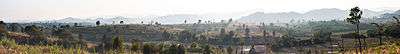
The Khun Tan Range stretches from north to south along the west side of the district. The Suai River, a tributary of the Lao River, gives its name to the district.
History
The district was created in 1905, when the districts Mueang Wiang Pa Pao and Mueang Phong were merged.[1] Originally spelled แม่ซ่วย, the current spelling was adopted before 1917.
Administration
Central administration
The district Mae Suai is subdivided into 7 subdistricts (Tambon), which are further subdivided into 131 administrative villages (Muban).
| No. | Name | Thai | Villages | Pop.[2] |
|---|---|---|---|---|
| 1. | Mae Suai | แม่สรวย | 17 | 9,432 |
| 2. | Pa Daet | ป่าแดด | 22 | 11,966 |
| 3. | Mae Phrik | แม่พริก | 13 | 5,650 |
| 4. | Si Thoi | ศรีถ้อย | 12 | 6,723 |
| 5. | Tha Ko | ท่าก๊อ | 28 | 18,468 |
| 6. | Wawi | วาวี | 27 | 25,476 |
| 7. | Chedi Luang | เจดีย์หลวง | 12 | 7,087 |
Local administration
There are 3 subdistrict municipalities (Thesaban Tambon) in the district:
- Mae Suai (Thai: เทศบาลตำบลแม่สรวย) consisting of parts of the subdistrict Mae Suai.
- Chedi Luang (Thai: เทศบาลตำบลเจดีย์หลวง) consisting of parts of the subdistrict Chedi Luang.
- Wiang Suai (Thai: เทศบาลตำบลเวียงสรวย) consisting of parts of the subdistrict Mae Suai.
There are 6 subdistrict administrative organizations (SAO) in the district:
- Pa Daet (Thai: องค์การบริหารส่วนตำบลป่าแดด) consisting of the complete subdistrict Pa Daet.
- Mae Phrik (Thai: องค์การบริหารส่วนตำบลแม่พริก) consisting of the complete subdistrict Mae Phrik.
- Si Thoi (Thai: องค์การบริหารส่วนตำบลศรีถ้อย) consisting of the complete subdistrict Si Thoi.
- Tha Ko (Thai: องค์การบริหารส่วนตำบลท่าก๊อ) consisting of the complete subdistrict Tha Ko.
- Wawi (Thai: องค์การบริหารส่วนตำบลวาวี) consisting of the complete subdistrict Wawi.
- Chedi Luang (Thai: องค์การบริหารส่วนตำบลเจดีย์หลวง) consisting of parts of the subdistrict Chedi Luang.
References
- แจ้งความกระทรวงมหาดไทย (PDF). Royal Gazette (in Thai). 22 (39): 950–951. 24 December 1905.
- "Population statistics 2018" (in Thai). Department of Provincial Administration. Retrieved 19 June 2020.
External links

- amphoe.com
Chiang Rai | ||
|---|---|---|
| Main article |  | |
| Capital city | ||
| Districts (amphoe) |
| |
| Related topics |
| |