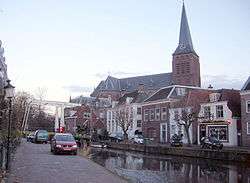
Maarssen
Maarssen (![]()
Maarssen | |
|---|---|
Town and former municipality | |
 | |
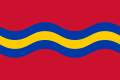 Flag  Coat of arms | |
 | |
| Coordinates: 52.135144°N 5.041297°E | |
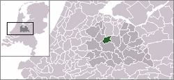
| Country | Netherlands |
| Province | Utrecht |
| Municipality | Stichtse Vecht |
| Area (2006) | |
| • Total | 30.86 km2 (11.92 sq mi) |
| • Land | 27.20 km2 (10.50 sq mi) |
| • Water | 3.66 km2 (1.41 sq mi) |
| Population (1 January, 2007) | |
| • Total | 39,363 |
| • Density | 1,447/km2 (3,750/sq mi) |
| Source: CBS, Statline. | |
| Time zone | UTC+1 (CET) |
| • Summer (DST) | UTC+2 (CEST) |
| Website | www.stichtsevecht.nl |
On January 1, 2011 Maarssen merged with the councils of Breukelen and Loenen to become Stichtse Vecht.
Population centres
The former municipality of Maarssen consisted of the following cities, towns, villages and/or districts:
- Maarssen (colloquially "Maarssen-dorp") and Maarssen-Broek
- Maarssenbroek
- Maarsseveen
- Molenpolder
- Oud-Maarsseveen
- Oud-Zuilen
- Tienhoven
Transportation
gollark: What a highly advanced code.
gollark: Why would they do hexadecimal anyway? Weird bug? To select for 1337 h4xx0rz?
gollark: Yes, all cool bots are created as jokes or to perform random tasks of no utility.
gollark: Hmm, battlekruiser seems to exist again, interesting.
gollark: I find that the messages in the really long bizarre conversations mostly lack humor value.
References
- Statistics are taken from the SDU Staatscourant Archived 2006-02-19 at the Wayback Machine
External links

- Official website
- Regio Maarssen
- Historische Kring Maarssen
- Maarssen 2000
| Authority control |
|
|---|
This article is issued from Wikipedia. The text is licensed under Creative Commons - Attribution - Sharealike. Additional terms may apply for the media files.