Mâcot-la-Plagne
Mâcot-la-Plagne is a former commune in the Savoie department in the Auvergne-Rhône-Alpes region in south-eastern France. On 1 January 2016, it was merged into the new commune of La Plagne-Tarentaise.[2]
Mâcot-la-Plagne | |
|---|---|
Part of La Plagne-Tarentaise | |
The ski station of La Plagne | |
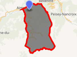
Location of Mâcot-la-Plagne 
| |
 Mâcot-la-Plagne  Mâcot-la-Plagne | |
| Coordinates: 45°33′16″N 6°40′22″E | |
| Country | France |
| Region | Auvergne-Rhône-Alpes |
| Department | Savoie |
| Arrondissement | Albertville |
| Canton | Bourg-Saint-Maurice |
| Commune | La Plagne-Tarentaise |
| Area 1 | 37.86 km2 (14.62 sq mi) |
| Population (2017)[1] | 1,697 |
| • Density | 45/km2 (120/sq mi) |
| Time zone | UTC+01:00 (CET) |
| • Summer (DST) | UTC+02:00 (CEST) |
| Postal code | 73210 |
| Elevation | 653–2,708 m (2,142–8,885 ft) (avg. 760 m or 2,490 ft) |
| 1 French Land Register data, which excludes lakes, ponds, glaciers > 1 km2 (0.386 sq mi or 247 acres) and river estuaries. | |
Geography
It gives its name to the French ski resort La Plagne, most of which lies within the commune of Mâcot-la-Plagne. It is bordered by the communes of Aime to the west, Bozel to the southwest, Champagny-en-Vanoise to the south, Bellentre to the east, and Valezan and La Côte-d'Aime to the north
Population
- 1962= 1072
- 1968= 1204
- 1975= 1112
- 1982= 1210
- 1990= 1621
- 1999= 1578
- 2006= 1789
gollark: The test can't self-test, because it's testing itself for what it was made to do.
gollark: I don't know. I don't think that's known. Do we even *have* ultimate goals.
gollark: Not really!
gollark: And that would, again, hand over power to the test designer.
gollark: I don't know if you actually can. You definitely can't tell *in advance* if they won't be.
See also
This article is issued from Wikipedia. The text is licensed under Creative Commons - Attribution - Sharealike. Additional terms may apply for the media files.