Lužnice (river)
The Lužnice (Czech pronunciation: [ˈluʒɲɪtsɛ] (![]()
| Lužnice | |
|---|---|
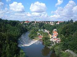 The Lužnice near Bechyně | |
_-_location_and_watershed_map.svg.png) 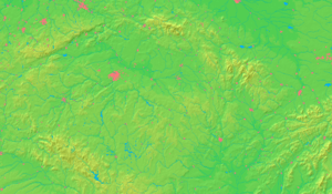 The Lužnice and its watershed until it enters the Vltava (magenta) | |
| Location | |
| Countries | |
| Cities | |
| Physical characteristics | |
| Source | |
| • location | Gratzen Mountains, Austria |
| • coordinates | 48°35′50.6″N 14°43′54″E |
| • elevation | 970 m (3,180 ft) |
| Mouth | Vltava |
• coordinates | 49°13′49.7″N 14°23′21″E |
| Length | 197.4 km (122.7 mi)[1] |
| Basin size | 4,226.2 km2 (1,631.7 sq mi) |
| Discharge | |
| • location | mouth |
| • average | 24.3 m3/s (860 cu ft/s) |
| Basin features | |
| Progression | Vltava→ Elbe→ North Sea |
| Tributaries | |
| • right | Nežárka |
The river was first mentioned in sources in the year 1179. The name was derived from an old Czech word for water flowing through meadows.
Several places on the river are popular destinations for recreation and canoeing.
Towns and cities on the Lužnice river
gollark: D:UltimateInductionCellMaxEnergy=5.12E11 D:UltimateInductionProviderOutput=3.2768E7
gollark: Okay then. Let me find the induction thingy capacity.
gollark: Well there you go.
gollark: (is completely useless since *you cannot do that*)
gollark: No, it has a limit imposed by mekanism itself.
References
- Niederösterreich Atlas (Lower Austria)
This article is issued from Wikipedia. The text is licensed under Creative Commons - Attribution - Sharealike. Additional terms may apply for the media files.