Luttrell Loop
The Toronto Transit Commission's Luttrell Loop was the eastern terminus of the Bloor streetcar line, until 1968, when the line was replaced by the Bloor–Danforth subway line.[1] Prior to the Prince Edward viaduct crossing the Don Valley, the Luttrell loop was the eastern terminus of a route that had its western terminus at Broadview Avenue.[2]
.jpg)
The Luttrell Loop had two arrangements. Until 1955, the loop crossed the south-west corner counter-clockwise. In 1955, a new larger loop opened where streetcars turned south on Kelvin Avenue, east on a private right-of way where a platform and waiting rooms were built, then north on Luttrell Avenue, and west on Danforth Avenue. Also, in 1955, the Main Loop was built on Main Street just north of Danforth Avenue to eliminate the congestion of having Carlton streetcars looping at the Luttrell Loop.[3][4]
Like the Jane Loop at the other end of the Bloor line, several local and intercity bus routes also terminated at the loop, allowing commuters to transfer between routes.
Luttrell Avenue, an otherwise obscure, tiny dead-end street, was (at the time the loop was in use) the eastern limit of the City of Toronto as it intersected with Danforth Avenue. The borders of the borough of East York dipped down south of the Danforth at this point to encompass the Ford Motor plant (later Shoppers World Danforth), which lay directly to the east of Luttrell.
References
-
Mike Filey (2008). Toronto: The Way We Were. Dundurn Press. p. 168. ISBN 9781550028423. Retrieved 2014-02-17.
Many long-time Torontonians will remember when streetcars—often in the form of so-called M-Us (multiple-units consisting of a pair of coupled PCC streamliners)—would shuttle between the two legendary streetcar loops, Jane on the west and Luttrell on the east. They were usually jammed to the doors. The Jane–Luttrell (or if you were headed in the other direction, Luttrell–Jane) service was introduced in the mid-1920s and remained in its entirety until the Bloor–Danforth subway opened in 1966.
-
Mike Filey (1997). The TTC Story: The First Seventy-five Years. Dundurn Press. p. 92. ISBN 9781770700796. Retrieved 2014-02-17.
To serve communities at the extremities of both Bloor Street and Danforth Avenue, the city constructed and operated two lines as part of its Civic Railways system. Bloor West operated between Dundas Street West and, ultimately, Runnymede Road; Danforth between Broadview and Luttrell avenues. With the creation of the Toronto Transportation Commission, these two "stub" lines were eventually merged into the cross-city route that followed Bloor Street and Danforth Avenue.
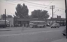
- R. McMann (May 1, 1966). "PCC 4664 pulls out of Luttrell loop". Transit Toronto. Retrieved 2017-02-19.
TTC ex-Cleveland all-electric PCC 4664 pulls out of Luttrell loop on its way back to Woodbine station as part of the DANFORTH shuttle on May 1, 1966. Photograph by R. McMann, from the John Knight collection.
- John F. Bromley and Jack May (1973). 50 Years of Progressive Transit. Electric Railroaders' Association. pp. 89. ISBN 9781550024487. Retrieved 2016-08-31.