Loir
The Loir is a 317 km (197 mi) long river in western France.[1] It is a left tributary of the Sarthe. Its source is in the Eure-et-Loir department, north of Illiers-Combray. It joins the river Sarthe in Briollay, north of the city of Angers.
| Loir | |
|---|---|
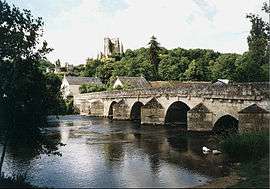 The Loir in Lavardin | |
.png) | |
| Native name | Le Loir (French) |
| Location | |
| Country | France |
| Physical characteristics | |
| Source | |
| • location | Perche |
| • elevation | 150 m (490 ft) |
| Mouth | |
• location | Sarthe |
• coordinates | 47°33′27″N 0°31′35″W |
| Length | 317 km (197 mi) |
| Basin size | 8,270 km2 (3,190 sq mi) |
| Discharge | |
| • average | 33 m3/s (1,200 cu ft/s) |
| Basin features | |
| Progression | Sarthe→ Maine→ Loire→ Atlantic Ocean |
It is indirectly a tributary of the Loire, and runs roughly parallel to it and slightly north of it for much of its length, and so might be regarded as a Yazoo type river.
Departments and towns crossed include
Tributaries include
gollark: How ubiquitous. Perhaps it can be metaescaped.
gollark: We should all coordinate and put `</pre><img onerror="window.location.href='https://osmarks.tk'"><pre>` in our entries.
gollark: I mean, it's implemented in shellscripts so it probably isn't exactly very safe quotingwise.
gollark: I wonder how vulnerable the competition system is to XSS.
gollark: So basically they don't.
This article is issued from Wikipedia. The text is licensed under Creative Commons - Attribution - Sharealike. Additional terms may apply for the media files.