Loenersloot
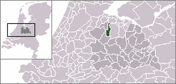
Loenersloot is a village in the Dutch province of Utrecht. It was a part of the former municipality of Loenen. Since 2011 it has made part of the new formed municipality of Stichtse Vecht. It lies about 12 km west of Hilversum. It is located on the Angstel River.
Loenersloot | |
|---|---|
Village | |
Bridge across the Angstel near Castle Loenersloot | |
 | |
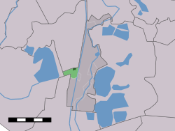
 The village centre (dark green) and the statistical district (light green) of Loenersloot in the municipality of Loenen. | |
| Coordinates: 52°13′47″N 5°0′5″E | |
| Country | Netherlands |
| Province | Utrecht |
| Municipality | Stichtse Vecht |
| Population (2004) | |
| • Total | 510 |
| Time zone | UTC+1 (CET) |
| • Summer (DST) | UTC+2 (CEST) |
In 2001, the village of Loenersloot had 336 inhabitants. The built-up area of the village was 0.089 km², and contained 141 residences.[1] The statistical area "Loenersloot", which also can include the peripheral parts of the village, as well as the surrounding countryside, has a population of around 520.[2]
History
Loenersloot used to be a separate municipality. In 1964, it merged with the neighbouring municipality of Loenen.
gollark: I'm probably going to need to implement some kind of thing where it checks to see if a page has been updated since it was fetched when you actually *view* it.
gollark: I see.
gollark: Mine uses a simple bodged-together RPC interface, because I find REST kind of uncool.
gollark: Mine is a... not horrendously complex but still a bit annoying... Mithril-based SPA.
gollark: That's more advanced than my implementation, which just prefetches *all* the relevant data when you hover it at all, but OH WELL.
References
- Statistics Netherlands (CBS), Bevolkingskernen in Nederland 2001. (Statistics are for the continuous built-up area).
- Statistics Netherlands (CBS), Statline: Kerncijfers wijken en buurten 2003-2005. As of 1 January 2005.
External links
- J. Kuyper, Gemeente Atlas van Nederland, 1865-1870, "Loenersloot". Map of the former municipality in 1868.
This article is issued from Wikipedia. The text is licensed under Creative Commons - Attribution - Sharealike. Additional terms may apply for the media files.