Loch Fell
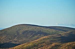
Loch Fell is a hill in the Ettrick Hills range, part of the Southern Uplands of Scotland. Close to the Southern Upland Way, routes of ascent frequently incorporate its track and it is almost always climbed along with the neighbouring hills.[4]
| Loch Fell | |
|---|---|
 | |
| Highest point | |
| Elevation | 688 m (2,257 ft) [1] |
| Prominence | 124 m (407 ft) [2] |
| Listing | Hu,Tu,Sim,D,GT,DN,Y [3] |
| Geography | |
| Location | Dumfries and Galloway, Scotland |
| Parent range | Ettrick Hills, Southern Uplands |
| OS grid | NT 17038 04730 |
| Topo map | OS Landranger 79 |
Subsidiary SMC Summits
| Summit | Height (m) | Listing[5] |
|---|---|---|
| West Knowe | 672 | Tu,Sim,DT,GT,DN[6] |
gollark: Join my server at osmarks.tk.
gollark: Not plugins.
gollark: Sorry, I mean mods.
gollark: Oh, and the many closed-source plugin edits are also anticompetitive.
gollark: People use those?
References
- https://www.hill-bagging.co.uk/mountaindetails.php?qu=S&rf=1869
- https://www.hill-bagging.co.uk/mountaindetails.php?qu=S&rf=1869
- http://www.hills-database.co.uk/database_notes.html#classification
- http://www.hill-bagging.co.uk/mountaindetails.php?qu=DN&rf=1869
- http://www.hills-database.co.uk/database_notes.html#classification
- http://www.hill-bagging.co.uk/mountaindetails.php?qu=S&rf=1880
This article is issued from Wikipedia. The text is licensed under Creative Commons - Attribution - Sharealike. Additional terms may apply for the media files.