Little Niangua River
The Little Niangua River is a 64.4-mile-long (103.6 km)[3] tributary of the Niangua River in the Ozarks region of central Missouri in the United States. Via the Niangua, Osage and Missouri rivers, it is part of the watershed of the Mississippi River. The Little Niangua was so named for its smaller size relative to the Niangua River.[4]
| Little Niangua River | |
|---|---|
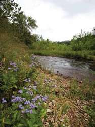 The Little Niangua River running through Fiery Fork Conservation Area. | |
| Location | |
| Country | United States |
| State | Missouri |
| Physical characteristics | |
| Source | |
| • location | Dallas County, Missouri |
| • coordinates | 37°44′55″N 93°01′15″W |
| • elevation | 1,179 ft (359 m) |
| Mouth | Lake of the Ozarks |
• location | Camden County, Missouri |
• coordinates | 38°04′17″N 92°54′24″W[1] |
• elevation | 663 ft (202 m) |
| Length | 64 mi (103 km) |
| Basin size | 320 sq mi (830 km2) |
| Discharge | |
| • location | USGS 06925250 near Macks Creek, MO[2] |
| • average | 150 cu ft/s (4.2 m3/s) |
| • minimum | 0 cu ft/s (0 m3/s) |
| • maximum | 6,730 cu ft/s (191 m3/s) |
| Basin features | |
| Watersheds | Little Niangua-Niangua-Osage-Missouri-Mississippi |
Description
The Little Niangua rises in Dallas County and flows generally northeasterly through Hickory and Camden counties. It joins the Niangua River in Camden County as an arm of the Lake of the Ozarks, which is formed by a dam on the Osage River.
Niangua darter
The upper reaches of the Little Niangua River, including the tributaries of Cahoochie Creek and Thomas Creek in Dallas County, are known habitats of the Niangua darter, a small fish that is on the U.S. Fish and Wildlife Service's list of Endangered Species.
Public areas
There are multiple river accesses on the Little Niangua River, including Bannister Hollow, Fiery Fork and most areas where a road crosses the river.
See also
- List of Missouri rivers
- Little Niangua Suspension Bridge
References
- "Little Niangua River". Geographic Names Information System. United States Geological Survey. Retrieved 2015-12-03.
- "Water-Data Report 2013 - Little Niangua River near Macks Creek, MO" (PDF). Retrieved 2015-12-03.
- U.S. Geological Survey. National Hydrography Dataset high-resolution flowline data. The National Map Archived 2012-03-29 at the Wayback Machine, accessed May 31, 2011
- "Hickory County Place Names, 1928–1945 (archived)". The State Historical Society of Missouri. Archived from the original on 24 June 2016. Retrieved 6 October 2016.CS1 maint: BOT: original-url status unknown (link)
- Columbia Gazetteer of North America entry
- DeLorme (2002). Missouri Atlas & Gazetteer. Yarmouth, Maine: DeLorme. ISBN 0-89933-353-2.
- U.S. Fish and Wildlife Service entry for the Niangua Darter
| Authority control |
|
|---|