Lister, British Columbia
Lister, British Columbia is a small community in the Kootenays region of British Columbia, Canada. It is located 10 miles (16 km) southeast of Creston and is just north of the Canada–US border.
Lister, British Columbia | |
|---|---|
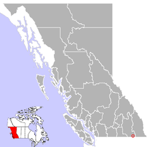 Location of Lister in British Columbia | |
| Coordinates: 49°03′00″N 116°28′00″W | |
| Country | |
| Province | |
| Region | Kootenays |
| Regional district | Central Kootenay |
| Time zone | UTC-7 (MST[1]) |
| Postal code span | V0B 1Y0 |
| Area code(s) | 250, 778 |
Originally known as Camp Lister, it was established by Colonel Fred Lister after World War I as a soldier's settlement. Fred Lister later became the MLA for the Nelson-Creston riding. The community's name officially changed to Lister on November 29, 1984.[2] Lister is the closest community to the Bountiful commune.
Climate
| Climate data for Lister (1981-2010) | |||||||||||||
|---|---|---|---|---|---|---|---|---|---|---|---|---|---|
| Month | Jan | Feb | Mar | Apr | May | Jun | Jul | Aug | Sep | Oct | Nov | Dec | Year |
| Record high °C (°F) | 12.0 (53.6) |
14.5 (58.1) |
23.0 (73.4) |
26.0 (78.8) |
33.0 (91.4) |
36.5 (97.7) |
38.0 (100.4) |
37.5 (99.5) |
36.0 (96.8) |
26.0 (78.8) |
16.5 (61.7) |
10.5 (50.9) |
38.5 (101.3) |
| Average high °C (°F) | 0.9 (33.6) |
3.4 (38.1) |
8.7 (47.7) |
14.4 (57.9) |
18.8 (65.8) |
22.4 (72.3) |
27.8 (82.0) |
27.6 (81.7) |
22.1 (71.8) |
13.1 (55.6) |
5.1 (41.2) |
0.5 (32.9) |
13.7 (56.7) |
| Daily mean °C (°F) | −1.9 (28.6) |
−0.3 (31.5) |
3.9 (39.0) |
8.5 (47.3) |
12.5 (54.5) |
16.0 (60.8) |
20.0 (68.0) |
19.7 (67.5) |
15.0 (59.0) |
8.0 (46.4) |
2.0 (35.6) |
−2.1 (28.2) |
8.4 (47.2) |
| Average low °C (°F) | −4.7 (23.5) |
−4.0 (24.8) |
−1.0 (30.2) |
2.6 (36.7) |
6.2 (43.2) |
9.6 (49.3) |
12.2 (54.0) |
11.8 (53.2) |
7.9 (46.2) |
3.0 (37.4) |
−1.1 (30.0) |
−4.8 (23.4) |
3.1 (37.7) |
| Record low °C (°F) | −26.5 (−15.7) |
−24.5 (−12.1) |
−16.5 (2.3) |
−5.0 (23.0) |
−2.0 (28.4) |
2.0 (35.6) |
4.5 (40.1) |
1.5 (34.7) |
−2.5 (27.5) |
−13.0 (8.6) |
−19.0 (−2.2) |
−27.5 (−17.5) |
−27.5 (−17.5) |
| Average precipitation mm (inches) | 57.0 (2.24) |
33.0 (1.30) |
42.3 (1.67) |
40.1 (1.58) |
69.3 (2.73) |
66.6 (2.62) |
37.2 (1.46) |
28.0 (1.10) |
31.5 (1.24) |
39.7 (1.56) |
68.0 (2.68) |
64.8 (2.55) |
577.5 (22.73) |
| Source: Environment Canada[3] | |||||||||||||
Notes
- Google Maps route between Lister and Creston
- "Lister". BC Geographical Names.
- Environment Canada—. Retrieved 29 November 2017.
gollark: I'm using the *same file*, served by `python3 -m http.server` and Warp's static file handling.
gollark: Okay, this is incredibly weird! Even when my server sends `audio/mp4` instead of `audio/m4a` in the headers, *Firefox still won't play it*!
gollark: WHAT DO YOU WANT FROM ME, FIREFOX
gollark: Hmm, so now it doesn't like `audio/m4a` either?!
gollark: In retrospect, this may have been a poor choice, and hi.
References
| Subdivisions |  | |
|---|---|---|
| Communities | ||
| Metro areas and agglomerations |
| |
| ||
This article is issued from Wikipedia. The text is licensed under Creative Commons - Attribution - Sharealike. Additional terms may apply for the media files.