List of protected heritage sites in Soumagne
This table shows an overview of the protected heritage sites in the Walloon town Soumagne. This list is part of Belgium's national heritage.
| Object |
Year/architect |
Town/section |
Address |
Coordinates |
Number? |
Image |
|---|---|---|---|---|---|---|
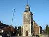
| Church of Saint-Lambert (nl) (fr) |
Soumagne | Soumagne | 50.612309°N 5.748051°E |
62099-CLT-0001-01 Info |
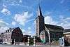 Kerk Saint-Lambert | |
| Former boundary stone "Belle Pierre" on the aqueduct of the stream, with the name "ruisseau du Pont Clory" (nl) (fr) |
Soumagne | 50.617218°N 5.764576°E |
62099-CLT-0002-01 Info |
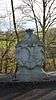 Voormalige grenssteen "Belle Pierre" op het aquaduct van de stroom, met de naam "ruisseau du Pont Clory" | ||
| Building (nl) (fr) |
Soumagne | rue Pierre Curie n°23 te Soumagne | 50.612077°N 5.747666°E |
62099-CLT-0003-01 Info |
||
| House (nl) (fr) |
Soumagne | chaussée de Liège n°87 te Ayeneux | 50.608493°N 5.714013°E |
62099-CLT-0004-01 Info |
||
| Church of Cerexhe-Heuseux (nl) (fr) |
Soumagne | 50.650465°N 5.729302°E |
62099-CLT-0005-01 Info |
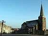 Kerk van Cerexhe-Heuseux | ||
| The old linden tree in the shade of the old chapel of Evegnée (nl) (fr) |
Soumagne | 50.641835°N 5.707439°E |
62099-CLT-0006-01 Info |
.JPG) De oude linde in de schaduw van de oude kapel van Evegnée | ||
| Chapel of Notre Dame (nl) (fr) |
Soumagne | Evegnée | 50.642024°N 5.707659°E |
62099-CLT-0007-01 Info |
 Kapel Notre-Dame | |
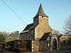
| Church of Saint-Job, furniture, organs, and the convent wall around the cemetery (nl) (fr) |
Soumagne | Melen | 50.646660°N 5.736595°E |
62099-CLT-0008-01 Info |
 Kerk Saint-Job, meubels, orgels en de kloostermuur rond het kerkhof | |
| ridge (pont) in 1677 behind the choir of the church of Soumagne (nl) (fr) |
Soumagne | Soumagne | 50.612523°N 5.749513°E |
62099-CLT-0011-01 Info |
||
| Part of the wall that surrounds the cemetery at the Church of Saint-Lambert, built in stone with crosses and embedded calvary and the disused cemetery (which is now converted into a public park) (nl) (fr) |
Soumagne | 50.612115°N 5.748137°E |
62099-CLT-0012-01 Info |
|||
| The "Belle Fleur" (nl) (fr) |
Soumagne | Soumagne | 50.619315°N 5.738006°E |
62099-CLT-0014-01 Info |
 De "Belle Fleur" | |
| Farmhouse (nl) (fr) |
Soumagne | rue Rafhay n°75 (jadis n°39) te Haute-Rafhay te savoir | 50.602412°N 5.752940°E |
62099-CLT-0016-01 Info |
See also
- List of protected heritage sites in Liège (province)
- Soumagne
| Wikimedia Commons has media related to Cultural heritage monuments in Soumagne. |
References
- Belgian heritage register: Direction générale opérationnelle - Aménagement du territoire, Logement, Patrimoine et Energie (DG4)
- www.dglive.be
This article is issued from Wikipedia. The text is licensed under Creative Commons - Attribution - Sharealike. Additional terms may apply for the media files.