List of protected heritage sites in Malmedy
This table shows an overview of the protected heritage sites in the Walloon town Malmedy. This list is part of Belgium's national heritage.
| Object |
Year/architect |
Town/section |
Address |
Coordinates |
Number? |
Image |
|---|---|---|---|---|---|---|
| Royal Atheneum of Malmedy: old Saint-Pierre-et-Paul facades, roofs, interior of the monastery, vaulted ceilings, chapter house,pillared in the northeast corner (nl) (fr) |
Malmedy | place du Châtelet | 50.428028°N 6.027257°E |
63049-CLT-0001-01 Info |
 Koninklijk Atheneum van Malmedy: oude abdij van Saints-Pierre-et-Paul: gevels, daken, interieur van het klooster, gewelfde plafonds, kapittelzaal, zuilenhal in de noordoostelijke hoek | |
| Chapel of the Resurrection (nl) (fr) |
Malmedy | place du Pont Neuf | 50.425221°N 6.033405°E |
63049-CLT-0002-01 Info |
 Kapel van Résurrection | |
| Six of the beech trees in the forest Fagne de Longlou (nl) (fr) |
Malmedy | 50.485627°N 6.024951°E |
63049-CLT-0003-01 Info |
.jpg) Zes beuken van de open plek van het bos van Fagne de Longlou | ||
| obelisk (nl) (fr) |
Malmedy | 50.425623°N 6.029004°E |
63049-CLT-0004-01 Info |
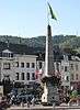 Obelisk | ||
| ravine (nl) (fr) |
Malmedy | 50.422657°N 6.042918°E |
63049-CLT-0005-01 Info |
|||
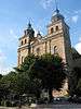
| Cathedral of Saints-Pierre-et-Paul et Saint-Quirin (nl) (fr) |
Malmedy | 50.426813°N 6.027824°E |
63049-CLT-0006-01 Info |
 Kathedraal Saints-Pierre-et-Paul et Saint-Quirin | ||
| Building: the former seat of the Fondation Cavens: facade, roof and side walls (nl) (fr) |
Malmedy | Place de Rome | 50.426196°N 6.025037°E |
63049-CLT-0009-01 Info |
 Gebouw: voormalige zetel van de Fondation Cavens: gevel, daken en zijgevels | |
| Church of Saint-Aubin and the church, its cemetery and surrounding wall (nl) (fr) |
Malmedy | 50.391774°N 6.012065°E |
63049-CLT-0010-01 Info |
 Kerk Saint-Aubin en het ensemble van de kerk, de begraafplaats er omheen en de omliggende muur | ||
| House "Maraite" (nl) (fr) |
Malmedy | n°11 | 50.390593°N 6.008122°E |
63049-CLT-0011-01 Info |
.jpg) Huis "Maraite" | |
| Ancient oak called "Lu Tchâne à Tchâne" (nl) (fr) |
Malmedy | 50.481554°N 6.078875°E |
63049-CLT-0012-01 Info |
.jpg) Eeuwenoude eik genaamd "Lu Tchâne à Tchâne" | ||
| Chapel of Saint Hubert (nl) (fr) |
Malmedy | 50.366415°N 6.037969°E |
63049-CLT-0013-01 Info |
|||
| Chapel of Saint Hubert and surroundings (nl) (fr) |
Malmedy | 50.366565°N 6.037591°E |
63049-CLT-0014-01 Info |
|||
| Farmhouse: half-timbered gables (nl) (fr) |
Malmedy | place du Hameau, Xhoffraix | 50.459207°N 6.068416°E |
63049-CLT-0015-01 Info |
||
| Massif of the juniper berries in a place called "Les Planeresses" (nl) (fr) |
Malmedy | 50.480997°N 6.080640°E |
63049-CLT-0016-01 Info |
 Massief van de jeneverbessen op een plek genaamd "Les Planeresses" | ||
| The hermitage of Bernister and its surroundings (nl) (fr) |
Malmedy | 50.441310°N 6.024704°E |
63049-CLT-0018-01 Info |
|||
| Chapel of Saint-François or Capucins (nl) (fr) |
Malmedy | ruelle des Capucins | 50.424752°N 6.030526°E |
63049-CLT-0019-01 Info |
||
| The rocks of Warche (nl) (fr) |
Malmedy | 50.387717°N 5.984576°E |
63049-CLT-0020-01 Info |
.jpg) De rotsen van Warche en instelling beschermingszone | ||
| House: Maison Villers and walls and roofs, and the gardens (nl) (fr) |
Malmedy | Cheminrue n° 11 | 50.425064°N 6.027795°E |
63049-CLT-0021-01 Info |
 Huis: Maison Villers (totaal) en aanbouw (gevels en daken) en het ensemble van de gebouwen en de tuin | |
| Notre Dame des Malades chapel, formerly Sainte-Marie-Madeleine, facades and roofs (nl) (fr) |
Malmedy | rue de la Chapelle | 50.425378°N 6.021877°E |
63049-CLT-0024-01 Info |
 Kapel Notre Dame des Malades, voorheen Sainte-Marie-Madeleine, gevels en daken | |
| Station annotinum Lycopodium L. van Wolfbusch, along the road to Ligneuville (nl) (fr) |
Malmedy | 50.373385°N 6.091116°E |
63049-CLT-0026-01 Info |
|||
| Facades and roofs of the old Hall of Gretedar (nl) (fr) |
Malmedy | rue de Grétedar n° 8 | 50.426250°N 6.030845°E |
63049-CLT-0028-01 Info |
 Gevels en daken van de oude halle de Grétedar, uitgezonderd de recente aanbouw in de noordoostelijke hoek, instelling beschermingszone | |
| Fischbach Chapel (nl) (fr) |
Malmedy | 50.518242°N 6.063138°E |
63049-CLT-0030-01 Info |
.JPG) Kapel Fischbach | ||
| Historic area of the municipalities Jalhay, Baelen, Waimes and Malmedy (nl) (fr) |
Malmedy | 50.525604°N 6.044209°E |
63049-CLT-0031-01 Info |
|||
| Reinhardstein Castle and the valley of the Warche (nl) (fr) |
Malmedy | 50.447729°N 6.079665°E |
63049-CLT-0032-01 Info |
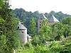 Ensemble van kasteel van Reinhardstein en de vallei van de Warche | ||
| Villers house, except the rear and extension to the courtyard (nl) (fr) |
Malmedy | 50.425064°N 6.027795°E |
63049-PEX-0001-01 Info |
See also
- List of protected heritage sites in Liège (province)
- Malmedy
| Wikimedia Commons has media related to Cultural heritage monuments in Malmedy. |
References
- Belgian heritage register: Direction générale opérationnelle - Aménagement du territoire, Logement, Patrimoine et Energie (DG4)
- www.dglive.be
This article is issued from Wikipedia. The text is licensed under Creative Commons - Attribution - Sharealike. Additional terms may apply for the media files.