List of protected heritage sites in Geer
This table shows an overview of the protected heritage sites in the Walloon town Geer. This list is part of Belgium's national heritage.
| Object |
Year/architect |
Town/section |
Address |
Coordinates |
Number? |
Image |
|---|---|---|---|---|---|---|
| Castle Boëlhe, the wooded park and its surroundings (nl) (fr) |
Geer | 50.683178°N 5.162868°E |
64029-CLT-0002-01 Info |
|||
| Chapel of the "Crucifix of Darion" (nl) (fr) |
Geer | 50.665940°N 5.189369°E |
64029-CLT-0004-01 Info |
|||
| Church of Saint-Brice (nl) (fr) |
Geer | Hollogne | 50.673714°N 5.213929°E |
64029-CLT-0006-01 Info |
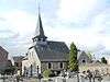 Kerk Saint-Brice | |
| chapel crucifix & surrounding land (nl) (fr) |
Geer | Hollogne-sur-Geer | 50.668895°N 5.219206°E |
64029-CLT-0007-01 Info |
||
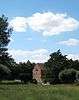
| Remains of the old mansion of Hollogne-sur-Geer (nl) (fr) |
Geer | 50.675506°N 5.210165°E |
64029-CLT-0008-01 Info |
_IMG_1059.JPG) Ensemble van de overblijfselen van het oude landhuis van Hollogne-sur-Geer | ||
| Old house (nl) (fr) |
Geer | rue du Centre n°24 | 50.675558°N 5.211046°E |
64029-CLT-0009-01 Info |
||
| Watermill on the banks of the Geer (nl) (fr) |
Geer | Hollogne-sur-Geer | 50.675263°N 5.209288°E |
64029-CLT-0010-01 Info |
 Watermolen aan de oever van de Geer | |
| Place called "Entre les Tiges" with chapel (nl) (fr) |
Geer | Geer | 50.656951°N 5.175633°E |
64029-CLT-0012-01 Info |
_IMG_1097.JPG) Plaats genaamd "Entre les Tiges" met kapel | |
| Building called "Refuge Fortifie" (nl) (fr) |
Geer | 50.655414°N 5.198169°E |
64029-CLT-0013-01 Info |
|||
| "Refuge Fortifie" fortified refuge and its environment (nl) (fr) |
Geer | Omal | 50.656214°N 5.195687°E |
64029-CLT-0014-01 Info |
||
| Omal house (nl) (fr) |
Geer | 50.656406°N 5.197806°E |
64029-CLT-0016-01 Info |
 Herenhuis van Omal | ||
| Tumulus of Omal (1 of 5 "tumuli") (nl) (fr) |
Geer | 50.651050°N 5.198594°E |
64029-CLT-0017-01 Info |
.JPG) Tumuli van Omal, het ensemble van vijf tumuli en diens omgeving | ||
| Boëlhe Castle: walls and roofs, and painted walls (oil on canvas) of one room (nl) (fr) |
Geer | 50.684182°N 5.167134°E |
64029-CLT-0018-01 Info |
|||
| Seny house, full fencing and pillars, the facades and roofs of the main house, stables, barn and wing (nl) (fr) |
Geer | rue d'Abolens n°23 | 50.681745°N 5.163938°E |
64029-CLT-0019-01 Info |
||
| Farm: walls and roofs, and the interior of the dovecote, the sheepfold, the north wing with the original furnishings, and surroundings (nl) (fr) |
Geer | 50.676501°N 5.207415°E |
64029-CLT-0020-01 Info |
|||
| Motte (of Motte-and-bailey) (nl) (fr) |
Geer | Geer | 50.657221°N 5.196076°E |
64029-CLT-0021-01 Info |
||
| Tumulus of Omal (1 of 5 "tumuli") (nl) (fr) |
Geer | chaussée romaine Boulogne-Bavay-Cologne (Roman road) | 50.650494°N 5.197921°E |
64029-CLT-0022-01 Info |
Tumuli van Omal aan de Romeinse weg Boulogne-Bavay-Keulen, beschermingszone | |
| Tumulus of Omal (archeological site) (nl) (fr) |
Geer | 50.651328°N 5.197991°E |
64029-PEX-0001-01 Info |
Tumuli van Omal, de archeologische site van vijf tumuli genaamd "Les cinq tombes" |
See also
- List of protected heritage sites in Liège (province)
- Geer
| Wikimedia Commons has media related to Cultural heritage monuments in Geer. |
References
- Belgian heritage register: Direction générale opérationnelle - Aménagement du territoire, Logement, Patrimoine et Energie (DG4)
- www.dglive.be
This article is issued from Wikipedia. The text is licensed under Creative Commons - Attribution - Sharealike. Additional terms may apply for the media files.