List of protected heritage sites in Durbuy
This table shows an overview of the protected heritage sites in the Walloon town Durbuy. This list is part of Belgium's national heritage.
| Object |
Year/architect |
Town/section |
Address |
Coordinates |
Number? |
Image |
|---|---|---|---|---|---|---|
| The Grain Exchange or Spanish house (nl) (fr) |
Durbuy | Durbuy | 50.352104°N 5.456216°E |
83012-CLT-0001-01 Info |
.JPG) De graanbeurs of Spaans huis | |
| The century-old beech tree at a place called "Haie des Veaux" (nl) (fr) |
Durbuy | Durbuy | 50.346340°N 5.446606°E |
83012-CLT-0002-01 Info |
||
| The facades and roofs of buildings (vicarage) (nl) (fr) |
Durbuy | rue des Récollets n°38, Durbuy | 50.352912°N 5.456711°E |
83012-CLT-0003-01 Info |
||
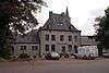
| The facades and roofs of the castle of Bomal (nl) (fr) |
Durbuy | Durbuy | 50.376262°N 5.521730°E |
83012-CLT-0005-01 Info |
||
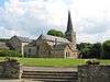
| Notre Dame (nl) (fr) |
Durbuy | Borlon | 50.379222°N 5.404748°E |
83012-CLT-0007-01 Info |
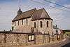 Kerk Notre-Dame | |
| Wall around the cemetery of the church of Notre-Dame (nl) (fr) |
Durbuy | Durbuy | 50.379136°N 5.404845°E |
83012-CLT-0008-01 Info |
||
| The old tower, called Justice annexed to the castle of Grandhan (nl) (fr) |
Durbuy | Grandhan | 50.329732°N 5.408607°E |
83012-CLT-0010-01 Info |
 De oude toren, genaamd Justitie, gehecht aan het kasteel van Grandhan | |
| Church of Sainte-Marguerite and the wall of the cemetery of Adrienne Illes, and the ensemble of the church, cemetery and surrounding wall (nl) (fr) |
Durbuy | Granhan | 50.317078°N 5.378623°E |
83012-CLT-0011-01 Info |
 Kerk Sainte-Marguerite en de muur van het kerkhof van Enneilles, en het ensemble van de kerk, kerkhof en omgeving | |
| Two lime trees in the locality "Chêne-à-Han", at the intersection of the road and that of Somme-Leuze Enneille-Lamarteau (nl) (fr) |
Durbuy | Grandhan | 50.331732°N 5.390026°E |
83012-CLT-0012-01 Info |
||
| Tower, the walls and roofs of the main building of the castle of Izier, and the ensemble of the tower, main building, the farmhouse and courtyard, and the plot next to the gate of the buildings (nl) (fr) |
Durbuy | 50.383462°N 5.580395°E |
83012-CLT-0013-01 Info |
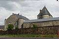 Toren, de muren en daken van het hoofdgebouw van de kasteelhoeve van Izier, en het ensemble van de toren, het hoofdgebouw, de boerderij en de binnenplaats, en het perceel naast de poort van de gebouwen | ||
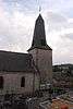
| St. Martin's Church (nl) (fr) |
Durbuy | Tohogne | 50.380183°N 5.480436°E |
83012-CLT-0014-01 Info |
 Kerk Saint-Martin | |
| Chapel (unused) (nl) (fr) |
Durbuy | place Vendôme, rechts van n°44 | 50.401702°N 5.512135°E |
83012-CLT-0015-01 Info |
||
| Building in Tohogne (nl) (fr) |
Durbuy | rue de Presseux | 50.381271°N 5.479585°E |
83012-CLT-0017-01 Info |
||
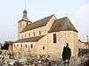
| Church Sainte Walburge (nl) (fr) |
Durbuy | Wéris | 50.326551°N 5.530436°E |
83012-CLT-0018-01 Info |
 Kerk Sainte Walburge | |
| Dolmens in the territory of the village Wéris (nl) (fr) |
Durbuy | Wéris | 50.333377°N 5.522700°E |
83012-CLT-0019-01 Info |
.jpg) Dolmens op het grondgebied van het dorp Wéris | |
| Ensemble of the church and the fortified house of Wéris (nl) (fr) |
Durbuy | Wéris | 50.326428°N 5.529827°E |
83012-CLT-0020-01 Info |
||
| Oldest parts of the city walls (nl) (fr) |
Durbuy | Durbuy | 50.352040°N 5.457713°E |
83012-CLT-0022-01 Info |
||
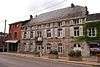
| The facades and roofs of the house Legros (nl) (fr) |
Durbuy | Durbuy | 50.350941°N 5.493804°E |
83012-CLT-0023-01 Info |
 De gevels en daken van het huis Legros | |
| The facades and roofs of the chapel in M. Paridaens, and the panels in the interior of the building, and the ensemble of the chapel and its surroundings (nl) (fr) |
Durbuy | Durbuy | 50.419313°N 5.414682°E |
83012-CLT-0024-01 Info |
||
| Chapel of Saint-Denis (nl) (fr) |
Durbuy | Juzaine | 50.370250°N 5.534069°E |
83012-CLT-0026-01 Info |
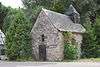 Kapel Saint-Denis | |
| The facades and roofs of the building "La Poivrière" (nl) (fr) |
Durbuy | Grand-Rue n°28, Durbuy | 50.350667°N 5.494417°E |
83012-CLT-0027-01 Info |
 De gevels en daken van het gebouw "La Poivrière" | |
| Old Manse: facades and roofs (nl) (fr) |
Durbuy | rue de Liège, links van n°29 | 50.379125°N 5.523317°E |
83012-CLT-0028-01 Info |
||
| Mont Saint Rahy (nl) (fr) |
Durbuy | Bomal | 50.384403°N 5.541104°E |
83012-CLT-0029-01 Info |
||
| The "Grandes Roches" (nl) (fr) |
Durbuy | Bomal | 50.377741°N 5.528943°E |
83012-CLT-0030-01 Info |
||
| Ensemble of the chapel of Sainte-Geneviève, the linden trees and grassland around them (nl) (fr) |
Durbuy | Izier | 50.382415°N 5.587560°E |
83012-CLT-0031-01 Info |
||
| The "Longue Haye", including the country road called "Voye du Juzaine" and the two towns called "Calvary" and "Longue Haye" (nl) (fr) |
Durbuy | Ozo | 50.368501°N 5.538140°E |
83012-CLT-0035-01 Info |
||
| The facades and roofs of the building (Institut Clairval) (nl) (fr) |
Durbuy | rue des Récollets n°39, Durbuy | 50.353131°N 5.457000°E |
83012-CLT-0036-01 Info |
||
| Old Grain Exchange (nl) (fr) |
Durbuy | 50.352104°N 5.456216°E |
83012-PEX-0001-01 Info |
|||
| Murals from the 16th and 17th centuries of the church of Saint-Martin (nl) (fr) |
Durbuy | Tohogne | 50.380183°N 5.480436°E |
83012-PEX-0002-01 Info |
||
| The northern Dolmen (nl) (fr) |
Durbuy | Wéris | 50.333377°N 5.522700°E |
83012-PEX-0003-01 Info |
See also
- List of protected heritage sites in Luxembourg (Belgium)
- Durbuy
| Wikimedia Commons has media related to Cultural heritage monuments in Durbuy. |
References
- Belgian heritage register: Direction générale opérationnelle - Aménagement du territoire, Logement, Patrimoine et Energie (DG4)
- www.dglive.be