List of protected heritage sites in Binche
This table shows an overview of the protected heritage sites in the Walloon town Binche. This list is part of Belgium's national heritage.
| Object |
Year/architect |
Town/section |
Address |
Coordinates |
Number? |
Image |
|---|---|---|---|---|---|---|
| Old walls of Binche (nl) (fr) |
Binche | 50.414880°N 4.168351°E |
56011-CLT-0001-01 Info |
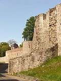 Oude wallen van Binche | ||
| Building called "Maison Bette", has become a haven for former Abbey of Good Hope, called "Caves Bettes" (nl) (fr) |
Binche | rue des Promenades | 50.409103°N 4.166264°E |
56011-CLT-0003-01 Info |
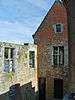 Gebouw genaamd "Maison Bette", uitgegroeid tot een toevluchtsoord voor voormalige abdij van Goede Hoop, de zogenaamde "Caves Bettes" | |
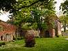
| Ruins of castle Marie de Hongrie, municipal park (nl) (fr) |
Binche | 50.408367°N 4.164737°E |
56011-CLT-0005-01 Info |
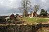 Ruïnes van kasteel Marie de Hongrie, sectionlijk park | ||
| Chapel of the old cemetery (nl) (fr) |
Binche | rue Haute | 50.409130°N 4.164154°E |
56011-CLT-0006-01 Info |
 Kapel van de oude begraafplaats | |
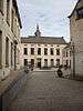
| town hall (nl) (fr) |
Binche | Grand Place | 50.410657°N 4.165580°E |
56011-CLT-0007-01 Info |
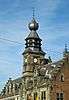 Raadhuis | |
| Chapel of Sainte-Anne Nies surplus (nl) (fr) |
Binche | rue Z. Fontaine | 50.417254°N 4.169172°E |
56011-CLT-0008-01 Info |
Kapel Sainte-Anne van Batignies | |
| Church of Saint-Ursmer (nl) (fr) |
Binche | 50.409033°N 4.165087°E |
56011-CLT-0009-01 Info |
 Kerk Saint-Ursmer | ||
| The buildings formerly used by the Royal Athenaeum (now the Museum of Carnival and Mask (formerly the Augustinian College)) (nl) (fr) |
Binche | rue de l'église n°16 | 50.409444°N 4.166053°E |
56011-CLT-0011-01 Info |
 De gebouwen vroeger benut door het Koninklijk Atheneum (nu het Museum van Carnaval en het Masker (voorheen de Augustijner College)) | |
| Castle Prisches and the ensemble of the castle and its immediate surroundings (nl) (fr) |
Binche | rue de Prisches n°s 7-8 | 50.405595°N 4.187390°E |
56011-CLT-0013-01 Info |
||
| House: main facade and front roof (nl) (fr) |
Binche | rue de Mons n°7 | 50.412506°N 4.165561°E |
56011-CLT-0014-01 Info |
||
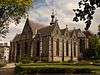
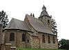
| Church Sainte-Elisabeth (nl) (fr) |
Binche | 50.412515°N 4.167026°E |
56011-CLT-0015-01 Info |
.jpg) Kerk Sainte-Elisabeth | ||
| Palace of Justice (nl) (fr) |
avenue Albert Ier, n°56 Binche | 50.412934°N 4.166198°E |
56011-CLT-0016-01 Info |
.jpg) Justitieel Paleis | ||
| Station Square Eugene Derbaix (nl) (fr) |
Binche | 50.409108°N 4.171814°E |
56011-CLT-0017-01 Info |
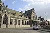 Station en plein Eugène Derbaix | ||
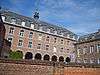
| Former nursing home, currently administrative center (facades and roofs) and environment (nl) (fr) |
Binche | rue Saint-Paul n°14 | 50.409924°N 4.166570°E |
56011-CLT-0018-01 Info |
 Voormalige verpleeghuis, op dit moment administratief centrum (gevels en daken) en omgeving | |
| Sainte-Marie (nl) (fr) |
Binche | 50.435815°N 4.145424°E |
56011-CLT-0019-01 Info |
|||
| Sainte-Marie-Madeleine (nl) (fr) |
Binche | 50.403416°N 4.204346°E |
56011-CLT-0022-01 Info |
 Kerk Sainte-Marie-Madeleine | ||
| Windmill "Moulin Stocklet" and its surroundings (nl) (fr) |
Binche | 50.422666°N 4.229020°E |
56011-CLT-0023-01 Info |
|||
| Mill Stocket and existing mechanism (nl) (fr) |
Binche | 50.422698°N 4.230102°E |
56011-CLT-0024-01 Info |
|||
| Old quarries Hubaut (nl) (fr) |
Binche | 50.409456°N 4.159077°E |
56011-CLT-0025-01 Info |
|||
| Archaeological site Vodgoriacum (nl) (fr) |
Binche | 50.417841°N 4.144313°E |
56011-CLT-0026-01 Info |
|||
| Of the old colliery spoil heaps of Courte (No. 160, "Fosse No. 1 Est", n ° 161, "Lavoir-Ressaix 's 162 et n ° 163" Leval ") (nl) (fr) |
Binche | 50.418461°N 4.198503°E |
56011-CLT-0027-01 Info |
|||
| Certain parts of the sorting and washing "Lavoir du Centre" (nl) (fr) |
Binche | rue des Mineurs 31 | 50.427604°N 4.172587°E |
56011-CLT-0030-01 Info |
||
| Pharmacy Milet: street facade and roof (nl) (fr) |
Binche | 50.411890°N 4.165440°E |
56011-CLT-0034-01 Info |
|||
| Possible classification of the church of Notre-Dame du Travail, and establishing a protection zone exists around the Place du Levant (nl) (fr) |
Binche | place du Levant van Mons naar Bray | 50.43136°N 4.06734°E |
56011-CLT-0035-01 Info |
||
| Old walls of Binche (nl) (fr) |
Binche | 50.414880°N 4.168351°E |
56011-PEX-0001-01 Info |
.jpg) Oude wallen van Binche | ||
| Town hall (nl) (fr) |
Binche | 50.410657°N 4.165580°E |
56011-PEX-0002-01 Info |
See also
- List of protected heritage sites in Hainaut (province)
- Binche
| Wikimedia Commons has media related to Cultural heritage monuments in Binche. |
References
- Belgian heritage register: Direction générale opérationnelle - Aménagement du territoire, Logement, Patrimoine et Energie (DG4)
- www.dglive.be
This article is issued from Wikipedia. The text is licensed under Creative Commons - Attribution - Sharealike. Additional terms may apply for the media files.