List of protected heritage sites in Bastogne
This table shows an overview of the protected heritage sites in the Walloon town Bastenaken, or Bastogne. This list is part of Belgium's national heritage.
| Object |
Year/architect |
Town/section |
Address |
Coordinates |
Number? |
Image |
|---|---|---|---|---|---|---|
| Gate of Trier (nl) (fr) |
Bastenaken | place de la Porte de Trèves | 50.004950°N 5.722052°E |
82003-CLT-0001-01 Info |
 Poort van Trier | |
| Church of Saint-Pierre (nl) (fr) |
Bastenaken | Bastogne | 50.004932°N 5.721444°E |
82003-CLT-0003-01 Info |
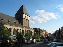 Kerk Saint-Pierre | |
| Ensemble of the Mardasson hill and its surroundings (nl) (fr) |
Bastenaken | Bastogne | 50.008874°N 5.728955°E |
82003-CLT-0005-01 Info |
 Ensemble van de heuvel van Mardasson en zijn directe omgeving | |
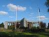
| Old choir of the Church of Bourcy (Longvilly) (nl) (fr) |
Bastenaken | 50.059732°N 5.807294°E |
82003-CLT-0007-01 Info |
|||
| The rectory of Rachamps and the ensemble of the Presbytery, the church and surrounding grounds (nl) (fr) |
Bastenaken | Bastogne | 50.084289°N 5.787824°E |
82003-CLT-0008-01 Info |
||
| Washing place of Rachamps (nl) (fr) |
Bastenaken | Bastogne | 50.083835°N 5.787167°E |
82003-CLT-0009-01 Info |
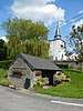 Wasplaats van Rachamps | |
| Romanesque tower and nave of three bays, followed by a polygonal apse into three parts, which goes back to the church of Saint-Lambert from 1723 (nl) (fr) |
Bastenaken | Rachamps | 50.083858°N 5.787878°E |
82003-CLT-0010-01 Info |
||
| Chapel of Saint-Cunibert (nl) (fr) |
Bastenaken | Bizory | 50.019337°N 5.765964°E |
82003-CLT-0011-01 Info |
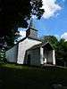 Kapel van Saint-Cunibert | |
| Harzy Chapel (now Chapel of the Holy Guardian Angels (Saints-Anges caretakers')) and the churchyard wall that surrounds it, and the ensemble of the chapel and surrounding cemetery wall (nl) (fr) |
Bastenaken | Bastogne | 49.993881°N 5.795047°E |
82003-CLT-0012-01 Info |
 Kapel van Harzy (nu Kapel van de Heilige Engelbewaarders('Saints-Anges Gardiens')) en de kerkhofmuur die het omringt, en het ensemble van de kapel en de omliggende kerkhofmuur | |
| Chapel of Saint-Laurent (nl) (fr) |
Bastenaken | Bastogne | 50.008768°N 5.717235°E |
82003-CLT-0013-01 Info |
 Kapel Saint-Laurent | |
| The facades and roofs of the farmhouse Didier Lamborelle (nl) (fr) |
Bastenaken | Benonchamps n°18, Bastogne | 50.003836°N 5.809712°E |
82003-CLT-0015-01 Info |
 De gevels en daken van de boerderij Didier of Lamborelle | |
| The facades and roofs of the main building of the farm, and the ensemble e vand farm, chapel and surrounding grounds (nl) (fr) |
Bastenaken | Grand-Route n°6, Bizory | 50.018992°N 5.765269°E |
82003-CLT-0016-01 Info |
||
| The facades and roofs of the chapel Notre-Dame de Bonne conduite, and the ensemble of the building and the environment (nl) (fr) |
Bastenaken | 49.990110°N 5.722432°E |
82003-CLT-0017-01 Info |
 De gevels en daken van de kapel Notre-Dame de Bonne Conduite, en het ensemble van het gebouw en de omgeving | ||
| The totality of the chapel Notre-Dame de la Paix (nl) (fr) |
Bastenaken | Bastogne | 50.002961°N 5.718019°E |
82003-CLT-0018-01 Info |
||
| Gate of Trier (nl) (fr) |
Bastenaken | 50.004950°N 5.722052°E |
82003-PEX-0001-01 Info |
Poort van Trier | ||
| Church of Saint-Pierre (nl) (fr) |
Bastenaken | 50.004932°N 5.721444°E |
82003-PEX-0002-01 Info |
Kerk Saint-Pierre |
See also
- List of protected heritage sites in Luxembourg (Belgium)
- Bastogne
| Wikimedia Commons has media related to Cultural heritage monuments in Bastogne. |
References
- Belgian heritage register: Direction générale opérationnelle - Aménagement du territoire, Logement, Patrimoine et Energie (DG4)
- www.dglive.be
This article is issued from Wikipedia. The text is licensed under Creative Commons - Attribution - Sharealike. Additional terms may apply for the media files.