List of protected heritage sites in Aywaille
This table shows an overview of the protected heritage sites in the Walloon town Aywaille. This list is part of Belgium's national heritage. Aywaille
| Object |
Year/architect |
Town/section |
Address |
Coordinates |
Number? |
Image |
|---|---|---|---|---|---|---|
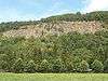
| Old quarry Chambralles (nl) (fr) |
Aywaille | 50.476681°N 5.635885°E |
62009-CLT-0002-01 Info |
 Oude groeve van Chambralles | ||
| Site of the Saints-Anges church and the surrounding area including the old cemetery and the square before the church, the linden trees, the beech and the pump (nl) (fr) |
Aywaille | Dieupart-sous-Aywaille | 50.476052°N 5.688736°E |
62009-CLT-0003-01 Info |
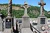 Site van de kerk Saints-Anges en de omgeving waaronder de oude begraafplaats en het plein voor de kerk, de lindebomen, de beuk en de pomp | |
| Chapel of Sainte-Anne Pouhon (nl) (fr) |
Aywaille | Harzé | 50.420308°N 5.665715°E |
62009-CLT-0004-01 Info |
 Kapel Sainte-Anne van Pouhon | |
| Church Saints-Anges (nl) (fr) |
Aywaille | Dieupart-sous-Aywaille | 50.475398°N 5.687891°E |
62009-CLT-0005-01 Info |
 Kerk Saints-Anges | |
| Castle Harzé and the esplanade, the courtyard, outbuildings and the old cemetery in the park around the site of the old church (nl) (fr) |
Aywaille | 50.441325°N 5.666457°E |
62009-CLT-0006-01 Info |
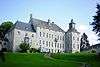 Kasteel van Harzé en het ensemble van het kasteel, de esplanade, de binnenplaats, de bijgebouwen en het park met oude begraafplaats rond de plaats van de oude kerk | ||
| Tower from the 14th century church of Notre-Dame and Saint-Martin (nl) (fr) |
Aywaille | Sougné-Remouchamps | 50.482391°N 5.705801°E |
62009-CLT-0008-01 Info |
||
| Valley of the Ninglinspo (nl) (fr) |
Aywaille | Sougné-Remouchamps | 50.468467°N 5.744252°E |
62009-CLT-0009-01 Info |
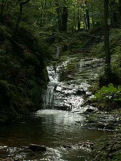 Vallei van Ninglinspo | |
| Fonds de Quarreux (nl) (fr) |
Aywaille | Sougné-Remouchamps | 50.451328°N 5.739948°E |
62009-CLT-0010-01 Info |
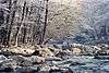 Ensemble van de Fonds de Quarreux | |
| Fonds de Quarreux surroundings (nl) (fr) |
Aywaille | Aywaille | 50.430472°N 5.727693°E |
62009-CLT-0011-01 Info |
Tereinen van de Fonds de Quarreux | |
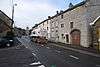
| House (nl) (fr) |
Aywaille | Deigné | 50.507789°N 5.730400°E |
62009-CLT-0013-01 Info |
||
| House (nl) (fr) |
Aywaille | rue Lambier 1, Remouchamps | 50.482450°N 5.703251°E |
62009-CLT-0014-01 Info |
||
| Lane of red beech trees (nl) (fr) |
Aywaille | Dieupart | 50.476281°N 5.689206°E |
62009-CLT-0016-01 Info |
||
| Awan Village (nl) (fr) |
Aywaille | 50.459299°N 5.644749°E |
62009-CLT-0017-01 Info |
 Dorp van Awan | ||
| Chapel of Sainte-Anne du Pouhon and its surroundings (nl) (fr) |
Aywaille | Harzé | 50.419113°N 5.663298°E |
62009-CLT-0018-01 Info |
Ensemble van de kapel Sainte-Anne du Pouhon en diens omgeving | |
| Castle Remouchamps (nl) (fr) |
Aywaille | route de Remouchamps | 50.478064°N 5.689565°E |
62009-CLT-0019-01 Info |
_-_62009-CLT-0019-01.jpg) Kasteel: gevels en daken | |
| Linden trees (nl) (fr) |
Aywaille | Place de Deigne | 50.506655°N 5.729521°E |
62009-CLT-0021-01 Info |
.jpg) Lindebomen op het place de Deigne | |
| House (nl) (fr) |
Aywaille | n°14, Deigné | 50.507957°N 5.730251°E |
62009-CLT-0022-01 Info |
||
| Site of Grotte de Remouchamps (nl) (fr) |
Aywaille | 50.480130°N 5.711766°E |
62009-CLT-0023-01 Info |
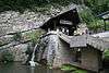 Site van de Grotten van Remouchamps en omgeving | ||
| Grottes de Remouchamps & chantoir de Sécheval (nl) (fr) |
Aywaille | 50.485852°N 5.719374°E |
62009-CLT-0024-01 Info |
|||
| Chantoir de Sécheval (nl) (fr) |
Aywaille | Sougné-Remouchamps | 50.489380°N 5.718511°E |
62009-CLT-0025-01 Info |
.JPG) Chantoir de Sécheval | |
| "Heid des Gattes" (nl) (fr) |
Aywaille | 50.480066°N 5.692060°E |
62009-CLT-0030-01 Info |
 Ensemble van "Heid des Gattes" | ||
| Amblève castle ruins (nl) (fr) |
Aywaille | 50.479930°N 5.645193°E |
62009-CLT-0031-01 Info |
.JPG) Ensemble van de ruïnes van het kasteel van Amblève en zijn directe omgeving | ||
| Valley of the Ninglinspo (nl) (fr) |
Aywaille | Sougné-Remouchamps | 50.468467°N 5.744252°E |
62009-PEX-0001-01 Info |
Vallei van Ninglinspo | |
| Fonds de Quarreux (nl) (fr) |
Aywaille | Sougné-Remouchamps | 50.451328°N 5.739948°E |
62009-PEX-0002-01 Info |
Ensemble van de Fonds de Quarreux | |
| Fonds de Quarreux extension (nl) (fr) |
Aywaille | Aywaille | 50.430472°N 5.727693°E |
62009-PEX-0003-01 Info |
De terreinen die een uitbreiding vormen op de classificatie van de Fonds de Quarreux | |
| Underground part of grottes de Remouchamps (part 1) (nl) (fr) |
Aywaille | 50.480130°N 5.711766°E |
62009-PEX-0004-01 Info |
 Het ondergrondse gedeelte van de site van de grotten van Remouchamps (deel 1) | ||
| Underground part of grottes de Remouchamps (part 2) (nl) (fr) |
Aywaille | 50.485852°N 5.719374°E |
62009-PEX-0005-01 Info |
Het ondergrondse gedeelte van de site van de grotten van Remouchamps (deel 2) | ||
| "Heid des Gattes" (nl) (fr) |
Aywaille | 50.480066°N 5.692060°E |
62009-PEX-0006-01 Info |
Ensemble van "Heid des Gattes" |
See also
- List of protected heritage sites in Liège (province)
| Wikimedia Commons has media related to Cultural heritage monuments in Aywaille. |
References
- Belgian heritage register: Direction générale opérationnelle - Aménagement du territoire, Logement, Patrimoine et Energie (DG4)
- www.dglive.be