List of places on the Victorian Heritage Register in the Rural City of Mildura
This is a list of places on the Victorian Heritage Register in the Rural City of Mildura in Victoria, Australia. The Victorian Heritage Register is maintained by the Heritage Council of Victoria.
The Victorian Heritage Register, as of 2020, lists the following 14 state-registered places within the Rural City of Mildura:[1]
| Place name | Place # | Location | Suburb or Town | Co-ordinates | Built | Stateregistered | Photo |
|---|---|---|---|---|---|---|---|
| Big Lizzie | H1919 | cnr Calder Hwy and Jamieson Ave | Red Cliffs | 34.307960°S 142.186820°E | 1915 | 15 March 2001 | 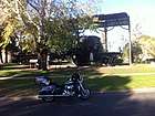 |
| Billabong Pumping Station | H0547 | Cooke St | Nichols Point | 34.229890°S 142.219870°E | 1889 | 26 October 1983 | |
| Horticulture Research Station | H2316 | 571-585 River Ave | Merbein South | 34.212610°S 142.041680°E | 1919 | 13 December 2012 | |
| Irymple railway station | H1568 | Railway Crescent | Irymple | 34.240600°S 142.172250°E | 1903 | 20 August 1982 | |
| Kow Plains Homestead | H0688 | 99 Cowangie South Rd | Cowangie | 35.239970°S 141.391700°E | 1879 | 15 June 1988 | |
| Lock Nine Pumping Station | H0549 | Lock 9 Rd | Cullulleraine | 34.191290°S 141.603630°E | 1926 | 26 October 1983 | |
| Methodist Church | H0588 | 126-132A Deakin Ave | Mildura | 34.188660°S 142.159170°E | 1912 | 3 October 1984 | 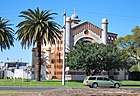 |
| Mildara Blass Distillery | H1099 | 2 Wentworth Rd | Merbein | 34.167030°S 142.079920°E | 1913 | 14 September 1995 | |
| Murrayville Consolidated School | H1185 | 27 Poole St | Murrayville | 35.264740°S 141.180370°E | 1943 | 19 December 1996 | |
| Murrayville railway station | H1580 | McKenzie St | Murrayville | 35.261460°S 141.183220°E | 1912 | 20 August 1982 | |
| Old Mildura Base Hospital | H1934 | 137-157 Thirteenth St | Mildura | 34.190970°S 142.151250°E | 1934 | 10 May 2001 | |
| Old Nichols Point Primary School Shelter Shed | H2363 | 110 Koorlong Ave | Nichols Point | 34.209960°S 142.203040°E | 1911 | 14 July 2016 | |
| Psyche Bend Pumping Station | H0548 | Psyche Bend Rd | Irymple | 34.253480°S 142.230760°E | 1891 | 26 October 1983 | 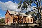 |
| Rio Vista | H0729 | 199-205 Cureton Ave | Mildura | 34.177340°S 142.158630°E | 1889 | 3 May 1989 | 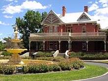 |
References
- "Mildura Rural City". Victorian Heritage Database. Heritage Council of Victoria. Retrieved 17 April 2020.
This article is issued from Wikipedia. The text is licensed under Creative Commons - Attribution - Sharealike. Additional terms may apply for the media files.