List of places on the Victorian Heritage Register in the City of Maribyrnong
This is a list of places on the Victorian Heritage Register in the City of Maribyrnong in Victoria, Australia. The Victorian Heritage Register is maintained by the Heritage Council of Victoria.
The Victorian Heritage Register, as of 2020, lists the following 22 state-registered places within the City of Maribyrnong:[1]
| Place name | Place # | Location | Suburb or Town | Co-ordinates | Built | Stateregistered | Photo |
|---|---|---|---|---|---|---|---|
| Barkly Theatre | H0878 | 277-287 Barkly St | Footscray | 37.799530°S 144.894740°E | 1914 | 28 August 1991 | .jpg) |
| CSR Sugar Refinery Complex | H1311 | 265 Whitehall St | Yarraville | 37.819230°S 144.904490°E | 1872-73 | 8 May 1997 | |
| Ercildoune | H0494 | 66 Napier St | Footscray | 37.804110°S 144.901870°E | 1876 | 26 August 1981 | .jpg) |
| ETA Foods Factory | H1916 | 254 Ballarat Rd | Braybrook | 37.779860°S 144.859130°E | 1961 | 31 May 2001 | |
| Footscray Park | H1220 | 4-68 Ballarat Rd | Footscray | 37.793850°S 144.905630°E | 1911 | 21 November 1996 |  |
| Footscray Primary School | H1713 | 100 Geelong Road | Footscray | 37.798200°S 144.892600°E | 1868 | 20 August 1982 | .jpg) |
| Footscray railway station | H1563 | Irving and Hyde Sts | Footscray | 37.802450°S 144.901290°E | 1900 | 20 August 1982 | 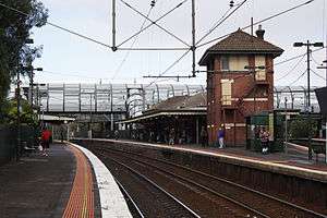 |
| Footscray Town Hall | H1218 | 61 Napier St | Footscray | 37.804500°S 144.900660°E | 1936 | 21 November 1996 | .jpg) |
| Henderson House | H0183 | 43-45 Moreland St | Footscray | 37.803030°S 144.907600°E | 1872-73 | 9 October 1974 | |
| Interlocking Railway Crossing Gates | H1028 | Anderson St | Yarraville | 37.816460°S 144.889680°E | 1890 | 29 September 1994 | 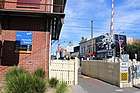 |
| Jack's Magazine | H1154 | off La Scala Ave | Maribyrnong | 37.781640°S 144.895380°E | 1876-78 | 18 April 1996 |  |
| Kariwara District Scout Headquarters | H1343 | 4 Hyde St | Footscray | 37.803490°S 144.901460°E | 1925-29 | 4 September 1997 | .jpg) |
| Kinnears Ropeworks | H2067 | 124-188 Ballarat Rd | Footscray | 37.791720°S 144.892480°E | 1909 | 3 March 2005 | 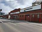 |
| Maribyrnong Migrant Hostel | H2190 | 61-71 Hampstead Rd | Maidstone | 37.775980°S 144.876990°E | 1942 | 12 February 2009 | |
| Maribyrnong Tram Substation | H2321 | 149A and 149B Raleigh Rd | Maribyrnong | 37.770620°S 144.884710°E | 1941-42 | 12 December 2013 | |
| Pipemakers Park Complex | H1503 | 2 Van Ness Ave | Maribyrnong | 37.776250°S 144.894560°E | 1868 | 20 August 1982 | |
| Royal Australian Field Artillery Barracks | H1098 | Wests Rd, Ordnance Reserve and Waterford Ave |
Maribyrnong | 37.773210°S 144.880840°E | 1911 | 5 October 1995 | |
| Saltwater River Crossing Site and Footscray Wharves Precinct | H1397 | west bank of the Maribyrnong River | Footscray | 37.801360°S 144.908410°E | 1800s | 11 December 1997 | |
| Saltwater River Rail Bridge | H1213 | over the Maribyrnong River | Footscray and West Melbourne |
37.798200°S 144.916210°E | 1858-59 | 24 October 1996 | 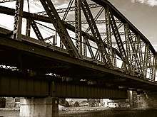 |
| State Savings Bank Building | H0723 | 13 Ballarat St | Yarraville | 37.816350°S 144.891200°E | 1909 | 22 February 1989 | |
| Sun Theatre | H0679 | 6-12 Ballarat St | Footscray | 37.816000°S 144.890700°E | 1938 | 23 December 1987 | 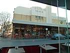 |
| The Pebbles | H1308 | 57A Droop St | Footscray | 37.796360°S 144.896390°E | 1920 | 16 October 1997 | 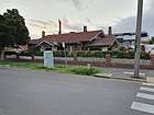 |
References
- "Maribyrnong City". Victorian Heritage Database. Heritage Council of Victoria. Retrieved 6 April 2020.
This article is issued from Wikipedia. The text is licensed under Creative Commons - Attribution - Sharealike. Additional terms may apply for the media files.