List of places on the Victorian Heritage Register in the Borough of Queenscliffe
This is a list of places on the Victorian Heritage Register in the Borough of Queenscliffe in Victoria, Australia. The Victorian Heritage Register is maintained by the Heritage Council of Victoria.
The Victorian Heritage Register, as of 2020, lists the following 16 state-registered places within the Borough of Queenscliffe:[1]
| Place name | Place # | Location | Suburb or Town | Co-ordinates | Built | Stateregistered | Photo |
|---|---|---|---|---|---|---|---|
| Arilpa | H1132 | 77 Glaneuse Rd | Point Lonsdale | 38.281400°S 144.610340°E | 1913 | 23 May 1996 | |
| Ballara | H1126 | 57-73 Glaneuse Rd | Point Lonsdale | 38.282700°S 144.610140°E | 1907-08 | 21 December 1995 | |
| Fisherman's Shed | H2074 | 1 Weeroona Pde and 2 Wharf St |
Queenscliff | 38.264630°S 144.667470°E | unknown | 10 February 2005 | |
| Lathamstowe | H1052 | 44 Gellibrand St | Queenscliff | 38.269070°S 144.661380°E | 1882-83 | 8 September 1994 | |
| Ozone Hotel | H1142 | 42 Gellibrand St | Queenscliff | 38.268720°S 144.661270°E | 1881 | 14 December 1995 | 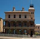 |
| Pilots' Cottages | H1618 | 60-62 Gellibrand St | Queenscliff | 38.270460°S 144.660650°E | 1853-54 | 20 August 1982 | |
| Point Lonsdale Maritime and Defence Precinct | H1517 | 2 Point Lonsdale Rd | Point Lonsdale | 38.290920°S 144.613600°E | 1850s | 20 August 1982 | |
| Queenscliff Hotel | H1141 | 16 Gellibrand St | Queenscliff | 38.266460°S 144.662510°E | 1887 | 14 December 1995 | 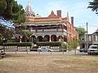 |
| Queenscliff Pier and Lifeboat Complex | H1515 | Symonds St | Queenscliff | 38.267600°S 144.667440°E | 1884-89 | 20 August 1982 | .jpeg) |
| Queenscliff railway station | H1586 | 20 Symonds St | Queenscliff | 38.264320°S 144.662360°E | 1881 | 20 August 1982 | 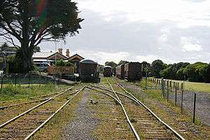 |
| Rosenfeld | H1134 | 26 King St | Queenscliff | 38.269980°S 144.657350°E | 1859 | 14 December 1995 | |
| Roseville Cottage | H1148 | 42 Mercer St | Queenscliff | 38.268440°S 144.656680°E | 1863-64 | 29 February 1996 | |
| Shortlands Bluff | H2367 | 133-135 Hesse St | Queenscliff | 38.273310°S 144.658830°E | 1840s | 21 February 2019 | |
| St George the Martyr Church and Parish Hall | H1125 | 16-26 Hobson St | Queenscliff | 38.266020°S 144.659430°E | 1863-64 | 30 November 1995 | 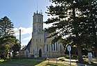 |
| Warringah | H1177 | 80 Mercer St | Queenscliff | 38.271530°S 144.655290°E | c. 1860 | 18 April 1996 | |
| Wreck Bell | H2070 | Princes Park cnr Wharf St and Gellibrand St |
Queenscliff | 38.265240°S 144.664140°E | 1891 | 9 December 2004 | |
References
- "Queenscliffe Borough". Victorian Heritage Database. Heritage Council of Victoria. Retrieved 19 April 2020.
This article is issued from Wikipedia. The text is licensed under Creative Commons - Attribution - Sharealike. Additional terms may apply for the media files.