List of listed buildings in Westray, Orkney
List
| Name | Location | Date Listed | Grid Ref. [note 1] | Geo-coordinates | Notes | LB Number [note 2] | Image |
|---|---|---|---|---|---|---|---|
| Heather View | 59°18′59″N 2°59′47″W | Category C(S) | 19910 |  | |||
| Cleat Farm Including Doocot | 59°18′16″N 2°56′31″W | Category B | 18730 | | |||
| Noup Head Lighthouse Including Perimeter Wall, Gatepiers And Sundial Base | 59°19′52″N 3°04′13″W | Category B | 18736 | 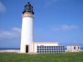 | |||
| Brough Farmhouse | 59°18′35″N 2°58′09″W | Category B | 18804 | | |||
| Pierowall, Westray Baptist Church, including Boundary Wall | 59°19′10″N 2°59′35″W | Category C(S) | 18806 | | |||
| Brough Farm, Steading | 59°18′37″N 2°58′11″W | Category C(S) | 47993 | | |||
| Pierowall Harbour, Gill Pier | 59°19′25″N 2°58′27″W | Category C(S) | 48001 | | |||
| Langskaill Old Manse | 59°16′01″N 2°59′17″W | Category B | 18732 | | |||
| Westray Parish Church (Church Of Scotland) Including Boundary Walls And Ancillary Structure | 59°17′54″N 2°57′20″W | Category C(S) | 46706 | | |||
| Langskaill Farm | 59°16′06″N 2°59′10″W | Category C(S) | 47996 | | |||
| Cleat Including Gatepiers And Wall | 59°18′14″N 2°56′32″W | Category B | 18729 | | |||
| Noltland Castle | 59°19′15″N 3°00′15″W | Category A | 18735 | 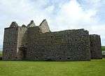 | |||
| Braehead, Blinkbonny House Including Outbuilding | 59°18′30″N 2°58′38″W | Category C(S) | 47991 | | |||
| To North Of Helzie, Windmill Stump | 59°14′58″N 2°51′58″W | Category C(S) | 47995 | | |||
| Sangar | 59°15′32″N 2°51′51″W | Category B | 48010 | | |||
| Pierowall, Lady Kirk, Including Boundary Wall | 59°19′19″N 2°59′12″W | Category B | 18737 | 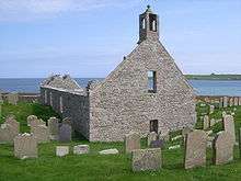 | |||
| Rackwick, Old Berriedale | 59°20′08″N 2°57′51″W | Category C(S) | 48004 | | |||
| Rusk Holm, House | 59°12′22″N 2°51′14″W | Category C(S) | 48009 | | |||
| South Hamar | 59°16′42″N 2°58′04″W | Category B | 48012 | | |||
| Swartaback | 59°16′08″N 2°53′12″W | Category C(S) | 48013 | | |||
| Brough House, Including Boundary Wall | 59°18′42″N 2°58′13″W | Category B | 18733 | | |||
| Pierowall, Trenabie Bere Mill | 59°18′51″N 2°59′18″W | Category B | 18734 | | |||
| Braehead, Westray United Free Church Of Scotland Including Garden Wall | 59°18′31″N 2°58′31″W | Category C(S) | 47992 | | |||
| Cornhouse | 59°19′00″N 2°58′10″W | Category C(S) | 47994 | | |||
| Langskaill Old Manse, Farm | 59°16′03″N 2°59′20″W | Category C(S) | 47997 | | |||
| Lochside, Pigsty And Shed | 59°17′39″N 2°55′29″W | Category C(S) | 47998 | | |||
| Pierowall, Gill Point, Storehouse | 59°19′27″N 2°58′23″W | Category B | 48000 | | |||
| Pierowall, Trenabie Mill Including Lade | 59°18′51″N 2°59′18″W | Category B | 48002 | | |||
| Pierowall, Cottage St Clair | 59°19′09″N 2°59′24″W | Category C(S) | 47999 | | |||
| Pierowall, War Memorial | 59°19′23″N 2°59′12″W | Category C(S) | 48003 | | |||
| Skelwick, Hillhouse | 59°17′01″N 2°54′00″W | Category C(S) | 48011 | |
Key
The scheme for classifying buildings in Scotland is:
- Category A: "buildings of national or international importance, either architectural or historic; or fine, little-altered examples of some particular period, style or building type."[1]
- Category B: "buildings of regional or more than local importance; or major examples of some particular period, style or building type, which may have been altered."[1]
- Category C: "buildings of local importance; lesser examples of any period, style, or building type, as originally constructed or moderately altered; and simple traditional buildings which group well with other listed buildings."[1]
In March 2016 there were 47,288 listed buildings in Scotland. Of these, 8% were Category A, and 50% were Category B, with the remaining 42% being Category C.[2]
gollark: You connect it with a *good* thing and it somehow seems better.
gollark: You connect a thing with a bad thing somehow, and people think it's bad.
gollark: It processes horribly fuzzily.
gollark: I was mostly talking about political campaigning, however. We would of course have to disguise their faces and voices.
gollark: Just force them to be written more along the lines of "please help these people afford food", instead of playing on human things with... what is it, sad music, pictures of specific people, sort of thing.
See also
Notes
- Sometimes known as OSGB36, the grid reference (where provided) is based on the British national grid reference system used by the Ordnance Survey.
• "Guide to National Grid". Ordnance Survey. Retrieved 2007-12-12.
• "Get-a-map". Ordnance Survey. Retrieved 2007-12-17. - Historic Environment Scotland assign a unique alphanumeric identifier to each designated site in Scotland, for listed buildings this always begins with "LB", for example "LB12345".
References
- All entries, addresses and coordinates are based on data from Historic Scotland. This data falls under the Open Government Licence
- "What is Listing?". Historic Environment Scotland. Retrieved 29 May 2018.
- Scotland's Historic Environment Audit 2016 (PDF). Historic Environment Scotland and the Built Environment Forum Scotland. pp. 15–16. Retrieved 29 May 2018.
This article is issued from Wikipedia. The text is licensed under Creative Commons - Attribution - Sharealike. Additional terms may apply for the media files.