List of listed buildings in West Kilbride, North Ayrshire
List
| Name | Location | Date Listed | Grid Ref. [note 1] | Geo-coordinates | Notes | LB Number [note 2] | Image |
|---|---|---|---|---|---|---|---|
| Hunterston House | 55°43′31″N 4°52′49″W | Category B | 14286 | 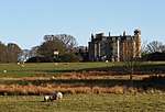 | |||
| St Andrews (Formerly St Bride's) Church Of Scotland | 55°41′46″N 4°51′18″W | Category B | 14307 | 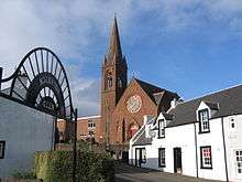 | |||
| Ruin Of Old Abbey Southannan, Fairlie | 55°44′41″N 4°51′16″W | Category B | 14311 |  | |||
| Hunterston Gate (North Pillars) | 55°43′44″N 4°51′57″W | Category B | 14314 | | |||
| Hunterston Gate (South Pillars) | 55°42′41″N 4°52′01″W | Category B | 14315 | | |||
| 73 Main Street And 1 Hunterston Road | 55°41′44″N 4°51′23″W | Category C(S) | 50774 | | |||
| Carlung House | 55°42′05″N 4°52′22″W | Category B | 19686 | | |||
| Law Castle | 55°41′46″N 4°50′53″W | Category A | 14279 | 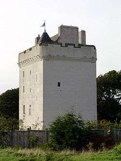 | |||
| Chapelton Farm | 55°40′41″N 4°51′16″W | Category C(S) | 14284 | | |||
| Sea Mill | 55°41′03″N 4°51′41″W | Category B | 14285 | | |||
| Walled Garden, Hunterston | 55°43′22″N 4°52′48″W | Category C(S) | 14288 | | |||
| Sundial, Kirktonhall | 55°41′41″N 4°51′26″W | Category A | 14309 | | |||
| Monument In Cemetery To Dr. Robert Simpson | 55°41′56″N 4°51′19″W | Category C(S) | 14310 | 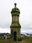 | |||
| Harbours, Portencross | 55°41′58″N 4°54′17″W | Category B | 13899 | | |||
| Seamill Centre, Formerly Seamill House, With Lodge, Boundary Walls And Gatepiers | 55°41′07″N 4°51′28″W | Category A | 43209 | | |||
| Lawoodhead | 55°42′09″N 4°50′42″W | Category B | 14283 | | |||
| Kirktonhall (Offices Of Ayr County Council) | 55°41′42″N 4°51′27″W | Category B | 14308 | 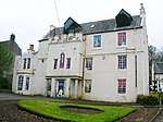 | |||
| West Kilbride Station | 55°41′47″N 4°51′06″W | Category B | 14312 | 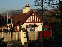 | |||
| Hunterston Castle | 55°43′22″N 4°52′44″W | Category A | 14313 | 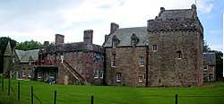 | |||
| Portincross Castle | 55°41′58″N 4°54′18″W | Category A | 14280 |  | |||
| Well In Front Of Mansion | 55°43′32″N 4°52′50″W | Category C(S) | 14287 | | |||
| West Kilbride Barony Parish Church And Graveyard | 55°41′43″N 4°51′20″W | Category C(S) | 14306 | 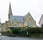 | |||
| Crosbie Towers | 55°42′40″N 4°50′16″W | Category B | 14282 | 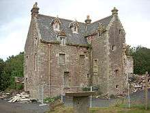 | |||
| West Cottage And Castle Cottage, Portencross | 55°41′56″N 4°54′16″W | Category C(S) | 14281 | | |||
| Ritchie Street, Overton Church (Church Of Scotland), Including Boundary Wall, Gatepiers And Gates | 55°41′36″N 4°51′38″W | Category B | 51402 | 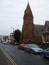 |
Key
The scheme for classifying buildings in Scotland is:
- Category A: "buildings of national or international importance, either architectural or historic; or fine, little-altered examples of some particular period, style or building type."[1]
- Category B: "buildings of regional or more than local importance; or major examples of some particular period, style or building type, which may have been altered."[1]
- Category C: "buildings of local importance; lesser examples of any period, style, or building type, as originally constructed or moderately altered; and simple traditional buildings which group well with other listed buildings."[1]
In March 2016 there were 47,288 listed buildings in Scotland. Of these, 8% were Category A, and 50% were Category B, with the remaining 42% being Category C.[2]
gollark: PotatOS actually has its own very hacky `require` implementation because of some problem or other I forgot.
gollark: Indeed it does.
gollark: Weirdly, `"0"/"0"` seemingly results in them being converted to numbers instead of going through potatOS's string divison handling.
gollark: Apparently not, since `debug.setmetatable` won't let me override division.
gollark: I should see if I can make it produce a more fun result in potatOS.
Notes
- Sometimes known as OSGB36, the grid reference (where provided) is based on the British national grid reference system used by the Ordnance Survey.
• "Guide to National Grid". Ordnance Survey. Retrieved 2007-12-12.
• "Get-a-map". Ordnance Survey. Retrieved 2007-12-17. - Historic Environment Scotland assign a unique alphanumeric identifier to each designated site in Scotland, for listed buildings this always begins with "LB", for example "LB12345".
References
- All entries, addresses and coordinates are based on data from Historic Scotland. This data falls under the Open Government Licence
- "What is Listing?". Historic Environment Scotland. Retrieved 29 May 2018.
- Scotland's Historic Environment Audit 2016 (PDF). Historic Environment Scotland and the Built Environment Forum Scotland. pp. 15–16. Retrieved 29 May 2018.
This article is issued from Wikipedia. The text is licensed under Creative Commons - Attribution - Sharealike. Additional terms may apply for the media files.