List of listed buildings in Wemyss, Fife
List
| Name | Location | Date Listed | Grid Ref. [note 1] | Geo-coordinates | Notes | LB Number [note 2] | Image |
|---|---|---|---|---|---|---|---|
| West Wemyss, 22-36 (Even Nos) Main Street | 56°08′23″N 3°05′10″W | Category B | 16657 |  | |||
| West Wemyss, 2-20 (Even Nos) Main Street | 56°08′23″N 3°05′14″W | Category B | 16695 | | |||
| Coaltown Of Wemyss, Main Street, Earl David Hotel | 56°09′07″N 3°05′05″W | Category C(S) | 46034 | | |||
| East Wemyss, Main Street And Back Dykes, War Memorial | 56°09′32″N 3°03′50″W | Category C(S) | 46042 | | |||
| West Wemyss, Belvedere Hotel Including 1-2 And 5-11 (Inclusive Nos) Coxstool, Ancillary Buildings And Boundary Walls | 56°08′24″N 3°05′17″W | Category B | 46055 | | |||
| West Wemyss, 1 Burn's Wynd And Main Street | 56°08′25″N 3°05′05″W | Category C(S) | 46057 | | |||
| West Wemyss, Manse Including Boundary Walls | 56°08′25″N 3°05′16″W | Category C(S) | 46064 | | |||
| West Wemyss, 57 Main Street | 56°08′25″N 3°05′08″W | Category B | 19126 | | |||
| West Wemyss, 38 And 40 Main Street | 56°08′24″N 3°05′07″W | Category B | 16658 | | |||
| West Wemyss, 42-52 (Even Nos) Main Street | 56°08′24″N 3°05′07″W | Category C(S) | 16659 | | |||
| West Wemyss, Chapel Garden Including House (Ruin), Sea Wall And Towers, Wemyss Burial Enclosure And House | 56°08′23″N 3°05′49″W | Category B | 16671 | | |||
| West Wemyss, Harbour | 56°08′21″N 3°05′25″W | Category C(S) | 16675 | | |||
| West Wemyss, 3 And 4 Coxstool With Boundary Wall | 56°08′24″N 3°05′17″W | Category B | 16692 | | |||
| West Wemyss, Main Street, Tolbooth | 56°08′23″N 3°05′10″W | Category B | 16694 | | |||
| Eastwemyss, Macduff's Castle | 56°09′46″N 3°03′28″W | Category B | 16707 | 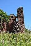 | |||
| East Wemyss, Main Road, The Carshed Shop | 56°09′28″N 3°04′11″W | Category C(S) | 46039 | | |||
| East Wemyss, 15 Main Street With Boundary Walls | 56°09′33″N 3°03′51″W | Category C(S) | 46040 | | |||
| Standing Stane Road, Cowdenlaws | 56°08′53″N 3°07′06″W | Category C(S) | 46047 | | |||
| Standing Stane Road, Wellsgreen With Well, Boundary Walls, Gatepiers And Gates | 56°10′25″N 3°03′59″W | Category C(S) | 46050 | | |||
| West Wemyss, Main Street, Wemyss Arms | 56°08′25″N 3°05′06″W | Category C(S) | 46063 | | |||
| West Wemyss Toll | 56°08′50″N 3°05′53″W | Category C(S) | 46067 | | |||
| Wemyss Castle Policies, West Entrance, Dysart Lodge, Gatepiers, Gates And Boundary Walls | 56°08′16″N 3°06′47″W | Category C(S) | 19127 | | |||
| Wemyss Castle Policies, Dovecot | 56°08′36″N 3°04′56″W | Category B | 16670 | | |||
| Coaltown Of Wemyss, Main Street, Miners' Welfare Institute And War Memorial | 56°09′04″N 3°05′22″W | Category C(S) | 46035 | | |||
| East Wemyss 29 And 31 Main Road | 56°09′30″N 3°04′11″W | Category C(S) | 46037 | | |||
| Wemyss Castle Policies, Nos 1, 2 And 3 Cottages Including Garden Wall | 56°08′51″N 3°04′59″W | Category C(S) | 46051 | | |||
| West Wemyss, 67 And 69 Main Street | 56°08′26″N 3°05′06″W | Category C(S) | 46062 | | |||
| West Wemyss, St Adrian's Church (Church Of Scotland) With Boundary Walls, Graveyard And Monuments | 56°08′31″N 3°05′00″W | Category C(S) | 46066 | 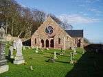 | |||
| Wemyss Castle Policies, The Pink House | 56°08′45″N 3°05′02″W | Category B | 49183 | | |||
| West Wemyss, 3 Burn's Wynd | 56°08′25″N 3°05′06″W | Category C(S) | 16696 | | |||
| East Wemyss, 11 And 13 Main Street, Former Manse With Boundary Walls And Gatepier | 56°09′34″N 3°03′52″W | Category B | 16705 | | |||
| East Wemyss, School Wynd, Primary School With Boundary Walls And Gatepiers | 56°09′37″N 3°03′53″W | Category C(S) | 46043 | | |||
| East Wemyss, 22 West Brae | 56°09′33″N 3°03′57″W | Category C(S) | 46044 | | |||
| East Wemyss, 24 West Brae With Boundary Walls And Gatepiers | 56°09′32″N 3°03′57″W | Category C(S) | 46045 | | |||
| Wemyss Castle Policies, The Courtyard (Home Farm) Including Stables And Gatepiers | 56°08′46″N 3°04′59″W | Category B | 46052 | | |||
| West Wemyss, 59 And 61 Main Street | 56°08′25″N 3°05′07″W | Category B | 46060 | | |||
| West Wemyss, Shorehead Including Boundary Walls | 56°08′24″N 3°05′24″W | Category B | 16676 | | |||
| West Wemyss, 12 And 13 Coxstool With Boundary Walls | 56°08′23″N 3°05′19″W | Category B | 16677 | | |||
| East Wemyss, Main Street, St Mary's By-The-Sea (Former Parish Church) Including Boundary Walls, Gatepiers And Gates | 56°09′32″N 3°03′50″W | Category B | 16704 | | |||
| West Wemyss, 1B Narrow Wynd, Building To Rear Of Wemyss Arms | 56°08′26″N 3°05′07″W | Category C(S) | 46065 | | |||
| East Wemyss, Dovecot Cave | 56°09′53″N 3°03′07″W | Category B | 16708 | 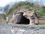 | |||
| East Wemyss, Main Road, Bowling Club With Terrace And Walls With Gatepiers | 56°09′31″N 3°04′14″W | Category C(S) | 46038 | | |||
| East Wemyss, Main Street, St Mary's By-The-Sea Graveyard, Walls And Gravestones | 56°09′32″N 3°03′49″W | Category B | 46041 | | |||
| Newton Farmhouse Including Boundary Wall | 56°09′37″N 3°04′46″W | Category B | 46046 | | |||
| Wemyss Castle Policies, Walled Garden With Orangery (Ruin) | 56°08′49″N 3°04′49″W | Category C(S) | 46054 | | |||
| West Wemyss, 4, 5 And 6 Burn's Wynd | 56°08′24″N 3°05′06″W | Category C(S) | 46058 | | |||
| West Wemyss, 65 Main Street | 56°08′26″N 3°05′06″W | Category C(S) | 46061 | | |||
| West Wemyss, 1 - 9 (Odd Nos) Main Street With Boundary Walls | 56°08′24″N 3°05′12″W | Category C(S) | 16697 | | |||
| Wemyss Castle | 56°08′40″N 3°04′52″W | Category A | 16709 | 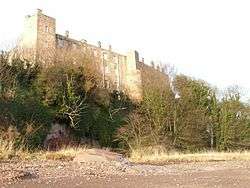 | |||
| Bowhouse Including Boundary Walls And Gatepiers | 56°08′37″N 3°06′15″W | Category C(S) | 46033 | | |||
| East Wemyss, 25 And 27 Main Road | 56°09′29″N 3°04′12″W | Category C(S) | 46036 | | |||
| Standing Stane Road, Moss Cottage | 56°09′26″N 3°06′30″W | Category C(S) | 46048 | | |||
| Wemyss Castle Policies, The Red House | 56°08′43″N 3°04′51″W | Category B | 46053 | | |||
| West Wemyss, 5 Broad Wynd With Boundary Walls | 56°08′25″N 3°05′11″W | Category C(S) | 46056 | | |||
| Wemyss Castle Policies, East Lodge With Boundary Walls, Gatepiers And Gates | 56°09′18″N 3°04′35″W | Category B | 19128 | | |||
| Boreland, Branxton Farmhouse With Ancillary Structure | 56°08′23″N 3°07′07″W | Category C(S) | 46031 | | |||
| Boreland, Standing Stane Road, West Gate | 56°08′28″N 3°07′23″W | Category C(S) | 46032 | | |||
| Standing Stane Road, Phantassie | 56°09′15″N 3°06′50″W | Category C(S) | 46049 | | |||
| West Wemyss, Croftamorie, War Memorial | 56°08′29″N 3°05′01″W | Category C(S) | 46059 | |
Key
The scheme for classifying buildings in Scotland is:
- Category A: "buildings of national or international importance, either architectural or historic; or fine, little-altered examples of some particular period, style or building type."[1]
- Category B: "buildings of regional or more than local importance; or major examples of some particular period, style or building type, which may have been altered."[1]
- Category C: "buildings of local importance; lesser examples of any period, style, or building type, as originally constructed or moderately altered; and simple traditional buildings which group well with other listed buildings."[1]
In March 2016 there were 47,288 listed buildings in Scotland. Of these, 8% were Category A, and 50% were Category B, with the remaining 42% being Category C.[2]
gollark: It *might* be.
gollark: Row ID? I forget.
gollark: The number the uninstaller prints?
gollark: The incident report system does actually work, by the way. All incidents are logged in SPUDNET. The only ones I know of are the test ones I triggered to test the system and various incident triggers. Incidents are reported when:- one known sandbox escape is detected- banned programs (Webicity) are executed- potatOS is uninstalled- invalid disk signing key
gollark: You can't make a program to fully autonomously uninstall potatOS from within it - ignoring sandbox escapes - because while sandboxed processes can use queueEvent to fake keypresses they cannot read the output of the uninstaller. The best they can do is, I don't know, guess what the random seed was when it was generating two primes, figure out what the primes were, and queue the key/char events accordingly.
See also
Notes
- Sometimes known as OSGB36, the grid reference (where provided) is based on the British national grid reference system used by the Ordnance Survey.
• "Guide to National Grid". Ordnance Survey. Retrieved 2007-12-12.
• "Get-a-map". Ordnance Survey. Retrieved 2007-12-17. - Historic Environment Scotland assign a unique alphanumeric identifier to each designated site in Scotland, for listed buildings this always begins with "LB", for example "LB12345".
References
- All entries, addresses and coordinates are based on data from Historic Scotland. This data falls under the Open Government Licence
- "What is Listing?". Historic Environment Scotland. Retrieved 29 May 2018.
- Scotland's Historic Environment Audit 2016 (PDF). Historic Environment Scotland and the Built Environment Forum Scotland. pp. 15–16. Retrieved 29 May 2018.
This article is issued from Wikipedia. The text is licensed under Creative Commons - Attribution - Sharealike. Additional terms may apply for the media files.