List of listed buildings in Walls And Flotta, Orkney
List
| Name | Location | Date Listed | Grid Ref. [note 1] | Geo-coordinates | Notes | LB Number [note 2] | Image |
|---|---|---|---|---|---|---|---|
| Walls, (Hoy), Melsetter House Including Garden Walls And Former Kennels | 58°47′08″N 3°15′48″W | Category A | 18712 |  | |||
| Flotta (Hoy), Whome Kiln And Barn | 58°49′39″N 3°06′30″W | Category C(S) | 48333 | | |||
| Walls (Hoy), Longhope Lifeboat Station | 58°46′47″N 3°13′41″W | Category B | 48347 | | |||
| Walls (Hoy), Melsetter, Gardener's Cottage, Including Stone Setts And Garden Wall To North | 58°47′09″N 3°15′52″W | Category B | 48366 | | |||
| Walls (Hoy), North Ness, Milestone | 58°48′23″N 3°12′13″W | Category C(S) | 48375 | | |||
| South Walls (Hoy), Longhope, Church Of St Columba, (Longhope Parish Church, Church Of Scotland) | 58°47′58″N 3°11′31″W | Category C(S) | 18809 | | |||
| Flotta (Hoy), Bow Old Farmhouse, Byre And Barn | 58°49′24″N 3°05′51″W | Category C(S) | 18814 | | |||
| South Walls (Hoy), Kirbuster, Letter Box | 58°48′04″N 3°09′36″W | Category C(S) | 48336 | | |||
| South Walls (Hoy), Longhope, Milestone To North East Of Morven | 58°48′04″N 3°11′00″W | Category C(S) | 48340 | | |||
| South Walls, (Hoy), South Ness, War Memorial | 58°47′59″N 3°12′24″W | Category C(S) | 48345 | | |||
| Walls (Hoy), The Garrison (Former Garrison Theatre) | 58°48′45″N 3°12′02″W | Category C(S) | 48346 | | |||
| Walls (Hoy), Milestone To West Of Lyrawa Bay | 58°52′19″N 3°14′12″W | Category C(S) | 48358 | | |||
| Walls (Hoy), Melsetter House, Lodge, Gates, Gatepiers And Field Boundary Walls And Gatepiers | 58°47′10″N 3°15′50″W | Category C(S) | 48363 | | |||
| Walls (Hoy), Melsetter, The Laundry House, Including Walled Yard To North And Wall And Gatepiers To South East | 58°47′08″N 3°15′53″W | Category B | 48368 | | |||
| Walls (Hoy), Milestone To East Of Pegal Hill | 58°51′47″N 3°13′20″W | Category C(S) | 48377 | | |||
| South Walls (Hoy), Cantick Head Lighthouse Including Keepers' Cottages, Sheds, Perimeter Wall And Sundial | 58°47′14″N 3°07′54″W | Category B | 18710 | | |||
| South Walls (Hoy), Crowtaing, Pigsty | 58°47′51″N 3°08′25″W | Category C(S) | 48334 | | |||
| South Walls (Hoy), Glebelands (Former South Walls Manse), Including Walled Garden And Boundary Wall | 58°47′41″N 3°12′03″W | Category C(S) | 48337 | | |||
| South Walls (Hoy), Milestone To South Of Kirbuster House | 58°48′03″N 3°09′32″W | Category C(S) | 48339 | | |||
| South Walls (Hoy), Quoy | 58°47′36″N 3°10′19″W | Category C(S) | 48343 | | |||
| Walls (Hoy), Lyness Pier | 58°50′01″N 3°11′27″W | Category C(S) | 48349 | | |||
| Walls (Hoy), Lyness, Milesone To West Of Haybrake | 58°49′57″N 3°12′25″W | Category C(S) | 48355 | | |||
| Walls (Hoy), Melsetter, The Estate Office, Including Boundary Wall And Adjacent Outhouse And Stone Flagged Yard And Gatepiers To West | 58°47′07″N 3°15′56″W | Category B | 48365 | | |||
| Walls (Hoy), Melsetter, The Hall, Including Gatepiers To West | 58°47′07″N 3°15′55″W | Category B | 48367 | | |||
| Walls (Hoy), Millhouse | 58°50′30″N 3°12′41″W | Category C(S) | 48371 | | |||
| Walls (Hoy), Wee Fea Naval Communications And Operational Centre | 58°49′54″N 3°13′29″W | Category B | 48378 | | |||
| Hoy, Lyness, Scapa Flow Visitor Centre, Former Steam Pumping Station And Oil Storage Tank | 58°50′01″N 3°11′48″W | Category A | 50533 | 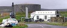 | |||
| Walls (Hoy), St John's Church (Church Of Scotland), Including Boundary Wall | 58°48′21″N 3°13′02″W | Category C(S) | 47969 | | |||
| Walls (Hoy), Lyness Naval Cemetery Including Pavilions, War Memorial And Boundary Walls | 58°50′00″N 3°12′37″W | Category C(S) | 48348 | | |||
| Walls (Hoy), Lyness, Haybrake, Granary | 58°49′55″N 3°12′21″W | Category B | 48354 | | |||
| Melsetter Farm, Steading | 58°47′03″N 3°16′05″W | Category C(S) | 48361 | | |||
| Walls (Hoy), Melsetter House, Kitchen Garden Including Tea-House And Doocot, Rookery Walls And Gatepiers | 58°47′05″N 3°15′50″W | Category A | 48362 | | |||
| Walls (Hoy), Melsetter, Walled Garden (Formerly Rose Garden) To Nw Of Melsetter House, Including Cartshed To West | 58°47′09″N 3°15′52″W | Category B | 48370 | | |||
| Walls (Hoy), Bridge To South East Of Pegal Hill | 58°51′34″N 3°13′36″W | Category B | 48376 | | |||
| South Walls (Hoy), Snelsetter | 58°46′55″N 3°10′31″W | Category B | 44590 | | |||
| South Walls (Hoy), South Ness, Ness House | 58°48′00″N 3°12′23″W | Category B | 19662 | | |||
| Walls (Hoy), 1 North Ness (Formerly The Ship Inn) | 58°48′19″N 3°12′13″W | Category C(S) | 18811 | | |||
| Walls (Hoy), Lyness, Former Metal Industry Shed | 58°49′52″N 3°11′59″W | Category B | 48356 | | |||
| Walls (Hoy), Lyness, Romney Hut | 58°50′06″N 3°11′49″W | Category C(S) | 48357 | | |||
| Walls (Hoy) Melsetter Farmhouse, Including Boundary Wall | 58°47′04″N 3°16′02″W | Category C(S) | 48360 | | |||
| Walls (Hoy), Melsetter Hill Burial Enclosure | 58°47′16″N 3°16′17″W | Category C(S) | 48364 | | |||
| Walls (Hoy), Melsetter, Spinning Cottage | 58°47′08″N 3°15′51″W | Category B | 48369 | | |||
| Walls (Hoy), Rysa Lodge, Including Garden Wall To South And East And Outbuildings To South West | 58°50′52″N 3°12′15″W | Category A | 18714 | | |||
| Flotta (Hoy), Flotta Church (Church Of Scotland), Including War Memorial To South And Boundary Wall | 58°49′14″N 3°05′55″W | Category C(S) | 18813 | 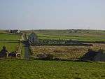 | |||
| South Walls (Hoy), Longhope, The Old Custom House (Including Westburn), Including Boundary Wall | 58°47′55″N 3°11′56″W | Category B | 18709 | | |||
| South Walls (Hoy), Milestone To North Of Gallow Tuag | 58°47′20″N 3°12′12″W | Category C(S) | 48335 | | |||
| South Walls (Hoy), Lythes, Milestone | 58°47′45″N 3°12′50″W | Category C(S) | 48342 | | |||
| South Walls (Hoy), Snelsetter Gatepier | 58°47′11″N 3°09′01″W | Category C(S) | 48344 | | |||
| Walls (Hoy), Muckle Rysa Including Garden Wall | 58°51′11″N 3°12′09″W | Category B | 48373 | | |||
| South Walls (Hoy), Osmondwall, Moodie Mausoleum And Graveyard | 58°47′17″N 3°09′13″W | Category B | 19905 | | |||
| South Walls (Hoy), Hillside | 58°48′07″N 3°08′52″W | Category C(S) | 48338 | | |||
| South Walls (Hoy), Longhope, Royal Hotel, Including Boundary Wall | 58°47′58″N 3°12′28″W | Category C(S) | 48341 | | |||
| Walls (Hoy), Milestone To North Of Millhouse | 58°50′36″N 3°12′41″W | Category C(S) | 48372 | | |||
| Walls (Hoy), Munitions Depot Sw Of Ore Farm | 58°49′16″N 3°12′31″W | Category B | 48374 | | |||
| Walls (Hoy), Lyness, Decontamination Shed | 58°50′03″N 3°12′30″W | Category C(S) | 48353 | | |||
| Walls (Hoy), Melsetter House, Chapel | 58°47′08″N 3°15′50″W | Category A | 48359 | |
Key
The scheme for classifying buildings in Scotland is:
- Category A: "buildings of national or international importance, either architectural or historic; or fine, little-altered examples of some particular period, style or building type."[1]
- Category B: "buildings of regional or more than local importance; or major examples of some particular period, style or building type, which may have been altered."[1]
- Category C: "buildings of local importance; lesser examples of any period, style, or building type, as originally constructed or moderately altered; and simple traditional buildings which group well with other listed buildings."[1]
In March 2016 there were 47,288 listed buildings in Scotland. Of these, 8% were Category A, and 50% were Category B, with the remaining 42% being Category C.[2]
gollark: ++apioform
gollark: ++apioform
gollark: ++deploy attack bees more
gollark: ++deploy attack bees more again
gollark: ++magic py ```pythonimport randombot.remove_command("deploy")@bot.command(rest_is_raw=True)async def deploy(ctx, *, target): if random.randint(0, 7) == 3: await ctx.send("No. Protocol φ-73 initialized.") else: await ctx.send("Deployed " + target.strip())```
See also
Notes
- Sometimes known as OSGB36, the grid reference (where provided) is based on the British national grid reference system used by the Ordnance Survey.
• "Guide to National Grid". Ordnance Survey. Retrieved 2007-12-12.
• "Get-a-map". Ordnance Survey. Retrieved 2007-12-17. - Historic Environment Scotland assign a unique alphanumeric identifier to each designated site in Scotland, for listed buildings this always begins with "LB", for example "LB12345".
References
- All entries, addresses and coordinates are based on data from Historic Scotland. This data falls under the Open Government Licence
- "What is Listing?". Historic Environment Scotland. Retrieved 29 May 2018.
- Scotland's Historic Environment Audit 2016 (PDF). Historic Environment Scotland and the Built Environment Forum Scotland. pp. 15–16. Retrieved 29 May 2018.
This article is issued from Wikipedia. The text is licensed under Creative Commons - Attribution - Sharealike. Additional terms may apply for the media files.