List of listed buildings in Temple, Midlothian
List
| Name | Location | Date Listed | Grid Ref. [note 1] | Geo-coordinates | Notes | LB Number [note 2] | Image |
|---|---|---|---|---|---|---|---|
| Rosebery House Policies, Episcopal Chapel | 55°48′20″N 3°06′32″W | Category B | 14627 |  | |||
| Rosebery House Policies, Lodge | 55°48′21″N 3°06′45″W | Category B | 14628 | | |||
| Temple Village, Old Temple Kirk (Church Of The Knights Templars Of Balantrodoch) Including Boundary Wall And Gatepiers | 55°49′01″N 3°05′40″W | Category B | 14621 | | |||
| Mauldslie Farmhouse And Steading | 55°45′56″N 3°06′15″W | Category B | 45814 | | |||
| 1 And 2 Mauldslie Farm Cottages | 55°45′58″N 3°06′04″W | Category C(S) | 45815 | | |||
| Yorkston Farmhouse, Including Ancillary Structure, Gatepiers And Boundary Walls | 55°47′54″N 3°05′40″W | Category C(S) | 45832 | | |||
| Rosebery House Policies, Main Entrance Gatepiers | 55°48′19″N 3°06′47″W | Category B | 14629 | 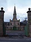 | |||
| Rosebery House Policies, Home Farm | 55°48′19″N 3°06′51″W | Category A | 14630 | 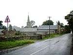 | |||
| Arniston Policies, Ice House | 55°49′10″N 3°04′45″W | Category C(S) | 45806 | | |||
| Braidwood Bridge Over River South Esk, B6372 | 55°49′08″N 3°05′22″W | Category B | 45807 | | |||
| Temple Farm Cottages | 55°48′38″N 3°05′03″W | Category C(S) | 45820 | | |||
| Toxside Farmhouse Including Ancillary Structures, Gates, Gatepiers And Boundary Walls | 55°46′27″N 3°08′56″W | Category B | 45827 | | |||
| Temple Village, The Mill House | 55°49′04″N 3°05′42″W | Category B | 18192 | | |||
| Temple Village, 5 Main Street | 55°49′00″N 3°05′31″W | Category C(S) | 14649 | | |||
| Temple Village, 21 Main Street | 55°48′56″N 3°05′29″W | Category C(S) | 14650 | | |||
| Temple Village 25-27 (Odd Nos) Main Street | 55°48′56″N 3°05′29″W | Category B | 14651 | | |||
| Temple Village, Temple Kirk Session House | 55°49′02″N 3°05′39″W | Category B | 14620 | | |||
| Arniston Policies, Walled Garden, Including Gateways And Loggia | 55°49′14″N 3°04′42″W | Category A | 14625 | | |||
| Esperston Farmhouse, Including Gatepiers | 55°48′05″N 3°03′29″W | Category B | 6644 | | |||
| Upperside Limekiln, South | 55°46′59″N 3°07′48″W | Category C(S) | 45831 | | |||
| Temple Village, Temple Kirk | 55°49′03″N 3°05′40″W | Category B | 14619 | 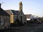 | |||
| Broadhead Cottage | 55°48′07″N 3°05′17″W | Category B | 45809 | | |||
| Fountainside Including Steading And Cart Shed | 55°47′49″N 3°07′24″W | Category C(S) | 45810 | | |||
| Huntly Cot, Glede Knowe Sheep House | 55°45′15″N 3°06′46″W | Category C(S) | 45813 | | |||
| Outerston Farm, Cartshed And Granary | 55°48′07″N 3°04′12″W | Category B | 45817 | | |||
| Arniston Policies, Arniston Gardens House Including Gatepiers | 55°49′12″N 3°04′37″W | Category B | 45804 | | |||
| Arniston Policies, Horace's Bridge Over River South Esk | 55°49′09″N 3°05′17″W | Category B | 45805 | | |||
| Gladhouse Reservoir Including Dam, Weirs, Revetments, Gangway, Measuring House, Tweedaleburn Aqueduct And Bridges Over Tributaries | 55°46′13″N 3°07′00″W | Category B | 45811 | | |||
| Hirendean Hill, Sheep Stell | 55°44′58″N 3°07′14″W | Category C(S) | 45812 | | |||
| Temple Village, 23 Main Street | 55°48′56″N 3°05′29″W | Category C(S) | 45822 | | |||
| Temple Village, 31 Main Street | 55°48′55″N 3°05′29″W | Category C(S) | 45823 | | |||
| Temple Village, 32 Main Street | 55°48′50″N 3°05′24″W | Category C(S) | 45824 | | |||
| Temple Village, Tradoch Hall (Former United Free Church) | 55°48′51″N 3°05′25″W | Category C(S) | 45826 | | |||
| Toxside School, Including Boundary Walls | 55°46′20″N 3°08′08″W | Category C(S) | 45829 | | |||
| Temple Village, Main Street, K6 Telephone Kiosk | 55°48′56″N 3°05′30″W | Category B | 14632 | | |||
| Temple Village, Temple House Gateway | 55°48′59″N 3°05′27″W | Category C(S) | 14648 | | |||
| Braidwood Farm Including Gates, Gatepiers And Boundary Walls | 55°48′59″N 3°06′00″W | Category B | 45808 | | |||
| Millbank Cottage, Including Outbuilding And Walls | 55°48′06″N 3°06′15″W | Category C(S) | 45816 | | |||
| Gladhouse, Gladhouse Villa | 55°46′39″N 3°07′03″W | Category B | 14633 | | |||
| Outerston Farm, Cottage | 55°48′06″N 3°04′12″W | Category C(S) | 45818 | | |||
| Temple Village, 14 Main Street, Temple Cottage, Including Ancillary Structure, Garden Walls And Steps | 55°48′55″N 3°05′30″W | Category B | 45821 | | |||
| Temple Village, 34 Main Street | 55°48′50″N 3°06′05″W | Category C(S) | 45825 | | |||
| Upperside Limekiln, North | 55°47′09″N 3°07′48″W | Category C(S) | 45830 | | |||
| Arniston Polices, West Lodge, Including Gatepiers And Boundary Walls | 55°49′21″N 3°05′15″W | Category B | 18977 | | |||
| Temple Village, 29 Main Street | 55°48′56″N 3°05′29″W | Category C(S) | 18193 | | |||
| Rosebery House Including Boundary Walls And Gatepiers | 55°48′18″N 3°06′36″W | Category C(S) | 14626 | | |||
| Temple Village, Temple Manse | 55°49′02″N 3°05′41″W | Category C(S) | 14622 | | |||
| Rosebery Reservoir Including Dam, Overflow, Upstand Shaft And Bridge | 55°48′04″N 3°06′06″W | Category B | 45819 | | |||
| Toxside Farm Cottages | 55°46′24″N 3°08′45″W | Category C(S) | 45828 | |
Key
The scheme for classifying buildings in Scotland is:
- Category A: "buildings of national or international importance, either architectural or historic; or fine, little-altered examples of some particular period, style or building type."[1]
- Category B: "buildings of regional or more than local importance; or major examples of some particular period, style or building type, which may have been altered."[1]
- Category C: "buildings of local importance; lesser examples of any period, style, or building type, as originally constructed or moderately altered; and simple traditional buildings which group well with other listed buildings."[1]
In March 2016 there were 47,288 listed buildings in Scotland. Of these, 8% were Category A, and 50% were Category B, with the remaining 42% being Category C.[2]
gollark: Oh, I misread it, 40MB does seem plausible.
gollark: It also apparently contains subsets of audit logs, emojis, etc.
gollark: I think it's also a bunch of anomalous Discord data.
gollark: That's probably mostly not the actual conversations.
gollark: But the search isn't necessarily limited to usernames or channels.
Notes
- Sometimes known as OSGB36, the grid reference (where provided) is based on the British national grid reference system used by the Ordnance Survey.
• "Guide to National Grid". Ordnance Survey. Retrieved 2007-12-12.
• "Get-a-map". Ordnance Survey. Retrieved 2007-12-17. - Historic Environment Scotland assign a unique alphanumeric identifier to each designated site in Scotland, for listed buildings this always begins with "LB", for example "LB12345".
References
- All entries, addresses and coordinates are based on data from Historic Scotland. This data falls under the Open Government Licence
- "What is Listing?". Historic Environment Scotland. Retrieved 29 May 2018.
- Scotland's Historic Environment Audit 2016 (PDF). Historic Environment Scotland and the Built Environment Forum Scotland. pp. 15–16. Retrieved 29 May 2018.
This article is issued from Wikipedia. The text is licensed under Creative Commons - Attribution - Sharealike. Additional terms may apply for the media files.