List of listed buildings in Tealing, Angus
List
| Name | Location | Date Listed | Grid Ref. [note 1] | Geo-coordinates | Notes | LB Number [note 2] | Image |
|---|---|---|---|---|---|---|---|
| Tealing House, Tealing Home Farm, Steading, Including Implement Shed, Gatepiers And Boundary Wall | 56°31′54″N 2°57′20″W | Category B | 18992 |  | |||
| Balgray, Mansefield (Former Free Church Manse), Including Former Free Church, Gig House And Stable, Ha-Ha, Gatepiers And Boundary Walls And Horse Shelter | 56°32′24″N 2°57′51″W | Category B | 17445 | | |||
| Kirkton Of Tealing, Old Manse, Cottage And Steading | 56°31′48″N 2°58′14″W | Category C(S) | 17453 | | |||
| Over Finlarg, Farmhouse, Including Boundary Walls, Gatepiers, Gateposts, Terrace Wall And Steps | 56°33′39″N 2°57′10″W | Category C(S) | 17455 | | |||
| South Balluderon Farm, Farmhouse, Including Walled Garden, Retaining Walls And Gatepiers | 56°31′49″N 3°00′58″W | Category C(S) | 17457 | | |||
| Tealing House, Walled Garden | 56°31′50″N 2°57′16″W | Category C(S) | 18993 | | |||
| Tealing House, Tealing Home Farm, Dovecot | 56°31′54″N 2°57′22″W | Category A | 18988 | | |||
| Balgray, Road Bridge Over Tealing Burn | 56°32′08″N 2°57′46″W | Category C(S) | 17446 | | |||
| Tealing House | 56°31′49″N 2°57′21″W | Category B | 17459 | | |||
| Balgray, Tealing War Memorial | 56°31′58″N 2°58′12″W | Category C(S) | 17447 | 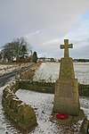 | |||
| Mill Of Tealing, Road Bridge Over Tealing Burn | 56°32′00″N 2°57′22″W | Category C(S) | 17454 | | |||
| Kirkton Of Tealing, Former Tealing Parish Church Hearse House | 56°31′47″N 2°58′17″W | Category B | 17451 | | |||
| South Balluderon Farm, Steading Including Stackyard Walls, Implement Shed, Field Trough And Mill Dam With Walls | 56°31′51″N 3°01′02″W | Category A | 17458 | | |||
| Tealing House, Tealing Home Farm, Old Mill | 56°31′56″N 2°57′22″W | Category C(S) | 18990 | | |||
| Balkello, Smithy Cottage | 56°31′53″N 3°01′04″W | Category C(S) | 17448 | | |||
| Balkemback Farm, Farmhouse | 56°31′51″N 2°59′26″W | Category C(S) | 17449 | | |||
| Kirkton Of Tealing, Old Manse, Gig House And Stable | 56°31′48″N 2°58′14″W | Category C(S) | 17452 | | |||
| Tealing House, Tealing Home Farm, Road Bridge Over Tealing Burn | 56°31′52″N 2°57′24″W | Category C(S) | 18991 | | |||
| Kirkton Of Tealing, Former Tealing Parish Church, Including Churchyard | 56°31′47″N 2°58′17″W | Category A | 17450 | 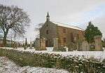 | |||
| South Balluderon Farm, Cottage And Former Bothy, Including Garden Walls | 56°31′50″N 3°00′58″W | Category B | 17456 | | |||
| Tealing House, Tealing Home Farm, Ice House On E Bank Of Tealing Burn | 56°31′54″N 2°57′23″W | Category B | 18989 | | |||
| Balgray, Back Law, Road Bridge Over The Burn Near Junction Of School And Huntingfaulds Roads | 56°32′13″N 2°57′49″W | Category C(S) | 17443 | | |||
| Balgray, Back Law, Road Bridge Over Tealing Burn | 56°32′08″N 2°58′00″W | Category C(S) | 17444 | |
Key
The scheme for classifying buildings in Scotland is:
- Category A: "buildings of national or international importance, either architectural or historic; or fine, little-altered examples of some particular period, style or building type."[1]
- Category B: "buildings of regional or more than local importance; or major examples of some particular period, style or building type, which may have been altered."[1]
- Category C: "buildings of local importance; lesser examples of any period, style, or building type, as originally constructed or moderately altered; and simple traditional buildings which group well with other listed buildings."[1]
In March 2016 there were 47,288 listed buildings in Scotland. Of these, 8% were Category A, and 50% were Category B, with the remaining 42% being Category C.[2]
gollark: Also, universities are horribly expensive in the UK, even though meanwhile on the other side of the Scottish border they manage to provide free tuition, which is, er, bad.
gollark: So could most things.
gollark: As someone in the school system, I don't like it.
gollark: Isn't that merit goods and not inelastic demand?
gollark: It'll finally be able to negotiate better trade deals with aliens!
See also
Notes
- Sometimes known as OSGB36, the grid reference (where provided) is based on the British national grid reference system used by the Ordnance Survey.
• "Guide to National Grid". Ordnance Survey. Retrieved 2007-12-12.
• "Get-a-map". Ordnance Survey. Retrieved 2007-12-17. - Historic Environment Scotland assign a unique alphanumeric identifier to each designated site in Scotland, for listed buildings this always begins with "LB", for example "LB12345".
References
- All entries, addresses and coordinates are based on data from Historic Scotland. This data falls under the Open Government Licence
- "What is Listing?". Historic Environment Scotland. Retrieved 29 May 2018.
- Scotland's Historic Environment Audit 2016 (PDF). Historic Environment Scotland and the Built Environment Forum Scotland. pp. 15–16. Retrieved 29 May 2018.
This article is issued from Wikipedia. The text is licensed under Creative Commons - Attribution - Sharealike. Additional terms may apply for the media files.