List of listed buildings in Strichen, Aberdeenshire
List
| Name | Location | Date Listed | Grid Ref. [note 1] | Geo-coordinates | Notes | LB Number [note 2] | Image |
|---|---|---|---|---|---|---|---|
| Bogensourie Cottage | 57°36′09″N 2°05′46″W | Category B | 16539 |  | |||
| 23, 25 Water Street | 57°35′13″N 2°05′36″W | Category C(S) | 16556 | | |||
| All Saints' Episcopal Church, Hall And Schoolhouse, North Street | 57°35′19″N 2°05′31″W | Category C(S) | 16562 | | |||
| 2 North Street | 57°35′10″N 2°05′17″W | Category C(S) | 16564 | | |||
| Northcote, North Street | 57°35′09″N 2°05′25″W | Category B | 16565 | | |||
| Original Parish Church Of Strichen, South Aisle | 57°34′58″N 2°05′24″W | Category B | 16569 | | |||
| Hunter's Lodge, Mormond Hill | 57°36′05″N 2°03′42″W | Category C(S) | 16541 | | |||
| 75, 77 High Street Strichen | 57°35′15″N 2°05′31″W | Category C(S) | 16552 | | |||
| Anderson And Woodman Institute, Water Street | 57°35′18″N 2°05′41″W | Category B | 16558 | | |||
| Former Parish Church Of Strichen | 57°34′57″N 2°05′25″W | Category C(S) | 16570 | | |||
| Old Bridge Over Ugie Water At Mill Of Strichen | 57°35′19″N 2°05′46″W | Category B | 16568 | | |||
| Old Parish Church Graveyard | 57°34′57″N 2°05′24″W | Category C(S) | 16571 | | |||
| Techmuiry House And Offices | 57°37′51″N 2°04′20″W | Category B | 16540 | | |||
| Howford, Old Farmhouse | 57°35′00″N 2°04′45″W | Category C(S) | 16543 | | |||
| Strichen House, Doocot | 57°34′48″N 2°06′25″W | Category B | 16548 | | |||
| Mormond Hotel, Water Street At W. Corner With Bridge Street | 57°35′09″N 2°05′33″W | Category C(S) | 16559 | | |||
| Adziel House | 57°34′08″N 2°05′25″W | Category C(S) | 16545 | | |||
| New Leeds Church And Manse (Now Mrs. Smith) | 57°34′48″N 2°00′32″W | Category B | 16546 | | |||
| Strichen House, Kennels Cottage | 57°34′42″N 2°06′55″W | Category B | 16549 | | |||
| Bridge Over North Ugie Water On B 9093 | 57°35′21″N 2°05′46″W | Category C(S) | 16567 | | |||
| Mill Of Strichen | 57°35′19″N 2°05′46″W | Category B | 16538 | | |||
| Burnshangie Farmhouse And Walled Garden | 57°35′20″N 2°05′02″W | Category B | 16542 | | |||
| Strichen House, Stableblock, (Barnyards Of Strichen) Strichen Mains | 57°34′34″N 2°06′25″W | Category B | 16547 | | |||
| Town House High Street And Bridge Street | 57°35′11″N 2°05′27″W | Category A | 16551 | 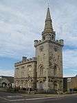 | |||
| 40, 42 North Street | 57°35′16″N 2°05′26″W | Category C(S) | 16563 | | |||
| Manse Of Strichen | 57°34′38″N 2°05′27″W | Category C(S) | 16572 | | |||
| Dairy (Gordon) High Street | 57°35′16″N 2°05′37″W | Category C(S) | 16555 | | |||
| 25 Bridge Street And S. Gibson's Shop | 57°35′10″N 2°05′28″W | Category C(S) | 16560 | | |||
| All Saint's Episcopal Church, West Street | 57°35′19″N 2°05′32″W | Category C(S) | 16561 | | |||
| Bridge Over North Ugie Water (A 981) At S.W. End Of Bridge Street | 57°35′07″N 2°05′33″W | Category C(S) | 16566 | | |||
| "Roman" Bridge, Howford, Over North Ugie Water | 57°34′54″N 2°04′47″W | Category C(S) | 16544 | | |||
| Mart House Market Street | 57°35′09″N 2°05′25″W | Category B | 16550 | | |||
| Holmwood, High Street | 57°35′20″N 2°05′39″W | Category B | 16554 | | |||
| Library House, Water Street | 57°35′17″N 2°05′40″W | Category B | 16557 | |
Key
The scheme for classifying buildings in Scotland is:
- Category A: "buildings of national or international importance, either architectural or historic; or fine, little-altered examples of some particular period, style or building type."[1]
- Category B: "buildings of regional or more than local importance; or major examples of some particular period, style or building type, which may have been altered."[1]
- Category C: "buildings of local importance; lesser examples of any period, style, or building type, as originally constructed or moderately altered; and simple traditional buildings which group well with other listed buildings."[1]
In March 2016 there were 47,288 listed buildings in Scotland. Of these, 8% were Category A, and 50% were Category B, with the remaining 42% being Category C.[2]
gollark: Write pointless code to reduce variable count!
gollark: One letter variables? Use zero letter variables.
gollark: It's great if you use Rust, otherwise horrible.
gollark: I dislike it but not because of that.
gollark: Some of it's probably Cthulu though. I mean, zygohistomorphic premorphisms.
Notes
- Sometimes known as OSGB36, the grid reference (where provided) is based on the British national grid reference system used by the Ordnance Survey.
• "Guide to National Grid". Ordnance Survey. Retrieved 2007-12-12.
• "Get-a-map". Ordnance Survey. Retrieved 2007-12-17. - Historic Environment Scotland assign a unique alphanumeric identifier to each designated site in Scotland, for listed buildings this always begins with "LB", for example "LB12345".
References
- All entries, addresses and coordinates are based on data from Historic Scotland. This data falls under the Open Government Licence
- "What is Listing?". Historic Environment Scotland. Retrieved 29 May 2018.
- Scotland's Historic Environment Audit 2016 (PDF). Historic Environment Scotland and the Built Environment Forum Scotland. pp. 15–16. Retrieved 29 May 2018.
This article is issued from Wikipedia. The text is licensed under Creative Commons - Attribution - Sharealike. Additional terms may apply for the media files.