List of listed buildings in Stonehaven, Aberdeenshire
List
| Name | Location | Date Listed | Grid Ref. [note 1] | Geo-coordinates | Notes | LB Number [note 2] | Image |
|---|---|---|---|---|---|---|---|
| 20 Bath Street, The Lilies Including Boundary Walls And Gates | 56°58′06″N 2°12′59″W | Category B | 41575 |  | |||
| Dunnottar Avenue, St Bridget's Hall For Dunnottar Church Including Boundary Walls, Gatepiers And Gates | 56°57′43″N 2°12′32″W | Category C(S) | 41584 | | |||
| 29 - 37 (Odd Nos) Cameron Street | 56°57′46″N 2°12′36″W | Category C(S) | 41587 | | |||
| 45 Cameron Street | 56°57′46″N 2°12′45″W | Category C(S) | 41589 | | |||
| 34 -38 (Even Nos) Cameron Street | 56°57′47″N 2°12′44″W | Category C(S) | 41596 | | |||
| 7 And 8 (Burnside) Carron Terrace Including Boundary Walls And Gatepiers | 56°57′45″N 2°12′46″W | Category B | 41607 | | |||
| 1 Castle Street | 56°57′35″N 2°12′16″W | Category B | 41609 | | |||
| High Street, The Cross, Market Cross | 56°57′39″N 2°12′16″W | Category B | 41616 | | |||
| 7, 9 And 11 Evan Street | 56°57′50″N 2°12′35″W | Category C(S) | 41620 | | |||
| 24 And 26 High Street | 56°57′41″N 2°12′24″W | Category C(S) | 41628 | | |||
| 28, 30 And 32 High Street, Christian's House | 56°57′41″N 2°12′22″W | Category B | 41629 | | |||
| 44, 46 And 48 High Street | 56°57′40″N 2°12′20″W | Category C(S) | 41631 | | |||
| 58 And 60 High Street | 56°57′40″N 2°12′18″W | Category C(S) | 41632 | | |||
| Market Square, Market Buildings | 56°57′51″N 2°12′30″W | Category B | 41640 | 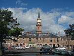 | |||
| Market Square Fountain | 56°57′51″N 2°12′30″W | Category B | 41641 | | |||
| 1, 2 And 3 Market Square | 56°57′49″N 2°12′30″W | Category B | 41642 | | |||
| 8, 9 And 10 Market Square | 56°57′49″N 2°12′32″W | Category C(S) | 41645 | | |||
| 26 And 27 Market Square, Former Bank Of Scotland, Including Boundary Walls, Railings And Gates | 56°57′52″N 2°12′33″W | Category C(S) | 41651 | | |||
| 30 Market Square | 56°57′52″N 2°12′32″W | Category C(S) | 41652 | | |||
| 47 Slug Road And 27 Bath Street, Kirk Cottage Including Boundary Walls | 56°58′05″N 2°13′05″W | Category C(S) | 41671 | | |||
| 1 Albert Lane Including Boundary Wall | 56°57′37″N 2°12′17″W | Category C(S) | 41530 | | |||
| 38 And 40 Allardice Street | 56°57′51″N 2°12′28″W | Category C(S) | 41535 | | |||
| 17 Ann Street | 56°57′50″N 2°12′37″W | Category C(S) | 41537 | | |||
| Bath Street, Stonehaven Community Education Centre Including Ancillary Building And Boundary Walls | 56°58′02″N 2°12′41″W | Category C(S) | 41544 | | |||
| 5 Arbuthnott Street | 56°57′45″N 2°12′32″W | Category C(S) | 41549 | | |||
| Baird Street,The Hermitage Including Summerhouse, Boundary Walls And Gatepiers | 56°58′06″N 2°12′43″W | Category B | 41555 | | |||
| 25 Market Square And 30A Barclay Street | 56°57′52″N 2°12′34″W | Category C(S) | 41569 | | |||
| 4 Bath Street, Ashvale Including Walled Garden, Railings, Gate And Gatepiers | 56°58′04″N 2°12′43″W | Category C(S) | 41572 | | |||
| 2 And 4 Albert Lane, 53, 55, 57 And 59 High Street, 11A, 15, 17 And 19 King Street, 4, 5 And 6 The Cross | 56°57′39″N 2°12′17″W | Category C(S) | 50237 | | |||
| 1 - 4 (Inclusive Nos) Ardley Terrace Including Ancillary Building And Boundary Wall | 56°57′46″N 2°12′51″W | Category C(S) | 50243 | | |||
| Arduthie Road, Viewmount, Council Offices Including Nuclear Bunker, Ancillary Building, Boundary Walls, Gatepiers And Railings | 56°57′51″N 2°12′57″W | Category C(S) | 50245 | | |||
| 2 Arduthie Road, Ewen Burn Including Boundary Walls, Railings And Gate | 56°57′50″N 2°12′51″W | Category C(S) | 50246 | | |||
| Bogwell Lane, Plague Gravestones | 56°57′39″N 2°12′30″W | Category B | 50249 | | |||
| 1 And 3 Bridgefield Including Boundary Walls | 56°57′44″N 2°12′31″W | Category C(S) | 50250 | | |||
| 2 Queen's Road, Claremont Including Boundary Walls, Gatepiers And Gates | 56°57′50″N 2°13′04″W | Category C(S) | 50264 | | |||
| 8 And 10 Slug Road Including Terraced Garden And Boundary Walls | 56°57′53″N 2°12′52″W | Category C(S) | 50269 | | |||
| Stonehaven Railway Station Including Signal Box | 56°58′00″N 2°13′31″W | Category B | 41672 | 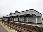 | |||
| Bath Street, Fetteresso (Church Of Scotland) | 56°58′07″N 2°13′01″W | Category A | 41576 | | |||
| 47 And 49 Cameron Street | 56°57′46″N 2°12′45″W | Category C(S) | 41590 | | |||
| 14 Carron Terrace Including Boundary Walls | 56°57′44″N 2°12′51″W | Category C(S) | 41608 | | |||
| Cowie Mill | 56°58′12″N 2°12′36″W | Category C(S) | 41614 | | |||
| 4 And 5 Market Square | 56°57′49″N 2°12′31″W | Category C(S) | 41643 | | |||
| Allardice Street, Queen's Hotel | 56°57′47″N 2°12′30″W | Category C(S) | 41532 | | |||
| 26 Ann Street, Johnston Lodge | 56°57′52″N 2°12′39″W | Category C(S) | 41541 | | |||
| 1 Arbuthnott Street Including Boundary Walls | 56°57′45″N 2°12′31″W | Category C(S) | 41547 | | |||
| Stonehaven Open Air Swimming Pool | 56°58′11″N 2°12′17″W | Category B | 50183 | | |||
| 60 Arduthie Road, Isla Bank Including Boundary Walls And Gatepiers | 56°57′57″N 2°13′07″W | Category C(S) | 50248 | | |||
| 1, 2 And 3 Bridgefield Terrace Including Boundary Walls | 56°57′43″N 2°12′32″W | Category C(S) | 50252 | | |||
| 26 To 32 (Even Nos) Evan Street | 56°57′49″N 2°12′38″W | Category C(S) | 50257 | | |||
| Glenury Viaduct, U/B Ecn5/340 | 56°58′26″N 2°12′58″W | Category B | 50258 | | |||
| Robert Street, Clashfarquhar Including Terraced Garden And Boundary Walls | 56°57′58″N 2°12′41″W | Category C(S) | 50265 | | |||
| Walker's Bridge, Woodcot Court, (Former Woodcot Hospital), Including Garden Walls And Lodges | 56°57′41″N 2°13′18″W | Category B | 41673 | | |||
| Bridgefield,1 - 5 (Inclusive Nos) Rickarton Cottages Including Boundary Walls, Gatepiers And Railings | 56°57′43″N 2°12′30″W | Category C(S) | 41585 | | |||
| 32 Cameron Street Including Ancillary Building And Boundary Walls | 56°57′47″N 2°12′44″W | Category C(S) | 41595 | | |||
| 42 And 44 Cameron Street | 56°57′47″N 2°12′46″W | Category C(S) | 41598 | | |||
| 46 Cameron Street | 56°57′47″N 2°12′47″W | Category C(S) | 41599 | | |||
| 50 Cameron Street | 56°57′47″N 2°12′50″W | Category C(S) | 41602 | | |||
| 23, 25 And 27 Evan Street | 56°57′50″N 2°12′37″W | Category C(S) | 41621 | | |||
| 33 Evan Street, Kinnear House, And 1 Robert Street Including Boundary Walls, Gatepiers And Railings | 56°57′50″N 2°12′41″W | Category B | 41622 | | |||
| Harbour Of Stonehaven | 56°57′37″N 2°12′06″W | Category B | 41625 | | |||
| 51A, B And C High Street | 56°57′39″N 2°12′19″W | Category B | 41626 | | |||
| 36 - 42 (Even Nos) High Street | 56°57′41″N 2°12′21″W | Category C(S) | 41630 | | |||
| 12, 14 And 16 Market Square | 56°57′50″N 2°12′34″W | Category B | 41647 | | |||
| 34 And 35 Market Square | 56°57′52″N 2°12′31″W | Category C(S) | 41654 | | |||
| Old Pier, Old Tolbooth Sundial | 56°57′38″N 2°12′07″W | Category B | 41656 | | |||
| Shorehead, Aberdeen And Stonehaven Yacht Club | 56°57′33″N 2°12′15″W | Category C(S) | 41667 | | |||
| 19, 21 And 23 Arbuthnott Place, Carron Springs, Bowmont House And Burnside Including Boundary Walls | 56°57′44″N 2°12′27″W | Category C(S) | 41545 | | |||
| 21 Bath Street, Ardgour Including Boundary Walls | 56°58′04″N 2°13′01″W | Category C(S) | 41571 | | |||
| 31 And 33 Allardice Street | 56°57′52″N 2°12′30″W | Category C(S) | 50238 | | |||
| 23 And 25 Ann Street | 56°57′51″N 2°12′37″W | Category C(S) | 50241 | | |||
| 46 Arduthie Road And 2 Princess Road Including Boundary Walls And Gatepiers | 56°57′57″N 2°13′01″W | Category C(S) | 50247 | | |||
| 10 And 12 Evan Street | 56°57′49″N 2°12′36″W | Category C(S) | 50256 | | |||
| High Street, Dunnottar Primary School Including Boundary Walls, Gatepiers, Gates, Railings And Janitor's Lodge | 56°57′41″N 2°12′28″W | Category C(S) | 50260 | | |||
| 23 Slug Road, Ashley Cottage, Including Boundary Walls And Gates | 56°57′53″N 2°12′48″W | Category C(S) | 50267 | | |||
| Stonehaven Recreation Grounds, Bowling Club Pavilion | 56°58′05″N 2°12′29″W | Category C(S) | 50271 | | |||
| Belmont Brae, Belmont House Including Boundary Walls, Gatepiers And Garden Railings | 56°58′04″N 2°12′37″W | Category C(S) | 41578 | | |||
| 51 Cameron Street | 56°57′46″N 2°12′46″W | Category C(S) | 41591 | | |||
| 7, 9 And 11 Castle Street | 56°57′34″N 2°12′18″W | Category C(S) | 41612 | | |||
| High Street, The Cross, The Town House | 56°57′39″N 2°12′16″W | Category B | 41615 | | |||
| Dunnottar Avenue, Sheriff Court House With Police Station Including Boundary Walls | 56°57′41″N 2°12′31″W | Category B | 41617 | | |||
| Evan Street, Langdon Including Ancillary Building, Boundary Walls And Gatepiers | 56°57′48″N 2°13′05″W | Category C(S) | 41624 | | |||
| 31 And 32 Market Square | 56°57′52″N 2°12′31″W | Category C(S) | 41653 | | |||
| 5 Shorehead, The Ship Inn | 56°57′38″N 2°12′14″W | Category C(S) | 41660 | | |||
| Shorehead, Marine Hotel | 56°57′37″N 2°12′15″W | Category C(S) | 41662 | | |||
| 18 Shorehead | 56°57′33″N 2°12′15″W | Category C(S) | 41666 | | |||
| Allardice Street, Town Hall | 56°57′50″N 2°12′28″W | Category B | 41534 | | |||
| 43 And 45 Barclay Street With 8A, 8B And 10 Mary Street | 56°57′54″N 2°12′33″W | Category C(S) | 41561 | | |||
| 45 And 47 Allardice Street | 56°57′53″N 2°12′31″W | Category C(S) | 50239 | | |||
| 20 Ann Street | 56°57′50″N 2°12′39″W | Category B | 50242 | | |||
| Arduthie Road, Arduthie Primary School Including War Memorial, Boundary Walls And Railings | 56°57′55″N 2°13′00″W | Category C(S) | 50244 | | |||
| 19 Bridgefield Including Milestone And Bridge Pier | 56°57′46″N 2°12′30″W | Category C(S) | 50251 | | |||
| 25 Slug Road, Rowandale Including Boundary Walls And Gates | 56°57′54″N 2°12′49″W | Category C(S) | 50268 | | |||
| 82 Cameron Street, Rosebank Cottage Including Ancillary Buildings, Boundary Walls And Railings | 56°57′47″N 2°13′02″W | Category B | 41604 | | |||
| 82 High Street | 56°57′39″N 2°12′15″W | Category C(S) | 41635 | | |||
| 3, 4 And 5 Old Pier | 56°57′39″N 2°12′09″W | Category B | 41658 | | |||
| 23 And 24 Shorehead | 56°57′32″N 2°12′14″W | Category C(S) | 41670 | | |||
| 11 And 13 Arbuthnott Street | 56°57′45″N 2°12′34″W | Category C(S) | 41551 | | |||
| Arbuthnott Street, St James The Great Episcopal Church Including Boundary Walls, Gatepiers And Gates | 56°57′45″N 2°12′36″W | Category A | 41552 | .jpg) | |||
| 15, 17 And 19 Barclay Street | 56°57′49″N 2°12′33″W | Category C(S) | 41557 | | |||
| Mineralwell Park, St Kieran's Well | 56°58′22″N 2°13′05″W | Category C(S) | 50263 | | |||
| 15 And 15A Robert Street, Ellerslie House | 56°57′56″N 2°12′41″W | Category C(S) | 50266 | | |||
| Stonehaven Railway Station, Goods Sheds | 56°58′00″N 2°13′29″W | Category C(S) | 50270 | | |||
| 60 And 62 Barclay Street | 56°57′55″N 2°12′35″W | Category C(S) | 50272 | | |||
| 24 Market Square | 56°57′51″N 2°12′35″W | Category C(S) | 51028 | | |||
| 11 Bridgefield | 56°57′45″N 2°12′31″W | Category C(S) | 41581 | | |||
| 26 And 28 Cameron Street, Cameron House Including Boundary Walls | 56°57′47″N 2°12′42″W | Category B | 41594 | | |||
| 74 Cameron Street, South Church Manse, Including Boundary Walls And Gatepiers | 56°57′48″N 2°12′58″W | Category B | 41603 | | |||
| 3 Castle Street | 56°57′35″N 2°12′16″W | Category C(S) | 41610 | | |||
| 1, 3 And 5 Evan Street | 56°57′50″N 2°12′35″W | Category C(S) | 41619 | | |||
| Keith Place, Rivendell, Former Textile Yard Including Sea Wall | 56°57′40″N 2°12′13″W | Category A | 41638 | | |||
| 1, 1A And 2 Old Pier Including Boundary Walls | 56°57′39″N 2°12′10″W | Category C(S) | 41657 | | |||
| Shorehead, Duthie's Well | 56°57′38″N 2°12′12″W | Category B | 41659 | | |||
| 14 Shorehead | 56°57′35″N 2°12′15″W | Category C(S) | 41665 | | |||
| 3 Arbuthnott Street | 56°57′45″N 2°12′32″W | Category C(S) | 41548 | | |||
| 4 Bridgefield Terrace, Coach House Including Boundary Walls, Railings And Gate | 56°57′43″N 2°12′34″W | Category C(S) | 50253 | | |||
| High Street, Sea Cadet Hall, Former Episcopal School Including Boundary Walls | 56°57′39″N 2°12′23″W | Category C(S) | 50259 | | |||
| 9 High Street Including Ancillary Building And Boundary Walls | 56°57′40″N 2°12′25″W | Category C(S) | 50261 | | |||
| 4 John Street | 56°57′38″N 2°12′15″W | Category C(S) | 50262 | | |||
| 85 Cameron Street, Carronbank House Including Terraced Garden, Boundary Walls, Gatepiers And Gates | 56°57′45″N 2°13′10″W | Category A | 41593 | | |||
| 40 Cameron Street | 56°57′47″N 2°12′45″W | Category C(S) | 41597 | | |||
| 1 Carron Terrace, Woodburn Including Boundary Walls And Ancillary Building | 56°57′46″N 2°12′43″W | Category C(S) | 41606 | | |||
| 2, 4 And 6 Evan Street | 56°57′49″N 2°12′35″W | Category C(S) | 41623 | | |||
| 8 High Street | 56°57′42″N 2°12′27″W | Category C(S) | 41627 | | |||
| 94 And 96 High Street | 56°57′39″N 2°12′12″W | Category C(S) | 41637 | | |||
| 11 Market Square And 23 Barclay Street | 56°57′49″N 2°12′33″W | Category C(S) | 41646 | | |||
| Old Pier, Old Tolbooth Of Stonehaven Including Boundary Walls And Gates | 56°57′39″N 2°12′08″W | Category A | 41655 | | |||
| Allardice Street, Former Crown Hotel | 56°57′50″N 2°12′28″W | Category C(S) | 41533 | | |||
| Allardice Street, Royal Hotel | 56°57′51″N 2°12′28″W | Category C(S) | 41536 | | |||
| 21 And 21A Ann Street | 56°57′50″N 2°12′37″W | Category C(S) | 41539 | | |||
| Ann Street, Clydesdale Bank And 29 Evan Street Including Boundary Walls And Gatepier | 56°57′50″N 2°12′39″W | Category B | 41540 | | |||
| Arbuthnott Place, Roman Catholic Church Of The Immaculate Conception Including Boundary Walls, Gates, Railings And Soup Kitchen | 56°57′43″N 2°12′28″W | Category B | 41546 | | |||
| Barclay Street, Invercowie House And Plas Newyd, Including Garden Wall, Gate And Ancillary Building | 56°58′01″N 2°12′36″W | Category B | 41570 | | |||
| 19 Cameron Street | 56°57′46″N 2°12′34″W | Category C(S) | 50254 | | |||
| 2 Carron Terrace, Gowan Bank Including Boundary Walls | 56°57′46″N 2°12′43″W | Category C(S) | 50255 | | |||
| 6 Bath Street, Bath Lodge Including Boundary Walls, Gatepiers, Gate And Standard Lamp | 56°58′05″N 2°12′48″W | Category B | 41573 | | |||
| 18 Bath Street, Tudor Lodge Including Boundary Walls | 56°58′06″N 2°12′57″W | Category B | 41574 | | |||
| Westfield Road, Heugh Hotel Including Ancillary Building Boundary Walls And Gatepiers | 56°58′06″N 2°13′10″W | Category B | 41577 | | |||
| 41 And 43 Cameron Street Incorporating 3 Carron Terrace, Medwyn Cottage Incl Boundary Walls | 56°57′46″N 2°12′44″W | Category C(S) | 41588 | | |||
| Cameron Street, South Church, Church Of Scotland Parish Church, Including Church Hall | 56°57′46″N 2°12′47″W | Category C(S) | 41592 | | |||
| 20 Cameron Street, Carron Restaurant, Including Terraced Garden, Boundary Walls, Gatepiers And Gates | 56°57′48″N 2°12′39″W | Category B | 41605 | | |||
| Cowie Bridge Over Cowie Water | 56°58′04″N 2°12′34″W | Category B | 41613 | | |||
| 5 - 16 (Inclusive Nos) Bridgefield Terrace, The Mill Inn | 56°57′43″N 2°12′35″W | Category B | 41618 | | |||
| 6 And 7 Market Square | 56°57′49″N 2°12′31″W | Category C(S) | 41644 | | |||
| Shorehead, The Granary | 56°57′36″N 2°12′15″W | Category C(S) | 41663 | | |||
| 19 Shorehead | 56°57′33″N 2°12′15″W | Category B | 41668 | | |||
| 19 Ann Street | 56°57′50″N 2°12′37″W | Category C(S) | 41538 | | |||
| 56 Ann Street, Harley House Including Boundary Walls, Gatepiers, Gates And Railings | 56°57′57″N 2°12′39″W | Category B | 41543 | | |||
| 7 And 9 Arbuthnott Street | 56°57′45″N 2°12′33″W | Category C(S) | 41550 | | |||
| Arbuthnott Street, White Bridge | 56°57′46″N 2°12′38″W | Category C(S) | 41553 | 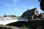 | |||
| Arduthie Road, Edenholme Including Boundary Walls And Gatepiers | 56°57′58″N 2°13′12″W | Category C(S) | 41554 | | |||
| 8 Barclay Street | 56°57′48″N 2°12′35″W | Category C(S) | 41563 | | |||
| 10 Barclay Street | 56°57′48″N 2°12′35″W | Category B | 41564 | | |||
| 22 Bath Street, Maxieburn Including Boundary Walls And Gates | 56°58′06″N 2°13′05″W | Category C(S) | 49508 | | |||
| 8 Allardice Street | 56°57′48″N 2°12′29″W | Category C(S) | 50240 | |
Key
The scheme for classifying buildings in Scotland is:
- Category A: "buildings of national or international importance, either architectural or historic; or fine, little-altered examples of some particular period, style or building type."[1]
- Category B: "buildings of regional or more than local importance; or major examples of some particular period, style or building type, which may have been altered."[1]
- Category C: "buildings of local importance; lesser examples of any period, style, or building type, as originally constructed or moderately altered; and simple traditional buildings which group well with other listed buildings."[1]
In March 2016 there were 47,288 listed buildings in Scotland. Of these, 8% were Category A, and 50% were Category B, with the remaining 42% being Category C.[2]
gollark: This will also not work because *the bot is down*.
gollark: You can see it's "offline". This is because bots have their own servers which sometimes fail.
gollark: If you had *my* bot, we could *constantly* play osmarks internet radio™.
gollark: Presumably, the bot is unfathomably down right now.
gollark: <@!683735247489466397> play https://radio-ic.osmarks.net/128k.ogg
Notes
- Sometimes known as OSGB36, the grid reference (where provided) is based on the British national grid reference system used by the Ordnance Survey.
• "Guide to National Grid". Ordnance Survey. Retrieved 12 December 2007.
• "Get-a-map". Ordnance Survey. Retrieved 17 December 2007. - Historic Environment Scotland assign a unique alphanumeric identifier to each designated site in Scotland, for listed buildings this always begins with "LB", for example "LB12345".
References
- All entries, addresses and coordinates are based on data from Historic Scotland. This data falls under the Open Government Licence
- "What is Listing?". Historic Environment Scotland. Retrieved 29 May 2018.
- Scotland's Historic Environment Audit 2016 (PDF). Historic Environment Scotland and the Built Environment Forum Scotland. pp. 15–16. Retrieved 29 May 2018.
This article is issued from Wikipedia. The text is licensed under Creative Commons - Attribution - Sharealike. Additional terms may apply for the media files.