List of listed buildings in Stewarton, East Ayrshire
List
| Name | Location | Date Listed | Grid Ref. [note 1] | Geo-coordinates | Notes | LB Number [note 2] | Image |
|---|---|---|---|---|---|---|---|
| Lainshaw House | 55°40′29″N 4°31′47″W | Category B | 41076 | 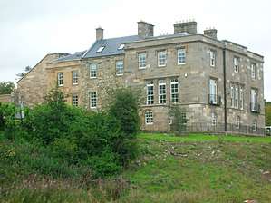 | |||
| 41 Graham Terrace, Ashbank Including Gatepiers | 55°41′03″N 4°31′02″W | Category C(S) | 41082 |  | |||
| Robertland Bridge Over Annick Water | 55°41′35″N 4°29′04″W | Category C(S) | 19884 | | |||
| 21 Draffen Mount, Draffen House | 55°40′37″N 4°30′22″W | Category C(S) | 45920 | | |||
| 22 And 24 Lainshaw Street, Including The Royal Bank Of Scotland | 55°40′47″N 4°30′57″W | Category C(S) | 51375 | | |||
| 11-15 (Odd Nos) Main Street | 55°40′49″N 4°30′54″W | Category C(S) | 51377 | | |||
| Annick Water Viaduct | 55°40′38″N 4°31′10″W | Category B | 41074 | 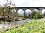 | |||
| Kilwinning Road, Dovecot At Deersland Farm | 55°40′17″N 4°34′18″W | Category C(S) | 18491 | | |||
| Kilwinning Road, Kennox Cottage | 55°40′12″N 4°34′12″W | Category C(S) | 18493 | | |||
| Old Glasgow Road, Fulshaw Farm | 55°41′44″N 4°29′20″W | Category C(S) | 18495 | | |||
| 2 Robertland, The Gatehouse, Including Gate Piers | 55°41′39″N 4°29′28″W | Category C(S) | 18499 | | |||
| Old Kilmarnock Road, High Peacockbank House | 55°40′13″N 4°30′43″W | Category C(S) | 18500 | | |||
| Auchentiber House, Including Outbuildings And Boundary Walls And Gatepiers | 55°42′35″N 4°29′01″W | Category C(S) | 51553 | | |||
| 15 Vennel Street, Woodlands, Including Gate Piers And Boundary Walls | 55°40′46″N 4°30′48″W | Category C(S) | 41069 | | |||
| 14 And 16 Kirkford | 55°40′33″N 4°30′41″W | Category C(S) | 41072 | | |||
| 2 And 7 David Dale Avenue, (Former East Gate To Lainshaw House) | 55°40′35″N 4°31′38″W | Category C(S) | 41077 | | |||
| Lainshaw Stables | 55°40′33″N 4°31′49″W | Category B | 41078 | | |||
| Girgenti Cottage | 55°39′25″N 4°36′00″W | Category C(S) | 18488 | | |||
| Old Glasgow Road, High Williamshaw, Including Outbuilding | 55°42′12″N 4°29′02″W | Category A | 18496 | 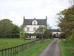 | |||
| Cutstraw Cottage | 55°40′45″N 4°29′41″W | Category C(S) | 18501 | | |||
| 8 Vennel Street | 55°40′48″N 4°30′54″W | Category C(S) | 49115 | | |||
| Dalry Road, Cemetery House And Offices, Including Gates And Gatepiers | 55°40′55″N 4°31′31″W | Category C(S) | 51370 | | |||
| 3-7 (Odd Nos) Lainshaw Street | 55°40′49″N 4°30′56″W | Category C(S) | 51371 | | |||
| 1 Loudoun Street | 55°40′35″N 4°30′39″W | Category C(S) | 51376 | | |||
| High Street, John Knox Parish Church, (Church Of Scotland) | 55°40′51″N 4°30′50″W | Category B | 41065 | 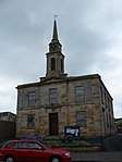 | |||
| Girgenti Farm, Including Tower And Outbuildings | 55°39′29″N 4°36′02″W | Category C(S) | 18486 | 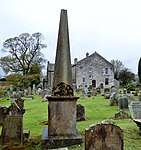 | |||
| Robertland, Including Outbuildings, Cottage And Walled Garden | 55°41′30″N 4°28′54″W | Category B | 18498 | | |||
| Merryhill Farm And Ancillary Buildings | 55°42′22″N 4°29′39″W | Category C(S) | 18505 | | |||
| 8 Avenue Square, Former Burgh Offices | 55°40′53″N 4°30′52″W | Category C(S) | 41067 | | |||
| High Street And Avenue Square, Including 2B High Street, Bank Of Scotland | 55°40′51″N 4°30′52″W | Category C(S) | 41068 | | |||
| 30 Vennel Street And 32 Vennel Street, Braehead House | 55°40′45″N 4°30′51″W | Category B | 41070 | | |||
| Auchenharvie Castle | 55°39′53″N 4°36′16″W | Category B | 18485 | | |||
| 2-6 (Even Nos) Lainshaw Street & 2-6 (Even Nos) Vennel Street | 55°40′48″N 4°30′55″W | Category C(S) | 49114 | | |||
| 16-20 (Even Nos) Lainshaw Street, Including Outbuildings | 55°40′48″N 4°30′56″W | Category C(S) | 51552 | | |||
| Avenue Square, Institute Hall | 55°40′51″N 4°30′53″W | Category C(S) | 41066 | | |||
| 16, 18 And 20 Standalane, Standalane House | 55°38′45″N 4°31′45″W | Category C(S) | 41075 | | |||
| Kilwinning Road, Lainshaw Mains Farm | 55°40′41″N 4°31′55″W | Category B | 41079 | 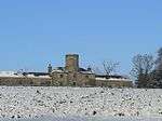 | |||
| Corsehill Castle | 55°41′12″N 4°31′09″W | Category B | 41080 | | |||
| 9-13 (Odd Nos) Lainshaw Street | 55°40′49″N 4°30′57″W | Category C(S) | 51372 | | |||
| 14 Lainshaw Street | 55°40′48″N 4°30′56″W | Category C(S) | 51374 | | |||
| 12 Kirkford | 55°40′36″N 4°30′41″W | Category C(S) | 41071 | | |||
| 13 Vennel Street, Kersland | 55°40′47″N 4°30′50″W | Category B | 41081 | | |||
| Chapeltoun House | 55°39′54″N 4°33′11″W | Category C(S) | 51379 |  | |||
| 13 Loudoun Street, Cragston House | 55°40′32″N 4°30′26″W | Category C(S) | 51389 | | |||
| St Columba's Parish Church And Kirkyard, Including Boundary Walls, (Church Of Scotland) | 55°40′44″N 4°30′58″W | Category B | 41063 | 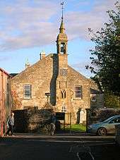 | |||
| Little Cutstraw House | 55°40′27″N 4°30′02″W | Category C(S) | 19885 | | |||
| Fairliecrevoch Farm, Including The Farmhouse, The Stone Barn, The Auld Dairy, The Old Byre And The Stable | 55°38′52″N 4°35′34″W | Category C(S) | 18489 | | |||
| Kennox House, Including Gatepiers And Gates And Boundary Walls | 55°40′16″N 4°34′12″W | Category A | 18490 | | |||
| 15-19 (Odd Nos) Lainshaw Street | 55°40′48″N 4°30′57″W | Category C(S) | 51373 | |
Key
The scheme for classifying buildings in Scotland is:
- Category A: "buildings of national or international importance, either architectural or historic; or fine, little-altered examples of some particular period, style or building type."[1]
- Category B: "buildings of regional or more than local importance; or major examples of some particular period, style or building type, which may have been altered."[1]
- Category C: "buildings of local importance; lesser examples of any period, style, or building type, as originally constructed or moderately altered; and simple traditional buildings which group well with other listed buildings."[1]
In March 2016 there were 47,288 listed buildings in Scotland. Of these, 8% were Category A, and 50% were Category B, with the remaining 42% being Category C.[2]
gollark: https://wiki.computercraft.cc/Network_security
gollark: It's all public and plaintext.
gollark: Just listen on rednet.CHANNEL_REPEAT.
gollark: What? They can easily.
gollark: There is literally nothing stopping people from- reading all messages and seeing what transactions happen- pretending to be an ATM or the bank server
Notes
- Sometimes known as OSGB36, the grid reference (where provided) is based on the British national grid reference system used by the Ordnance Survey.
• "Guide to National Grid". Ordnance Survey. Retrieved 12 December 2007.
• "Get-a-map". Ordnance Survey. Retrieved 17 December 2007. - Historic Environment Scotland assign a unique alphanumeric identifier to each designated site in Scotland, for listed buildings this always begins with "LB", for example "LB12345".
References
- All entries, addresses and coordinates are based on data from Historic Scotland. This data falls under the Open Government Licence
- "What is Listing?". Historic Environment Scotland. Retrieved 29 May 2018.
- Scotland's Historic Environment Audit 2016 (PDF). Historic Environment Scotland and the Built Environment Forum Scotland. pp. 15–16. Retrieved 29 May 2018.
This article is issued from Wikipedia. The text is licensed under Creative Commons - Attribution - Sharealike. Additional terms may apply for the media files.